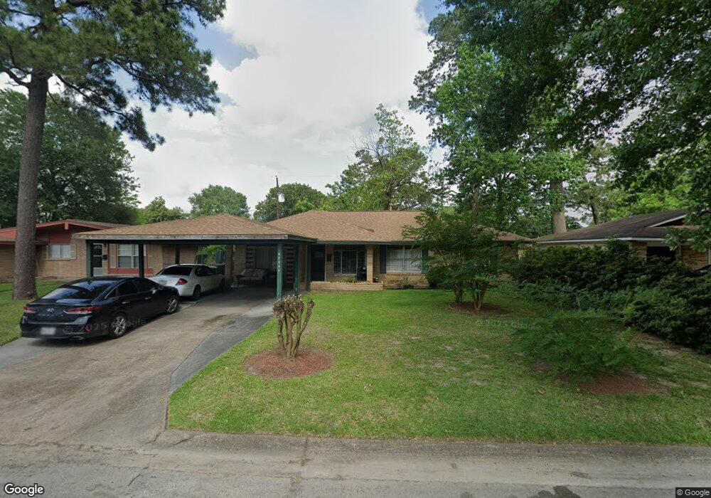
10330 Royal Oaks Dr Houston, TX 77016
East Little York NeighborhoodEstimated Value: $143,000 - $171,922
3
Beds
2
Baths
1,323
Sq Ft
$123/Sq Ft
Est. Value
About This Home
This home is located at 10330 Royal Oaks Dr, Houston, TX 77016 and is currently estimated at $162,481, approximately $122 per square foot. 10330 Royal Oaks Dr is a home located in Harris County with nearby schools including Shadydale Elementary School, Forest Brook Middle, and North Forest High School.
Ownership History
Date
Name
Owned For
Owner Type
Purchase Details
Closed on
Aug 20, 1997
Sold by
Davis George W and Davis Doris L
Bought by
Ford Selena
Current Estimated Value
Home Financials for this Owner
Home Financials are based on the most recent Mortgage that was taken out on this home.
Original Mortgage
$25,650
Interest Rate
7.47%
Purchase Details
Closed on
Nov 1, 1994
Sold by
Pipkin Charles P and Pipkin Ida M
Bought by
Investments Big 3 Llc
Create a Home Valuation Report for This Property
The Home Valuation Report is an in-depth analysis detailing your home's value as well as a comparison with similar homes in the area
Home Values in the Area
Average Home Value in this Area
Purchase History
| Date | Buyer | Sale Price | Title Company |
|---|---|---|---|
| Ford Selena | -- | Texas American Title Company | |
| Investments Big 3 Llc | -- | -- |
Source: Public Records
Mortgage History
| Date | Status | Borrower | Loan Amount |
|---|---|---|---|
| Closed | Ford Selena | $25,650 |
Source: Public Records
Tax History Compared to Growth
Tax History
| Year | Tax Paid | Tax Assessment Tax Assessment Total Assessment is a certain percentage of the fair market value that is determined by local assessors to be the total taxable value of land and additions on the property. | Land | Improvement |
|---|---|---|---|---|
| 2025 | $2,033 | $160,570 | $55,276 | $105,294 |
| 2024 | $2,033 | $156,064 | $39,018 | $117,046 |
| 2023 | $2,033 | $154,955 | $39,018 | $115,937 |
| 2022 | $2,020 | $147,106 | $39,018 | $108,088 |
| 2021 | $1,943 | $116,039 | $26,012 | $90,027 |
| 2020 | $1,836 | $100,359 | $17,558 | $82,801 |
| 2019 | $1,744 | $77,583 | $11,121 | $66,462 |
| 2018 | $114 | $62,652 | $11,121 | $51,531 |
| 2017 | $1,526 | $62,652 | $11,121 | $51,531 |
| 2016 | $1,387 | $59,977 | $11,121 | $48,856 |
| 2015 | $75 | $56,196 | $11,121 | $45,075 |
| 2014 | $75 | $48,147 | $11,121 | $37,026 |
Source: Public Records
Map
Nearby Homes
- 10430 Royal Oaks Dr
- 10317 Kelburn Dr
- 10221 Bretton Dr
- 10434 Envoy St
- 7210 Colton St
- 10201 Homestead Rd
- 10526 Hollyglen Dr
- 7226 Gore Dr
- 10122 Rockaway Dr
- 10128 Homestead Rd
- 10538 Royal Oaks Dr
- 10806 Bird of Paradise Ln
- 10808 Bird of Paradise Ln
- 10810 Bird of Paradise Ln
- 10535 Hollyglen Dr
- 10124 Homestead Rd
- 10120 Homestead Rd
- 6001 Bretshire Dr
- 7234 Boggess Rd
- 5905 Langley Rd
- 10326 Royal Oaks Dr
- 10331 Rockaway Dr
- 10435 Royal Oaks Dr
- 10335 Rockaway Dr
- 10327 Rockaway Dr
- 10322 Royal Oaks Dr
- 10402 Royal Oaks Dr
- 10403 Rockaway Dr
- 10323 Rockaway Dr
- 10331 Royal Oaks Dr
- 10335 Royal Oaks Dr
- 10327 Royal Oaks Dr
- 10318 Royal Oaks Dr
- 10406 Royal Oaks Dr
- 10403 Royal Oaks Dr
- 10323 Royal Oaks Dr
- 10319 Rockaway Dr
- 10407 Rockaway Dr
- 10407 Royal Oaks Dr
- 10410 Royal Oaks Dr