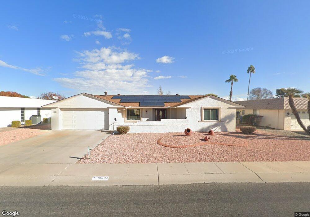
10332 W Brookside Dr Sun City, AZ 85351
Estimated Value: $287,018 - $510,000
--
Bed
2
Baths
1,597
Sq Ft
$234/Sq Ft
Est. Value
About This Home
This home is located at 10332 W Brookside Dr, Sun City, AZ 85351 and is currently estimated at $374,255, approximately $234 per square foot. 10332 W Brookside Dr is a home located in Maricopa County with nearby schools including Sonoran Science Academy-Peoria, Desert Mirage Elementary School, and Black Mountain Science Academy Montessori.
Ownership History
Date
Name
Owned For
Owner Type
Purchase Details
Closed on
May 3, 1995
Sold by
Erwin Roy A and Erwin Margaret C
Bought by
Erwin Roy A and Erwin Margaret C
Current Estimated Value
Purchase Details
Closed on
May 3, 1994
Sold by
Fly Stanley M and Fly Adelaide B
Bought by
Erwin Roy A and Erwin Margaret C
Home Financials for this Owner
Home Financials are based on the most recent Mortgage that was taken out on this home.
Original Mortgage
$45,000
Interest Rate
8.53%
Mortgage Type
New Conventional
Create a Home Valuation Report for This Property
The Home Valuation Report is an in-depth analysis detailing your home's value as well as a comparison with similar homes in the area
Home Values in the Area
Average Home Value in this Area
Purchase History
| Date | Buyer | Sale Price | Title Company |
|---|---|---|---|
| Erwin Roy A | -- | -- | |
| Erwin Roy A | $125,000 | First American Title |
Source: Public Records
Mortgage History
| Date | Status | Borrower | Loan Amount |
|---|---|---|---|
| Closed | Erwin Roy A | $45,000 |
Source: Public Records
Tax History Compared to Growth
Tax History
| Year | Tax Paid | Tax Assessment Tax Assessment Total Assessment is a certain percentage of the fair market value that is determined by local assessors to be the total taxable value of land and additions on the property. | Land | Improvement |
|---|---|---|---|---|
| 2025 | $1,564 | $19,361 | -- | -- |
| 2024 | $1,412 | $18,439 | -- | -- |
| 2023 | $1,412 | $27,200 | $5,440 | $21,760 |
| 2022 | $1,321 | $23,150 | $4,630 | $18,520 |
| 2021 | $1,364 | $21,900 | $4,380 | $17,520 |
| 2020 | $1,328 | $19,670 | $3,930 | $15,740 |
| 2019 | $1,311 | $19,370 | $3,870 | $15,500 |
| 2018 | $1,261 | $17,130 | $3,420 | $13,710 |
| 2017 | $1,215 | $15,520 | $3,100 | $12,420 |
| 2016 | $644 | $14,220 | $2,840 | $11,380 |
| 2015 | $1,088 | $13,810 | $2,760 | $11,050 |
Source: Public Records
Map
Nearby Homes
- 10313 W Desert Rock Dr
- 10313 W Burns Dr
- 16202 N 106th Ave
- 10329 W Gulf Hills Dr
- 10214 W Hutton Dr Unit 36
- 10134 W Desert Rock Dr
- 10511 W Edgewood Dr
- 16801 N 103rd Ave
- 10608 W Edgewood Dr
- 10401 W Loma Blanca Dr
- 16822 N 102nd Ave
- 16822 N Boswell Blvd
- 10650 W Brookside Dr
- 16802 N Boswell Blvd
- 10443 W Loma Blanca Dr
- 10202 W Edgewood Dr
- 16842 N 103rd Dr
- 10461 W Loma Blanca Dr
- 10544 W Pineaire Dr
- 10533 W Hutton Dr
- 10326 W Brookside Dr
- 10338 W Brookside Dr
- 10320 W Brookside Dr
- 10402 W Brookside Dr
- 10331 W Brookside Dr
- 10337 W Brookside Dr
- 10325 W Brookside Dr
- 10401 W Brookside Dr
- 10408 W Brookside Dr
- 10319 W Brookside Dr
- 10319 W Brookside Dr Unit 33
- 10407 W Brookside Dr
- 10402 W Sutters Gold Ln
- 10332 W Sutters Gold Ln
- 10313 W Brookside Dr
- 10408 W Sutters Gold Ln Unit 33
- 10326 W Sutters Gold Ln
- 10414 W Brookside Dr
- 10413 W Brookside Dr
- 10308 W Brookside Dr