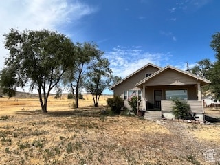
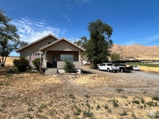
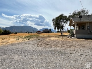
10336 S 6000 W Payson, UT 84651
Estimated payment $4,375/month
Highlights
- Horse Property
- Mountain View
- Wood Flooring
- Mature Trees
- Rambler Architecture
- Main Floor Primary Bedroom
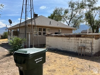
About This Home
Great livestock property available. Water is also included so it can be irrigated. There are 11.29 water shares and .45 acre feet of water included. It has been farmed in the past, but not in the last several years. The septic system is 4-5 years old, and the house has been well maintained. Square footage figures are provided as a courtesy estimate only and were obtained from county records. Buyer is advised to obtain an independent measurement.
Listing Agent
Hillary Miller
Equity Real Estate (Advisors) License #11167765 Listed on: 09/09/2025
Home Details
Home Type
- Single Family
Est. Annual Taxes
- $1,667
Year Built
- Built in 1929
Lot Details
- 5.25 Acre Lot
- East Facing Home
- Irrigation
- Mature Trees
- Property is zoned Single-Family, Agricultural
Home Design
- Rambler Architecture
- Pitched Roof
- Asphalt Roof
- Asphalt
Interior Spaces
- 2,088 Sq Ft Home
- 2-Story Property
- Ceiling Fan
- Drapes & Rods
- Blinds
- Mountain Views
- Electric Dryer Hookup
Kitchen
- Gas Oven
- Gas Range
Flooring
- Wood
- Carpet
- Laminate
- Tile
Bedrooms and Bathrooms
- 2 Bedrooms | 1 Primary Bedroom on Main
- 1 Full Bathroom
- Hydromassage or Jetted Bathtub
- Bathtub With Separate Shower Stall
Basement
- Basement Fills Entire Space Under The House
- Natural lighting in basement
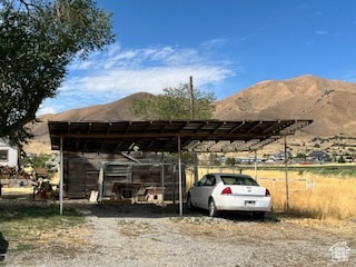
Parking
- 2 Parking Spaces
- 2 Carport Spaces
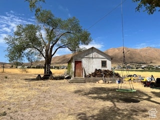
Outdoor Features
- Horse Property
- Covered Patio or Porch
- Outbuilding
Schools
- Taylor Elementary School
- Mt. Nebo Middle School
- Salem Hills High School
Utilities
- Evaporated cooling system
- Forced Air Heating System
- Natural Gas Connected
- Well
- Septic Tank
Additional Features
- Level Entry For Accessibility
- 11 Irrigated Acres
Community Details
- No Home Owners Association
- Kester Subdivision
Listing and Financial Details
- Exclusions: Dryer, Freezer, Microwave, Refrigerator, Washer, Window Coverings
- Assessor Parcel Number 44-143-0003
Map
Tax History
We collect this data history from publicly available records. To have your information removed, we recommend requesting removal directly through your county’s website.
| Year | Tax Paid | Tax Assessment Tax Assessment Total Assessment is a certain percentage of the fair market value that is determined by local assessors to be the total taxable value of land and additions on the property. | Land | Improvement |
|---|---|---|---|---|
| 2025 | $1,668 | $194,770 | -- | -- |
| 2024 | $1,668 | $166,690 | $0 | $0 |
| 2023 | $1,619 | $161,930 | $0 | $0 |
| 2022 | $1,344 | $589,200 | $465,100 | $124,100 |
| 2021 | $1,155 | $422,500 | $329,200 | $93,300 |
| 2020 | $840 | $374,700 | $281,400 | $93,300 |
| 2019 | $768 | $317,100 | $232,300 | $84,800 |
| 2018 | $729 | $286,000 | $212,300 | $73,700 |
| 2017 | $664 | $51,655 | $0 | $0 |
| 2016 | $595 | $44,840 | $0 | $0 |
| 2015 | $579 | $43,285 | $0 | $0 |
| 2014 | $580 | $43,370 | $0 | $0 |
Property History
We collect this data history from publicly available records. To have your information removed, we recommend requesting removal directly through your county’s website.
| Date | Event | Price | List to Sale | Price per Sq Ft |
|---|---|---|---|---|
| 05/12/2026 05/12/26 | Price Changed | $785,000 | -1.8% | $376 / Sq Ft |
| 03/09/2026 03/09/26 | For Sale | $799,000 | 0.0% | $383 / Sq Ft |
| 03/06/2026 03/06/26 | Off Market | -- | -- | -- |
| 09/09/2025 09/09/25 | For Sale | $799,000 | -- | $383 / Sq Ft |
Purchase History
We collect this data history from publicly available records. To have your information removed, we recommend requesting removal directly through your county’s website.
| Date | Type | Sale Price | Title Company |
|---|---|---|---|
| Warranty Deed | -- | First American Title Agency | |
| Warranty Deed | -- | Security Title & Abstract | |
| Quit Claim Deed | -- | Provo Land Title Company |
Mortgage History
We collect this data history from publicly available records. To have your information removed, we recommend requesting removal directly through your county’s website.
| Date | Status | Loan Amount | Loan Type |
|---|---|---|---|
| Open | $154,900 | Fannie Mae Freddie Mac | |
| Previous Owner | $165,200 | Fannie Mae Freddie Mac |
Source: UtahRealEstate.com
MLS Number: 2110324
APN: 44-143-0003
Disclaimer: Certain information contained herein is derived from information provided by parties other than Homes.com. All information provided is deemed reliable, but is not guaranteed to be accurate and should be independently verified.
![]() IDX information is provided exclusively for consumers’ personal, non-commercial use, that it may not be used for any purpose other than to identify prospective properties consumers may be interested in purchasing, and that the data is deemed reliable but is not guaranteed accurate by the MLS. Licensor is only providing the MLS Content and not other sources of data provided in the Product.
IDX information is provided exclusively for consumers’ personal, non-commercial use, that it may not be used for any purpose other than to identify prospective properties consumers may be interested in purchasing, and that the data is deemed reliable but is not guaranteed accurate by the MLS. Licensor is only providing the MLS Content and not other sources of data provided in the Product.
Based on information from the Wasatch Front Regional Multiple Listing Service, Inc.. All data, including all measurements and calculations of area, is obtained from various sources and has not been, and will not be, verified by broker or the MLS. All information should be independently reviewed and verified for accuracy. Properties may or may not be listed by the office/agent presenting the information.
- 5132 W 10400 S
- 2853 W 790 S
- 2853 W 790 S Unit 3
- 11363 S 5600 West St
- 1112 S 2450 W
- 10900 S St
- 11508 S 5825 W
- 9054 S 6200 W
- 841 N Dryland Cir Unit BALLAR
- 841 N Dryland Cir Unit DREXEL
- 841 N Dryland Cir Unit HILDAL
- 841 N Dryland Cir Unit WINDSR
- 841 N Dryland Cir Unit WAKEFI
- 841 N Dryland Cir Unit LUCAS
- 841 N Dryland Cir Unit AUBREY
- 841 N Dryland Cir Unit COLUMB
- 841 N Dryland Cir Unit HARMON
- 841 N Dryland Cir Unit CALDWL
- 4050 W 9600 S
- 2016 W 1150 S Unit 1017
- 1045 S 1700 W
- 1045 S 1700 W Unit 123
- 1235 S 1950 W
- 1968 W 1150 S
- 1368 S 1050 W Unit 1Bed 1Bath Apartment
- 756 W 1000 S Unit upper
- 1605 S 1100 W Unit Basement Apartment
- 752 N 400 W
- 174 W Utah Ave Unit Studio Apt
- 51 N 100 W Unit 302
- 32 E Utah Ave Unit 202
- 1444 S 50 W
- 1864 S 460 W
- 480 W 1890 S
- 1863 S 460 W
- 420 E 600 S Unit 1
- 328 S 1250 E
- 33 S 900 E
- 642 Frost St
- 440 W Main St
Ask me questions while you tour the home.