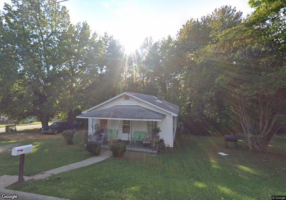
1034 Asheboro St High Point, NC 27260
Greater High Point NeighborhoodEstimated Value: $84,700 - $177,000
2
Beds
1
Bath
900
Sq Ft
$156/Sq Ft
Est. Value
About This Home
This home is located at 1034 Asheboro St, High Point, NC 27260 and is currently estimated at $140,175, approximately $155 per square foot. 1034 Asheboro St is a home located in Guilford County with nearby schools including Fairview Elementary School, Ferndale Middle School, and High Point Central High School.
Ownership History
Date
Name
Owned For
Owner Type
Purchase Details
Closed on
May 25, 2021
Sold by
Bowers David Wayne and Marie Lawing Bowers Trust
Bought by
Rhymer Albert Daniel
Current Estimated Value
Home Financials for this Owner
Home Financials are based on the most recent Mortgage that was taken out on this home.
Original Mortgage
$33,756
Outstanding Balance
$25,508
Interest Rate
3%
Mortgage Type
Purchase Money Mortgage
Estimated Equity
$114,667
Purchase Details
Closed on
Oct 19, 2018
Sold by
Lawing Bowers Marie and Bowers Marie L
Bought by
Bowers David Wayne and The Marie Lawing Bowers Trust
Create a Home Valuation Report for This Property
The Home Valuation Report is an in-depth analysis detailing your home's value as well as a comparison with similar homes in the area
Home Values in the Area
Average Home Value in this Area
Purchase History
| Date | Buyer | Sale Price | Title Company |
|---|---|---|---|
| Rhymer Albert Daniel | $35,000 | None Available | |
| Bowers David Wayne | -- | None Available |
Source: Public Records
Mortgage History
| Date | Status | Borrower | Loan Amount |
|---|---|---|---|
| Open | Rhymer Albert Daniel | $33,756 |
Source: Public Records
Tax History
| Year | Tax Paid | Tax Assessment Tax Assessment Total Assessment is a certain percentage of the fair market value that is determined by local assessors to be the total taxable value of land and additions on the property. | Land | Improvement |
|---|---|---|---|---|
| 2025 | $469 | $34,000 | $8,000 | $26,000 |
| 2024 | $469 | $34,000 | $8,000 | $26,000 |
| 2023 | $469 | $34,000 | $8,000 | $26,000 |
| 2022 | $458 | $34,000 | $8,000 | $26,000 |
| 2021 | $329 | $23,900 | $5,000 | $18,900 |
| 2020 | $329 | $23,900 | $5,000 | $18,900 |
| 2019 | $329 | $23,900 | $0 | $0 |
| 2018 | $328 | $23,900 | $0 | $0 |
| 2017 | $328 | $23,900 | $0 | $0 |
| 2016 | $302 | $21,500 | $0 | $0 |
| 2015 | $303 | $21,500 | $0 | $0 |
| 2014 | $308 | $21,500 | $0 | $0 |
Source: Public Records
Map
Nearby Homes
- 925 Randolph St
- 1021 Asheboro St
- 1010 Grace St
- 909 Randolph St
- 1015 Sharon St
- 1114 Richland St
- 705 Wise Ave
- 1012 Jefferson St
- 1103 Jefferson St
- 702 Park St
- 507 E Grimes Ave
- 423 Tate St
- 812 E Russell Ave
- 1422 Valley Ridge Dr
- 1309 Pershing St
- 650 Wesley Dr
- 640 Wesley Dr
- 1217 Cloverdale St
- 809 E Green Dr
- 526 White Oak St
- 1030 Asheboro St
- 1028 Asheboro St
- 1028 Asheboro St Unit B
- 1028 Asheboro St Unit A
- 929 Randolph St
- 931 Randolph St
- 933 Randolph St
- 927 Randolph St
- 1102 Asheboro St
- 1033 Asheboro St
- 1031 Asheboro St
- 1029 Asheboro St
- 1035 Asheboro St
- 704 Lake Ave
- 1020 Asheboro St
- 1025 Asheboro St
- 923 Randolph St
- 800 Lake Ave
- 702 Lake Ave
- 1023 Asheboro St
Your Personal Tour Guide
Ask me questions while you tour the home.