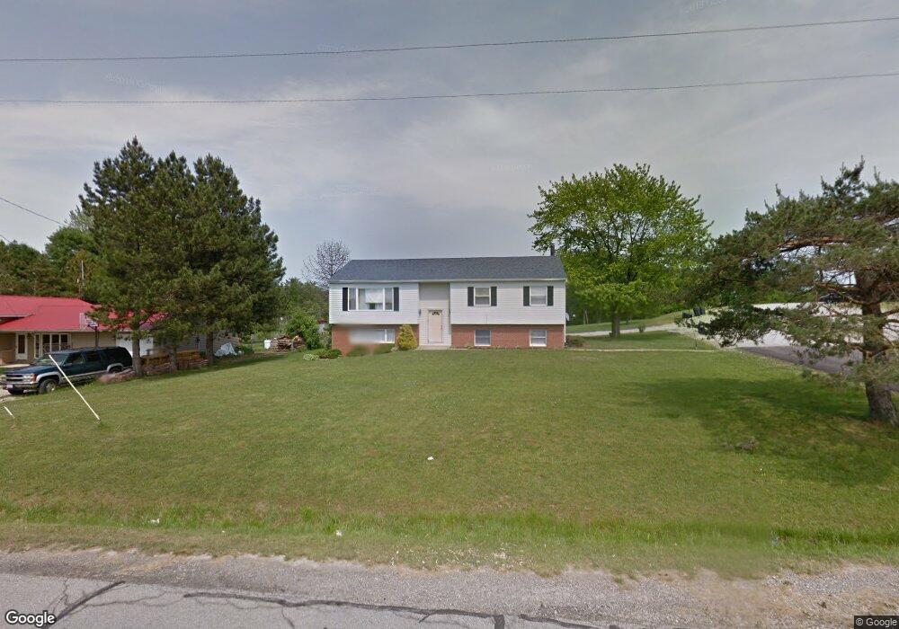
1034 Walcrest Dr Mansfield, OH 44903
Estimated Value: $183,000 - $296,882
4
Beds
3
Baths
2,253
Sq Ft
$99/Sq Ft
Est. Value
About This Home
This home is located at 1034 Walcrest Dr, Mansfield, OH 44903 and is currently estimated at $221,971, approximately $98 per square foot. 1034 Walcrest Dr is a home located in Richland County with nearby schools including Stingel Elementary School, Ontario Middle School, and Ontario High School.
Ownership History
Date
Name
Owned For
Owner Type
Purchase Details
Closed on
Oct 30, 2024
Sold by
Hesed Agape Ministries Intl and New Mercy Ministries
Bought by
New Mercy Outreach Inc
Current Estimated Value
Home Financials for this Owner
Home Financials are based on the most recent Mortgage that was taken out on this home.
Original Mortgage
$244,100
Outstanding Balance
$238,770
Interest Rate
6.12%
Mortgage Type
New Conventional
Estimated Equity
-$16,799
Create a Home Valuation Report for This Property
The Home Valuation Report is an in-depth analysis detailing your home's value as well as a comparison with similar homes in the area
Home Values in the Area
Average Home Value in this Area
Purchase History
| Date | Buyer | Sale Price | Title Company |
|---|---|---|---|
| New Mercy Outreach Inc | $180,000 | Great American Title | |
| New Mercy Outreach Inc | $180,000 | Great American Title |
Source: Public Records
Mortgage History
| Date | Status | Borrower | Loan Amount |
|---|---|---|---|
| Open | New Mercy Outreach Inc | $244,100 | |
| Closed | New Mercy Outreach Inc | $244,100 |
Source: Public Records
Tax History
| Year | Tax Paid | Tax Assessment Tax Assessment Total Assessment is a certain percentage of the fair market value that is determined by local assessors to be the total taxable value of land and additions on the property. | Land | Improvement |
|---|---|---|---|---|
| 2024 | $2,858 | $55,070 | $8,630 | $46,440 |
| 2023 | $2,851 | $55,070 | $8,630 | $46,440 |
| 2022 | $2,706 | $44,990 | $7,850 | $37,140 |
| 2021 | $2,711 | $44,990 | $7,850 | $37,140 |
| 2020 | $2,892 | $44,990 | $7,850 | $37,140 |
| 2019 | $2,713 | $38,390 | $6,650 | $31,740 |
| 2018 | $2,322 | $38,390 | $6,650 | $31,740 |
| 2017 | $2,287 | $38,390 | $6,650 | $31,740 |
| 2016 | $2,288 | $38,190 | $6,450 | $31,740 |
| 2015 | $2,288 | $38,190 | $6,450 | $31,740 |
| 2014 | $2,286 | $38,190 | $6,450 | $31,740 |
| 2012 | $2,149 | $39,370 | $6,650 | $32,720 |
Source: Public Records
Map
Nearby Homes
- 3872 Snodgrass Rd
- 1689 Ohio 314
- 3767 Cookton Grange Rd
- 0 Rudy Rd
- 15 Lexington Ontario Rd
- 3880 Horizon Dr
- 2990 Hemlock Place
- 3308 Park Ave W
- 3320 Oakstone Dr
- 5263 Lincoln Hwy
- 3516 Muirfield
- 3516 Muirfield Dr
- 4822 Flowers Rd
- 0 Rock Rd
- 5446 Lincoln Hwy
- 683 Yeager Dr
- 2583 Deerfield Ln
- 1260 Thrush Rd
- 1111 Bogey Dr
- 1114 Bogey Dr Unit 1114
- 1044 Walcrest Dr
- 1035 Walcrest Dr
- 1064 Walcrest Dr
- 1055 Walcrest Dr
- 1074 Walcrest Dr
- 1065 Walcrest Dr
- 1075 Walcrest Dr
- 1085 Walcrest Dr
- 1094 Walcrest Dr
- 1104 Walcrest Dr
- 1105 Walcrest Dr
- 1114 Walcrest Dr
- 4151 W 4th St
- 1115 Walcrest Dr
- 4174 W 4th St
- 4025 Snodgrass Rd
- 1124 Walcrest Dr
- 4173 W 4th St
- 4115 Snodgrass Rd
- 4115 Snodgrass Rd
Your Personal Tour Guide
Ask me questions while you tour the home.