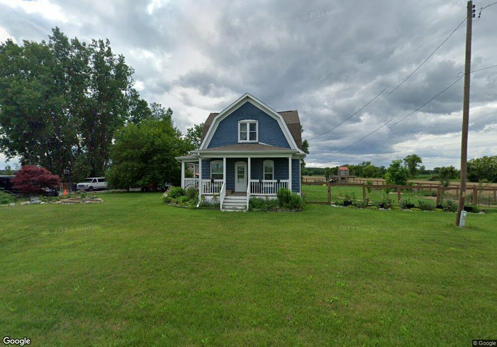
10345 Carter Rd Freeland, MI 48623
Estimated Value: $192,399 - $299,000
3
Beds
1
Bath
1,920
Sq Ft
$127/Sq Ft
Est. Value
About This Home
This home is located at 10345 Carter Rd, Freeland, MI 48623 and is currently estimated at $243,600, approximately $126 per square foot. 10345 Carter Rd is a home located in Saginaw County with nearby schools including Freeland Learning Center, Freeland Elementary School, and Freeland Middle/High School.
Ownership History
Date
Name
Owned For
Owner Type
Purchase Details
Closed on
Oct 14, 2019
Sold by
Klopf Andrea and Klopf Garry A
Bought by
Klopf Andrea and Klopf Garry A
Current Estimated Value
Home Financials for this Owner
Home Financials are based on the most recent Mortgage that was taken out on this home.
Original Mortgage
$57,500
Outstanding Balance
$49,975
Interest Rate
3.5%
Mortgage Type
New Conventional
Estimated Equity
$193,625
Purchase Details
Closed on
Jul 18, 2012
Sold by
Donahue Rickey
Bought by
Klopf Andrea
Create a Home Valuation Report for This Property
The Home Valuation Report is an in-depth analysis detailing your home's value as well as a comparison with similar homes in the area
Home Values in the Area
Average Home Value in this Area
Purchase History
| Date | Buyer | Sale Price | Title Company |
|---|---|---|---|
| Klopf Andrea | -- | None Available | |
| Klopf Andrea | $10,000 | -- |
Source: Public Records
Mortgage History
| Date | Status | Borrower | Loan Amount |
|---|---|---|---|
| Open | Klopf Andrea | $57,500 |
Source: Public Records
Tax History Compared to Growth
Tax History
| Year | Tax Paid | Tax Assessment Tax Assessment Total Assessment is a certain percentage of the fair market value that is determined by local assessors to be the total taxable value of land and additions on the property. | Land | Improvement |
|---|---|---|---|---|
| 2025 | $2,024 | $85,400 | $0 | $0 |
| 2024 | $548 | $78,900 | $0 | $0 |
| 2023 | $521 | $84,400 | $0 | $0 |
| 2022 | $1,676 | $78,000 | $0 | $0 |
| 2021 | $1,530 | $64,700 | $0 | $0 |
| 2020 | $1,172 | $38,300 | $0 | $0 |
| 2019 | $1,130 | $32,400 | $0 | $0 |
| 2018 | $376 | $34,600 | $0 | $0 |
| 2017 | $1,092 | $33,600 | $0 | $0 |
| 2016 | $1,109 | $34,400 | $0 | $0 |
| 2014 | -- | $34,000 | $0 | $24,500 |
| 2013 | -- | $33,800 | $0 | $0 |
Source: Public Records
Map
Nearby Homes
- 10832 Carter Rd
- 10399 Webster Rd
- 8981 Highland Dr
- 10585 Prairie View Ct
- 5749 11 Mile Rd
- 8884 Copper Ct
- 0 Foxtail Trail Unit 50182332
- 8657 Foxtail Trail
- 8630 Foxtail Trail
- 8483 N River Rock River Rock Unit 8487
- 8599 Ashland Place
- 8535 Summer Ridge Dr
- 9924 Garner Ln
- 5 Willow Point Dr
- 8442 Cottonwood Dr
- 12422 Northway Pkwy
- 12449 Northway Pkwy
- 8421 Waxwing Dr
- 8183 N River Rd
- 8611 Winding Brook Cir
- 10390 Carter Rd
- 10414 Carter Rd
- 10460 Carter Rd
- 10465 Carter Rd
- 10145 Carter Rd
- 10145 Carter Rd
- 10410 Carter Rd
- 10100 Carter Rd
- 10100 Carter Rd
- 10085 Carter Rd
- 10570 Carter Rd
- 10585 Carter Rd
- 10632 Carter Rd
- 10016 Carter Rd
- 10680 Carter
- 10680 Carter
- 10680 Carter Rd
- 10680 Carter Rd
- 10680 Carter Rd
- 10566 Carter Rd