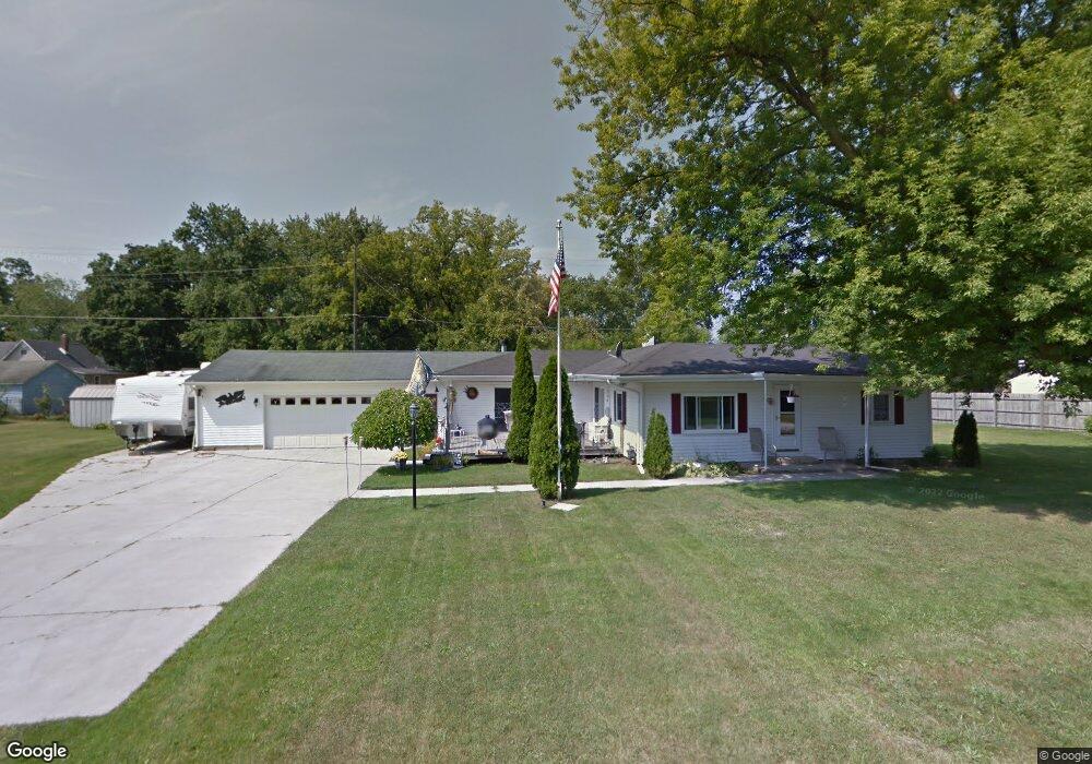
1035 40th St Port Huron, MI 48060
Estimated Value: $170,000 - $228,000
2
Beds
2
Baths
1,523
Sq Ft
$133/Sq Ft
Est. Value
About This Home
This home is located at 1035 40th St, Port Huron, MI 48060 and is currently estimated at $202,803, approximately $133 per square foot. 1035 40th St is a home located in St. Clair County with nearby schools including Kimball Elementary School, Central Middle School, and Port Huron High School.
Ownership History
Date
Name
Owned For
Owner Type
Purchase Details
Closed on
Jul 30, 2020
Sold by
James Nalepa Dennis and James Jean M
Bought by
Seals Susan Marie
Current Estimated Value
Home Financials for this Owner
Home Financials are based on the most recent Mortgage that was taken out on this home.
Original Mortgage
$111,920
Outstanding Balance
$99,022
Interest Rate
3.1%
Mortgage Type
New Conventional
Estimated Equity
$103,781
Create a Home Valuation Report for This Property
The Home Valuation Report is an in-depth analysis detailing your home's value as well as a comparison with similar homes in the area
Home Values in the Area
Average Home Value in this Area
Purchase History
| Date | Buyer | Sale Price | Title Company |
|---|---|---|---|
| Seals Susan Marie | $139,900 | Liberty Title |
Source: Public Records
Mortgage History
| Date | Status | Borrower | Loan Amount |
|---|---|---|---|
| Open | Seals Susan Marie | $111,920 |
Source: Public Records
Tax History Compared to Growth
Tax History
| Year | Tax Paid | Tax Assessment Tax Assessment Total Assessment is a certain percentage of the fair market value that is determined by local assessors to be the total taxable value of land and additions on the property. | Land | Improvement |
|---|---|---|---|---|
| 2025 | $2,207 | $90,400 | $0 | $0 |
| 2024 | $1,126 | $70,600 | $0 | $0 |
| 2023 | $1,039 | $65,400 | $0 | $0 |
| 2022 | $1,920 | $55,100 | $0 | $0 |
| 2021 | $1,302 | $53,800 | $0 | $0 |
| 2020 | $1,302 | $56,200 | $56,200 | $0 |
| 2019 | $1,378 | $45,400 | $0 | $0 |
| 2018 | $1,314 | $45,400 | $0 | $0 |
| 2017 | $1,289 | $44,900 | $0 | $0 |
| 2016 | $632 | $44,900 | $0 | $0 |
| 2015 | -- | $37,600 | $37,600 | $0 |
| 2014 | -- | $36,600 | $36,600 | $0 |
| 2013 | -- | $35,400 | $0 | $0 |
Source: Public Records
Map
Nearby Homes
- 0 39th St Unit 25046693
- 0 39th St Unit 20251028136
- 3333 Ravenswood Rd Unit 4A
- 3333 Ravenswood Rd
- V/L Michigan
- 00 Moak St
- 000 Gratiot Blvd
- 00 Gratiot Blvd
- 69 Gratiot Blvd
- 0 Busha Hwy Unit 50194246
- 104 Oldbrook Ln
- 3548 Cleveland St
- 0000 Wisconsin Ave
- 153 Meadow Ln
- 3830 Military St
- 42 Liberty Ave
- 174 Meadow Ln
- 2702 Vanness St
- 3369 Dove Rd
- 2600 Vanness St
- 1045 40th St
- 3604 Ravenswood Rd
- 3614 Ravenswood Rd
- 3620 Ravenswood Rd
- 3580 Ravenswood Rd
- 3560 Ravenswood Rd
- 3636 Ravenswood Rd
- 3644 Ravenswood Rd
- 3550 Ravenswood Rd
- 0 40th St Unit 212022493
- 0 40th St Unit 31347894
- 0 40th St Unit 4959381
- 0 40th St Unit 4218048
- 0 40th St Unit 4969163
- 0 40th St Unit 4425667
- 0 40th St Unit 4544330
- 0 40th St Unit 31038963
- 0 40th St Unit 211002606
- 0 40th St Unit 31093153
- 0 40th St Unit 31168074