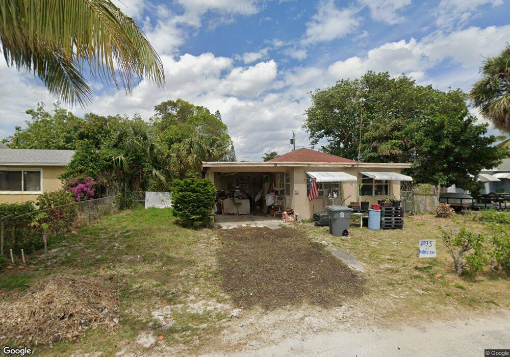
1035 Highview Rd Lantana, FL 33462
San Castle NeighborhoodEstimated Value: $280,009 - $313,000
2
Beds
1
Bath
840
Sq Ft
$350/Sq Ft
Est. Value
About This Home
This home is located at 1035 Highview Rd, Lantana, FL 33462 and is currently estimated at $294,002, approximately $350 per square foot. 1035 Highview Rd is a home located in Palm Beach County with nearby schools including Rolling Green Elementary School, Boynton Beach Community High School, and Congress Community Middle School.
Ownership History
Date
Name
Owned For
Owner Type
Purchase Details
Closed on
Jun 18, 2024
Sold by
Thompson Richard N and Thompson Bettye J
Bought by
Richard N Thompson And Bettye J Thompson Revo and Thompson
Current Estimated Value
Purchase Details
Closed on
Apr 30, 2009
Sold by
Thompson Bettye J
Bought by
Thompson Richard N and Thompson Bettye J
Purchase Details
Closed on
Dec 2, 1997
Sold by
Turpin Clarence W and Turpin Lisette
Bought by
Thompson Bettye J
Create a Home Valuation Report for This Property
The Home Valuation Report is an in-depth analysis detailing your home's value as well as a comparison with similar homes in the area
Home Values in the Area
Average Home Value in this Area
Purchase History
| Date | Buyer | Sale Price | Title Company |
|---|---|---|---|
| Richard N Thompson And Bettye J Thompson Revo | -- | None Listed On Document | |
| Thompson Richard N | -- | Attorney | |
| Thompson Bettye J | $100 | -- |
Source: Public Records
Tax History
| Year | Tax Paid | Tax Assessment Tax Assessment Total Assessment is a certain percentage of the fair market value that is determined by local assessors to be the total taxable value of land and additions on the property. | Land | Improvement |
|---|---|---|---|---|
| 2025 | $2,325 | $85,828 | -- | -- |
| 2024 | $2,325 | $78,025 | -- | -- |
| 2023 | $2,109 | $70,932 | $81,604 | $76,430 |
| 2022 | $2,086 | $64,484 | $0 | $0 |
| 2021 | $1,762 | $115,529 | $52,000 | $63,529 |
| 2020 | $1,738 | $118,941 | $66,000 | $52,941 |
| 2019 | $1,577 | $100,407 | $44,000 | $56,407 |
| 2018 | $1,360 | $83,259 | $22,315 | $60,944 |
| 2017 | $1,234 | $72,121 | $13,947 | $58,174 |
| 2016 | $1,134 | $36,400 | $0 | $0 |
| 2015 | $1,096 | $33,091 | $0 | $0 |
| 2014 | $988 | $30,083 | $0 | $0 |
Source: Public Records
Map
Nearby Homes
- 1078 Peak Rd
- 1079 Highview Rd
- 1093 Highview Rd
- 7874 Griswold St
- 945 Miner Rd
- 7945 Loomis St
- 644 Waterside Dr
- 1214 Peak Rd
- 7937 Coral St
- 1206 S Ridge Rd
- 8090 Ambach Way Unit B
- 700 Waterside Dr
- 164 Waterside Dr
- 169 Waterside Dr
- 3313 Grove Rd
- 3041 E Palm Dr
- 8130 Ambach Way Unit 8B
- 520 Seagrape Rd
- 120 Via Villagio
- 232 Waterside Dr
- 1043 Highview Rd
- 7839 Overlook Rd
- 1034 Peak Rd
- 1028 Peak Rd
- 1049 Highview Rd
- 1014 Peak Rd
- 1014 Peak Rd
- 1042 Peak Rd
- 1010 Peak Rd
- 1028 Highview Rd
- 1050 Peak Rd
- 1057 Highview Rd
- 1020 Highview Rd
- 1042 Highview Rd
- 1050 Highview Rd
- 7842 Overlook Rd
- 7826 Overlook Rd
- 7852 Overlook Rd
- 1064 Highview Rd
- 7862 Overlook Rd
Your Personal Tour Guide
Ask me questions while you tour the home.