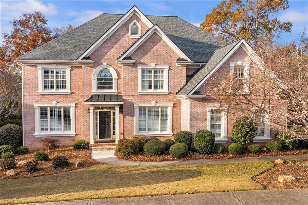

1035 Lainston Ct Alpharetta, GA 30022
Estimated payment $7,335/month
Highlights
- Fitness Center
- Media Room
- Community Lake
- New Prospect Elementary School Rated A
- View of Trees or Woods
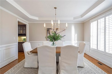
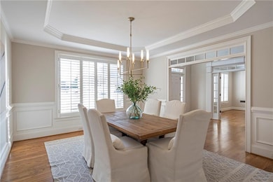
- Dining Room Seats More Than Twelve
About This Home
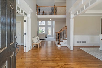
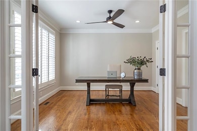
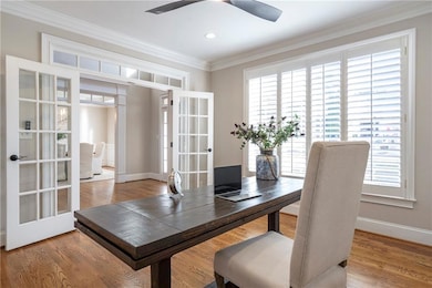
STUNNING HOME IN GLEN ABBEY! Discover the ultimate lifestyle in this magnificent 6-bedroom, 6-bath residence spanning 6,000 sq ft, perfectly tucked away on an ultra-private cul-de-sac street! This home offers tranquility while delivering immediate access to the premier amenities of the Glen Abbey community. Walk in and be captivated by this meticulously maintained home, including a new roof (2023), fresh interior paint throughout, and new carpet in the expansive Great Room. Practical luxury starts with the side-entry three-car garage and the convenient "friends' entrance" into the mudroom and kitchen. The heart of the home is the large Gourmet Kitchen, a true chef's dream featuring double ovens, a gas cooktop, and a walk-in pantry. This space is designed for entertaining, seamlessly flowing into a sunny eat-in kitchen and a cozy Keeping Room with a fireplace—perfect for family relaxation. The expansive floorplan ensures comfort for all, featuring four dedicated upstairs bedroom suites, each boasting a private, full en-suite bath. The main level includes a flexible Executive Office or Guest Suite with convenient access to the main full bath. The fully finished terrace level is an incredible asset for year-round enjoyment, featuring a wet bar, spacious game room, dedicated exercise room, a private sixth bedroom and a full bath, plus extensive storage with smart built-in shelving. Step outside to your private retreat: a fully fenced backyard with an impressive, serene wooded view. Enjoy the resort-style Glen Abbey amenities: 10 lighted Tennis Courts, Pickleball courts, Swimming Pool, Clubhouse with a Fitness Center, Playground, Community Lake, and Sidewalks. This coveted neighborhood address is zoned for award-winning Alpharetta High School and is moments from the Greenway walking path, Avalon & Downtown Alpharetta's dining, shopping and entertainment with easy access to GA 400! Don't miss the opportunity to make this amazing estate your home!
Home Details
Home Type
- Single Family
Est. Annual Taxes
- $7,378
Year Built
- Built in 2001
Lot Details
- 0.54 Acre Lot
- Cul-De-Sac
- Private Entrance
- Property has an invisible fence for dogs
- Landscaped
- Level Lot
- Irrigation Equipment
- Wooded Lot
- Back Yard Fenced and Front Yard
HOA Fees
- $138 Monthly HOA Fees
Parking
- 3 Car Attached Garage
- Driveway
Home Design
- Traditional Architecture
- Composition Roof
- Three Sided Brick Exterior Elevation
- Concrete Perimeter Foundation
- HardiePlank Type
Interior Spaces
- 2-Story Property
- Wet Bar
- Bookcases
- Crown Molding
- Tray Ceiling
- Ceiling height of 9 feet on the lower level
- Ceiling Fan
- Recessed Lighting
- Gas Log Fireplace
- Double Pane Windows
- Plantation Shutters
- Wood Frame Window
- Mud Room
- Two Story Entrance Foyer
- Family Room with Fireplace
- 3 Fireplaces
- Great Room with Fireplace
- Dining Room Seats More Than Twelve
- Breakfast Room
- Media Room
- Home Office
- Library
- Keeping Room with Fireplace
- Home Gym
- Views of Woods
- Pull Down Stairs to Attic
- Fire and Smoke Detector
Kitchen
- Open to Family Room
- Eat-In Kitchen
- Breakfast Bar
- Walk-In Pantry
- Butlers Pantry
- Double Self-Cleaning Oven
- Gas Cooktop
- Microwave
- Dishwasher
- ENERGY STAR Qualified Appliances
- Kitchen Island
- Stone Countertops
- Wood Stained Kitchen Cabinets
- Wine Rack
- Disposal
Flooring
- Wood
- Carpet
- Ceramic Tile
Bedrooms and Bathrooms
- Oversized primary bedroom
- Fireplace in Primary Bedroom
- Walk-In Closet
- Dual Vanity Sinks in Primary Bathroom
- Low Flow Plumbing Fixtures
- Whirlpool Bathtub
- Separate Shower in Primary Bathroom
Laundry
- Laundry in Mud Room
- Laundry Room
- Laundry on main level
- Sink Near Laundry
- 220 Volts In Laundry
- Electric Dryer Hookup
Finished Basement
- Walk-Out Basement
- Basement Fills Entire Space Under The House
- Exterior Basement Entry
- Finished Basement Bathroom
- Natural lighting in basement
Outdoor Features
- Deck
- Covered Patio or Porch
Schools
- New Prospect Elementary School
- Webb Bridge Middle School
- Alpharetta High School
Utilities
- Forced Air Zoned Heating and Cooling System
- Air Source Heat Pump
- Heating System Uses Natural Gas
- Underground Utilities
- 220 Volts
- 110 Volts
- ENERGY STAR Qualified Water Heater
- Gas Water Heater
- Phone Available
- Cable TV Available
Additional Features
- ENERGY STAR Qualified Equipment
- Property is near shops
Listing and Financial Details
- Assessor Parcel Number 11 015000432224
Community Details
Overview
- $2,000 Initiation Fee
- Glen Abbey Subdivision
- Rental Restrictions
- Community Lake
Amenities
- Clubhouse
Recreation
- Tennis Courts
- Pickleball Courts
- Community Playground
- Swim Team
- Fitness Center
- Community Pool
- Trails
Map
Home Values in the Area
Average Home Value in this Area
Tax History
| Year | Tax Paid | Tax Assessment Tax Assessment Total Assessment is a certain percentage of the fair market value that is determined by local assessors to be the total taxable value of land and additions on the property. | Land | Improvement |
|---|---|---|---|---|
| 2025 | $1,521 | $438,600 | $153,760 | $284,840 |
| 2023 | $10,872 | $385,160 | $101,160 | $284,000 |
| 2022 | $6,771 | $311,760 | $74,280 | $237,480 |
| 2021 | $8,071 | $280,680 | $74,120 | $206,560 |
| 2020 | $8,128 | $281,680 | $56,480 | $225,200 |
| 2019 | $1,303 | $276,680 | $55,480 | $221,200 |
| 2018 | $6,974 | $270,200 | $54,160 | $216,040 |
| 2017 | $6,721 | $246,440 | $57,080 | $189,360 |
| 2016 | $6,688 | $246,440 | $57,080 | $189,360 |
| 2015 | $7,930 | $246,440 | $57,080 | $189,360 |
| 2014 | $6,621 | $229,280 | $53,120 | $176,160 |
Property History
| Date | Event | Price | List to Sale | Price per Sq Ft |
|---|---|---|---|---|
| 11/19/2025 11/19/25 | Pending | -- | -- | -- |
| 11/15/2025 11/15/25 | For Sale | $1,250,000 | -- | $297 / Sq Ft |
Purchase History
| Date | Type | Sale Price | Title Company |
|---|---|---|---|
| Warranty Deed | -- | -- | |
| Quit Claim Deed | -- | -- | |
| Deed | $519,900 | -- |
Mortgage History
| Date | Status | Loan Amount | Loan Type |
|---|---|---|---|
| Previous Owner | $295,000 | New Conventional |
Source: First Multiple Listing Service (FMLS)
MLS Number: 7679510
APN: 11-0150-0043-222-4
Disclaimer: Certain information contained herein is derived from information provided by parties other than Homes.com. All information provided is deemed reliable, but is not guaranteed to be accurate and should be independently verified.
![]() Listings identified with the FMLS IDX logo come from FMLS and are held by brokerage firms other than the owner of this website. The listing brokerage is identified in any listing details. Information is deemed reliable but is not guaranteed. If you believe any FMLS listing contains material that infringes your copyrighted work please visit www.fmls.com/dmca to review our DMCA policy and learn how to submit a takedown request. © 2025 First Multiple Listing Service, Inc.
Listings identified with the FMLS IDX logo come from FMLS and are held by brokerage firms other than the owner of this website. The listing brokerage is identified in any listing details. Information is deemed reliable but is not guaranteed. If you believe any FMLS listing contains material that infringes your copyrighted work please visit www.fmls.com/dmca to review our DMCA policy and learn how to submit a takedown request. © 2025 First Multiple Listing Service, Inc.
- 870 Longstone Landing
- 5008 Avalon Dr
- 11640 Folia Cir
- 3087 Camden Way
- 3015 Camden Way
- 4345 Park Brooke Trace
- 3027 Camden Way
- 3010 Brooke View Ct Unit 5
- 2040 Whitestone Place Unit 71
- 1005 Whitestone Ridge
- 4465 Park Brooke Trace Unit 5
- 3965 Brookline Dr
- 10900 Wittenridge Dr Unit I3
- 10900 Wittenridge Dr Unit H8
- 10900 Wittenridge Dr Unit C7
- 345 Kincardine Way Unit IIIA
- 3962 Erin Dr
- 535 Tumbling Creek Dr Unit 6
