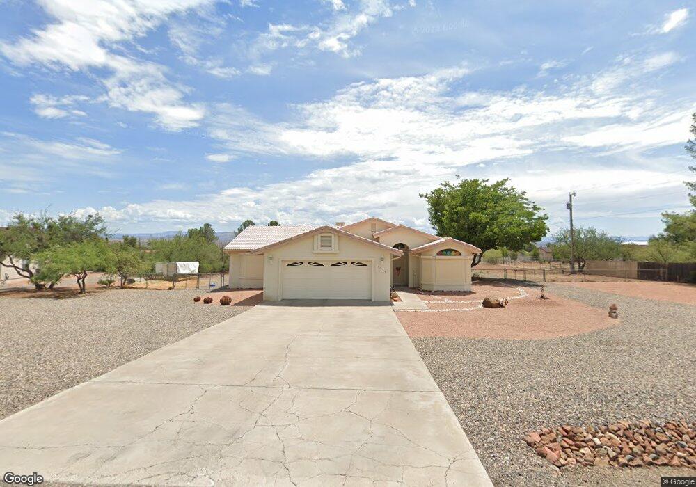
1035 S 8th St Cottonwood, AZ 86326
Cottonwood NeighborhoodEstimated Value: $610,977 - $846,000
3
Beds
--
Bath
2,182
Sq Ft
$330/Sq Ft
Est. Value
About This Home
This home is located at 1035 S 8th St, Cottonwood, AZ 86326 and is currently estimated at $719,994, approximately $329 per square foot. 1035 S 8th St is a home located in Yavapai County with nearby schools including Dr Daniel Bright Elementary School, Cottonwood Elementary School, and Cottonwood Community School.
Ownership History
Date
Name
Owned For
Owner Type
Purchase Details
Closed on
Nov 21, 2024
Sold by
Duncan Virginia I
Bought by
V Duncan Trust and Duncan
Current Estimated Value
Purchase Details
Closed on
Mar 28, 2001
Sold by
Ogg Rick D and Ogg Kathleen A
Bought by
Duncan Richard V and Duncan Virginia I
Purchase Details
Closed on
Mar 27, 1995
Sold by
Millar Stephen R and Millar Shirley R
Bought by
Ogg Rick D and Ogg Kathleen A
Home Financials for this Owner
Home Financials are based on the most recent Mortgage that was taken out on this home.
Original Mortgage
$85,000
Interest Rate
8.81%
Mortgage Type
New Conventional
Purchase Details
Closed on
Jan 6, 1994
Sold by
Hodgson Robert A and Hodgson Mona J
Bought by
Millar Stephen R and Millar Shirley R
Create a Home Valuation Report for This Property
The Home Valuation Report is an in-depth analysis detailing your home's value as well as a comparison with similar homes in the area
Home Values in the Area
Average Home Value in this Area
Purchase History
| Date | Buyer | Sale Price | Title Company |
|---|---|---|---|
| V Duncan Trust | -- | None Listed On Document | |
| Duncan Richard V | $229,000 | First American Title | |
| Ogg Rick D | $170,000 | First American Title Ins | |
| Millar Stephen R | $26,500 | First American Title Ins Co |
Source: Public Records
Mortgage History
| Date | Status | Borrower | Loan Amount |
|---|---|---|---|
| Previous Owner | Ogg Rick D | $85,000 |
Source: Public Records
Tax History Compared to Growth
Tax History
| Year | Tax Paid | Tax Assessment Tax Assessment Total Assessment is a certain percentage of the fair market value that is determined by local assessors to be the total taxable value of land and additions on the property. | Land | Improvement |
|---|---|---|---|---|
| 2026 | $1,867 | $65,639 | -- | -- |
| 2024 | $1,829 | $66,257 | -- | -- |
| 2023 | $1,829 | $54,350 | $8,327 | $46,023 |
| 2022 | $1,824 | $44,760 | $6,964 | $37,796 |
| 2021 | $1,983 | $40,652 | $6,124 | $34,528 |
| 2020 | $1,970 | $0 | $0 | $0 |
| 2019 | $1,958 | $0 | $0 | $0 |
| 2018 | $1,881 | $0 | $0 | $0 |
| 2017 | $1,802 | $0 | $0 | $0 |
| 2016 | $1,771 | $0 | $0 | $0 |
| 2015 | -- | $0 | $0 | $0 |
| 2014 | -- | $0 | $0 | $0 |
Source: Public Records
Map
Nearby Homes
- 630 E Elm St
- 1295 E Ridgeview Dr
- 1798 E Fir St
- 912 S 6th St
- 1322 E Five Star Blvd
- 1860 Sunset Dr
- 1520 E Elm St
- 1041 S Vista Grande Dr
- 1203 S Settlers Cir
- 320 E Fir St
- 1615 E Crestview Cir
- 1161 S 10th St
- 1191 S Vista Grande Dr
- 421 Boulder Ln
- 1063 S Viejo Dr
- 1059 S 16th Place
- 910 S Tigres Trail
- 1476 S Verde Dr
- 1151 E State Route 89a --
- 1655 Oro Dr