Estimated Value: $716,000 - $796,000
6
Beds
5
Baths
4,768
Sq Ft
$159/Sq Ft
Est. Value
About This Home
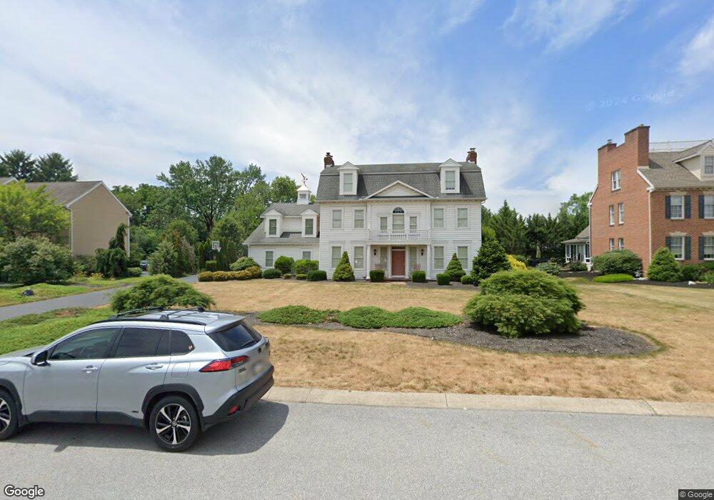
This home is located at 1035 Wetherburn Dr, York, PA 17404 and is currently estimated at $759,374, approximately $159 per square foot. 1035 Wetherburn Dr is a home located in York County with nearby schools including Central York High School, Christian School of York, and York Adventist Christian School.
Ownership History
Date
Name
Owned For
Owner Type
Purchase Details
Closed on
Jan 14, 2013
Sold by
Laning Wayne and Laning Dewanna
Bought by
Laning Wayne
Current Estimated Value
Purchase Details
Closed on
Aug 31, 2004
Sold by
Daniels Robin A Thorn and Daniels Justin
Bought by
Laning Wayne and Laning Dewanna
Home Financials for this Owner
Home Financials are based on the most recent Mortgage that was taken out on this home.
Original Mortgage
$217,000
Outstanding Balance
$108,438
Interest Rate
6.01%
Mortgage Type
Purchase Money Mortgage
Estimated Equity
$650,936
Purchase Details
Closed on
Nov 15, 2000
Sold by
Marino Richard A and Marino Teresa A
Bought by
Thorn Robin A
Home Financials for this Owner
Home Financials are based on the most recent Mortgage that was taken out on this home.
Original Mortgage
$339,920
Interest Rate
7.75%
Purchase Details
Closed on
Oct 20, 1998
Sold by
Warner Robert E and Warner Jeanne C
Bought by
Marino Richard A and Marino Teresa A
Home Financials for this Owner
Home Financials are based on the most recent Mortgage that was taken out on this home.
Original Mortgage
$288,000
Interest Rate
6.65%
Create a Home Valuation Report for This Property
The Home Valuation Report is an in-depth analysis detailing your home's value as well as a comparison with similar homes in the area
Home Values in the Area
Average Home Value in this Area
Purchase History
| Date | Buyer | Sale Price | Title Company |
|---|---|---|---|
| Laning Wayne | -- | None Available | |
| Laning Wayne | $482,000 | Chicago Title Insurance Comp | |
| Thorn Robin A | $424,900 | -- | |
| Marino Richard A | $360,000 | -- |
Source: Public Records
Mortgage History
| Date | Status | Borrower | Loan Amount |
|---|---|---|---|
| Open | Laning Wayne | $217,000 | |
| Previous Owner | Thorn Robin A | $339,920 | |
| Previous Owner | Marino Richard A | $288,000 |
Source: Public Records
Tax History Compared to Growth
Tax History
| Year | Tax Paid | Tax Assessment Tax Assessment Total Assessment is a certain percentage of the fair market value that is determined by local assessors to be the total taxable value of land and additions on the property. | Land | Improvement |
|---|---|---|---|---|
| 2025 | $13,874 | $452,740 | $65,960 | $386,780 |
| 2024 | $13,478 | $452,740 | $65,960 | $386,780 |
| 2023 | $12,989 | $452,740 | $65,960 | $386,780 |
| 2022 | $12,781 | $452,740 | $65,960 | $386,780 |
| 2021 | $12,328 | $452,740 | $65,960 | $386,780 |
| 2020 | $12,328 | $452,740 | $65,960 | $386,780 |
| 2019 | $12,102 | $452,740 | $65,960 | $386,780 |
| 2018 | $11,839 | $452,740 | $65,960 | $386,780 |
| 2017 | $11,644 | $452,740 | $65,960 | $386,780 |
| 2016 | $0 | $452,740 | $65,960 | $386,780 |
| 2015 | -- | $440,660 | $65,960 | $374,700 |
| 2014 | -- | $440,660 | $65,960 | $374,700 |
Source: Public Records
Map
Nearby Homes
- 1055 Wetherburn Dr
- 15 Wetherburn Ct
- 2547 Hepplewhite Dr
- 1005 Gleneagles Dr
- 929 Bedford Rd
- 1305 Detwiler Dr
- 2611 Oberlin Dr
- 1300 Garrison Dr
- 1375 Detwiler Dr
- 1350 Briargate Dr
- 1425 Brittany Dr
- Lot 3 Parkwood Dr
- 2919 Sloane Cir Unit 10
- Lot 3 Fenwick Model Parkwood Dr
- Lot 3 St. Michaels M Parkwood Dr
- 3305 Bitternut Blvd
- 2455 Brandywine Ln
- 720 Sinking Springs Ln
- 3125 Sorrel St
- 868 Greenbriar Rd
- 1025 Wetherburn Dr
- 1045 Wetherburn Dr
- 1030 Wetherburn Dr
- 10 Wetherburn Ct
- 1040 Wetherburn Dr
- 1148 Detwiler Dr
- 1152 Detwiler Dr
- 1140 Detwiler Dr
- 1010 Wetherburn Dr
- 1050 Wetherburn Dr
- 1156 Detwiler Dr
- 1065 Wetherburn Dr
- 1132 Detwiler Dr
- 20 Wetherburn Ct
- 1000 Wetherburn Dr
- 1060 Wetherburn Dr
- 5 Wetherburn Ct
- 2546 Timberlane Dr
- 1124 Detwiler Dr
- 1075 Wetherburn Dr