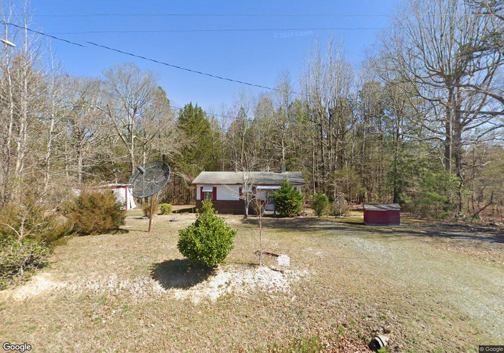
1036 Brower Rd Siler City, NC 27344
Estimated Value: $38,000 - $199,000
2
Beds
2
Baths
920
Sq Ft
$134/Sq Ft
Est. Value
About This Home
This home is located at 1036 Brower Rd, Siler City, NC 27344 and is currently estimated at $123,605, approximately $134 per square foot. 1036 Brower Rd is a home located in Chatham County with nearby schools including Siler City Elementary School, Chatham Middle, and Jordan Matthews High.
Ownership History
Date
Name
Owned For
Owner Type
Purchase Details
Closed on
Oct 9, 2025
Sold by
Sberro Odelia Emma and Naor Magnagi
Bought by
Anafi Yehonatan
Current Estimated Value
Purchase Details
Closed on
Aug 19, 2025
Sold by
Doster W Woods
Bought by
Sberro Odelia Emma
Purchase Details
Closed on
Dec 31, 1996
Bought by
Foxx Douglas and Foxx Thomas
Create a Home Valuation Report for This Property
The Home Valuation Report is an in-depth analysis detailing your home's value as well as a comparison with similar homes in the area
Home Values in the Area
Average Home Value in this Area
Purchase History
| Date | Buyer | Sale Price | Title Company |
|---|---|---|---|
| Anafi Yehonatan | -- | None Listed On Document | |
| Sberro Odelia Emma | $38,288 | None Listed On Document | |
| Foxx Douglas | -- | -- |
Source: Public Records
Tax History Compared to Growth
Tax History
| Year | Tax Paid | Tax Assessment Tax Assessment Total Assessment is a certain percentage of the fair market value that is determined by local assessors to be the total taxable value of land and additions on the property. | Land | Improvement |
|---|---|---|---|---|
| 2025 | $776 | $85,994 | $28,575 | $57,419 |
| 2024 | $776 | $63,740 | $26,193 | $37,547 |
| 2023 | $676 | $63,740 | $26,193 | $37,547 |
| 2022 | $625 | $63,740 | $26,193 | $37,547 |
| 2021 | $625 | $63,740 | $26,193 | $37,547 |
| 2020 | $666 | $68,537 | $23,184 | $45,353 |
| 2019 | $666 | $68,537 | $23,184 | $45,353 |
| 2018 | $617 | $68,537 | $23,184 | $45,353 |
| 2017 | $617 | $68,537 | $23,184 | $45,353 |
| 2016 | $568 | $61,203 | $20,700 | $40,503 |
| 2015 | $417 | $61,203 | $20,700 | $40,503 |
| 2014 | -- | $61,203 | $20,700 | $40,503 |
| 2013 | -- | $61,203 | $20,700 | $40,503 |
Source: Public Records
Map
Nearby Homes
- 2200 W 3rd St
- 2248 W 3rd St
- 3125 W 3rd St
- 1306 Sunset Dr
- 0 W 3rd St
- Tbd W 3rd St
- 44 Pine Hill Dr
- 1007 Driftwood Dr
- 128 Olde Manor Ct
- 11 Pine Forest Dr
- 707 Lakewood Dr
- 803 Woodland Dr
- 1011 Candlewood Cir
- 806 Cliftwood Dr
- 191 Pine Lake Dr
- 1004 Candlewood Cir
- 513 W Glendale St
- 519 W Raleigh St
- 254 Pine Forest Dr
- 1501 Duet Dr
- 1000 Brower Rd
- 721 Airport Rd
- 678 Airport Rd
- 678 Airport Rd
- 930 Brower Rd
- 662 Airport Rd
- 921 Brower Rd
- 599 Airport Rd
- 598 Airport Rd
- 565 Airport Rd
- 875 Brower Rd
- 852 Brower Rd
- 580 Airport Rd
- 570 Airport Rd
- 1960 Airport Rd Unit A
- 1960 Airport Rd
- 560 Airport Rd
- 534 Airport Rd
- 789 Ss Edwards Rd
- 521 Airport Rd