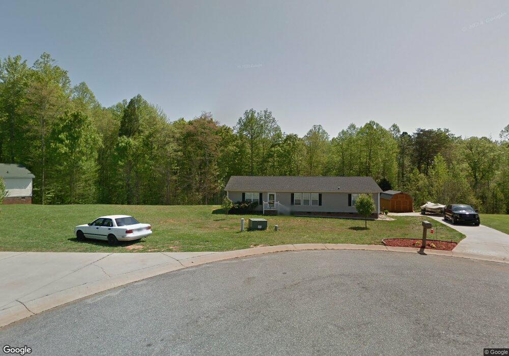
1036 Daniel Dr Stanley, NC 28164
Estimated Value: $259,000 - $292,000
3
Beds
2
Baths
1,736
Sq Ft
$158/Sq Ft
Est. Value
About This Home
This home is located at 1036 Daniel Dr, Stanley, NC 28164 and is currently estimated at $273,667, approximately $157 per square foot. 1036 Daniel Dr is a home located in Gaston County with nearby schools including Springfield Primary School, Kiser Elementary School, and Stanley Middle School.
Ownership History
Date
Name
Owned For
Owner Type
Purchase Details
Closed on
Apr 20, 2012
Sold by
Wallace Gary L and Wallace Carline N
Bought by
Graham Kenneth R
Current Estimated Value
Home Financials for this Owner
Home Financials are based on the most recent Mortgage that was taken out on this home.
Original Mortgage
$112,244
Outstanding Balance
$76,376
Interest Rate
3.9%
Mortgage Type
New Conventional
Estimated Equity
$197,291
Purchase Details
Closed on
Nov 1, 2011
Sold by
Dunlap Larry and Dunlap Tara Leann
Bought by
Wallace Gary L
Purchase Details
Closed on
Apr 30, 2007
Sold by
Royal Land Development Llc
Bought by
Dunlap Larry and Dunlap Tara Leann
Home Financials for this Owner
Home Financials are based on the most recent Mortgage that was taken out on this home.
Original Mortgage
$125,700
Interest Rate
6.1%
Mortgage Type
Purchase Money Mortgage
Purchase Details
Closed on
Nov 18, 2005
Sold by
Diamondback Properties Llc
Bought by
Royal Land Development Llc
Create a Home Valuation Report for This Property
The Home Valuation Report is an in-depth analysis detailing your home's value as well as a comparison with similar homes in the area
Home Values in the Area
Average Home Value in this Area
Purchase History
| Date | Buyer | Sale Price | Title Company |
|---|---|---|---|
| Graham Kenneth R | $110,000 | None Available | |
| Wallace Gary L | $61,201 | None Available | |
| Dunlap Larry | $166,500 | Stewart Title Guaranty Co | |
| Royal Land Development Llc | -- | -- |
Source: Public Records
Mortgage History
| Date | Status | Borrower | Loan Amount |
|---|---|---|---|
| Open | Graham Kenneth R | $112,244 | |
| Previous Owner | Dunlap Larry | $125,700 |
Source: Public Records
Tax History
| Year | Tax Paid | Tax Assessment Tax Assessment Total Assessment is a certain percentage of the fair market value that is determined by local assessors to be the total taxable value of land and additions on the property. | Land | Improvement |
|---|---|---|---|---|
| 2025 | $1,979 | $277,130 | $25,740 | $251,390 |
| 2024 | $1,979 | $277,130 | $25,740 | $251,390 |
| 2023 | $1,926 | $277,130 | $25,740 | $251,390 |
| 2022 | $1,547 | $168,200 | $15,500 | $152,700 |
| 2021 | $1,569 | $168,200 | $15,500 | $152,700 |
| 2019 | $1,569 | $168,200 | $15,500 | $152,700 |
| 2018 | $1,296 | $136,393 | $24,000 | $112,393 |
| 2017 | $1,298 | $136,393 | $24,000 | $112,393 |
| 2016 | $1,298 | $136,611 | $0 | $0 |
| 2014 | $1,449 | $154,149 | $30,000 | $124,149 |
Source: Public Records
Map
Nearby Homes
- 5005 Oconee Dr
- 5009 Oconee Dr
- 142 Shadowbrook Rd
- 111 Lake Rd
- 112 Lineberger St
- 2629 Dallas Stanley Hwy
- 116 Brooks Dr
- 105 Wingate Dr
- 102 Wingate Dr
- 616 Durham Rd
- 2102 Virginia Ellen Ct
- 120 General Pemberton St
- 710 Mcdowell Place
- 505 Coffeetree Ln
- 816 Joseph Antoon Cir
- 123 General Pemberton St
- 144 Walking Horse Run
- 138 Walking Horse Run
- 101 Citation Ln
- 211 General Stonewall Jackson St
- 1032 Daniel Dr
- 1037 Daniel Dr
- 1027 Daniel Dr
- 1028 Daniel Dr
- 1408 Ashley Creek Ct
- 1023 Daniel Dr
- 1024 Daniel Dr
- 1242 Blake Dr
- 1240 Blake Dr
- 1404 Ashley Creek Ct
- 237 Shadowbrook Dr
- 1412 Ashley Creek Ct
- 1019 Daniel Dr
- 239 Shadowbrook Rd
- 239 Shadowbrook Dr
- 1020 Daniel Dr
- 221 Shadowbrook Dr
- 1244 Blake Dr
- 1015 Daniel Dr
- 243 Shadowbrook Dr
Your Personal Tour Guide
Ask me questions while you tour the home.