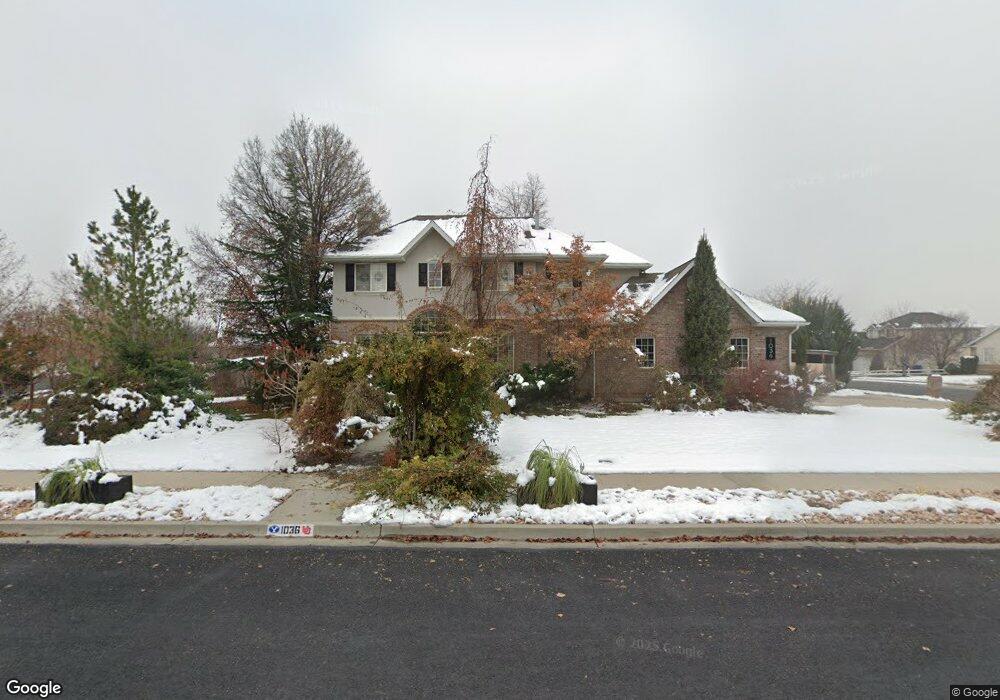
1036 E 1420 N American Fork, UT 84003
Estimated Value: $746,000 - $754,942
5
Beds
4
Baths
3,280
Sq Ft
$229/Sq Ft
Est. Value
About This Home
This home is located at 1036 E 1420 N, American Fork, UT 84003 and is currently estimated at $751,647, approximately $229 per square foot. 1036 E 1420 N is a home located in Utah County with nearby schools including Deerfield Elementary School, Mountain Ridge Junior High School, and American Fork High School.
Ownership History
Date
Name
Owned For
Owner Type
Purchase Details
Closed on
Jul 27, 2000
Sold by
Sneed Jacob A and Sneed Sue C
Bought by
Perry Douglas W and Perry Leslie A
Current Estimated Value
Home Financials for this Owner
Home Financials are based on the most recent Mortgage that was taken out on this home.
Original Mortgage
$163,000
Outstanding Balance
$56,555
Interest Rate
8.2%
Estimated Equity
$695,092
Purchase Details
Closed on
Nov 6, 1998
Sold by
Johnson Ray H and Johnson Edyn R
Bought by
Sneed Jacob A and Sneed Sue C
Purchase Details
Closed on
Oct 16, 1997
Sold by
Carlisle Robert J and Carlisle Diane E
Bought by
Johnson Ray H and Johnson Edyn R
Home Financials for this Owner
Home Financials are based on the most recent Mortgage that was taken out on this home.
Original Mortgage
$195,000
Interest Rate
7.49%
Mortgage Type
Construction
Create a Home Valuation Report for This Property
The Home Valuation Report is an in-depth analysis detailing your home's value as well as a comparison with similar homes in the area
Home Values in the Area
Average Home Value in this Area
Purchase History
| Date | Buyer | Sale Price | Title Company |
|---|---|---|---|
| Perry Douglas W | -- | Signature Title | |
| Sneed Jacob A | -- | Signature Title | |
| Johnson Ray H | -- | -- |
Source: Public Records
Mortgage History
| Date | Status | Borrower | Loan Amount |
|---|---|---|---|
| Open | Perry Douglas W | $163,000 | |
| Previous Owner | Johnson Ray H | $195,000 |
Source: Public Records
Tax History
| Year | Tax Paid | Tax Assessment Tax Assessment Total Assessment is a certain percentage of the fair market value that is determined by local assessors to be the total taxable value of land and additions on the property. | Land | Improvement |
|---|---|---|---|---|
| 2025 | $3,015 | $355,630 | -- | -- |
| 2024 | $3,015 | $334,950 | $0 | $0 |
| 2023 | $2,907 | $342,430 | $0 | $0 |
| 2022 | $2,854 | $331,760 | $0 | $0 |
| 2021 | $2,507 | $455,300 | $174,200 | $281,100 |
| 2020 | $2,436 | $429,000 | $161,300 | $267,700 |
| 2019 | $2,254 | $410,600 | $150,100 | $260,500 |
| 2018 | $2,149 | $374,300 | $142,600 | $231,700 |
| 2017 | $2,146 | $201,740 | $0 | $0 |
| 2016 | $1,964 | $171,545 | $0 | $0 |
| 2015 | $1,904 | $157,795 | $0 | $0 |
| 2014 | $1,746 | $142,725 | $0 | $0 |
Source: Public Records
Map
Nearby Homes
- 9587 N 4500 W
- 4675 W Ferguson Way
- 4552 W Windsor Cir
- 4531 W Cambridge Dr
- 9752 N Dorchester Dr
- 1125 N 1270 E
- 3518 N 1450 W
- 4979 W Willowbank Dr
- 1077 N 950 E
- 4968 W Evergreen Ln
- 1045 N 930 E Unit 58
- 5032 W Northwood Ln
- 5061 W Evergreen Ln
- 4814 W Washoe Ct
- 4956 W Gallatin Way
- 5034 W Green Ash Ln
- 5042 W Green Ash Ln
- 5056 W Green Ash Ln
- 4998 W Green Ash Ln
- 6552 N Bald Knoll
Your Personal Tour Guide
Ask me questions while you tour the home.