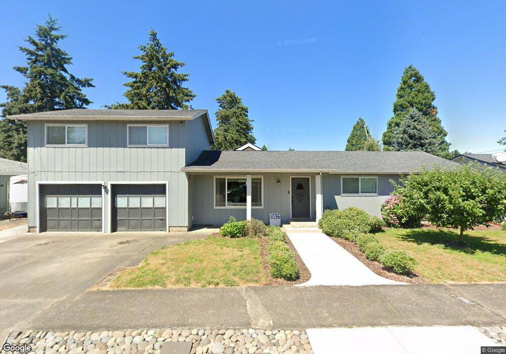
1036 Laurel Ave Springfield, OR 97478
East Springfield NeighborhoodEstimated Value: $403,000 - $476,000
3
Beds
2
Baths
1,742
Sq Ft
$256/Sq Ft
Est. Value
About This Home
This home is located at 1036 Laurel Ave, Springfield, OR 97478 and is currently estimated at $445,891, approximately $255 per square foot. 1036 Laurel Ave is a home located in Lane County with nearby schools including Douglas Gardens Elementary School, Agnes Stewart Middle School, and Springfield High School.
Ownership History
Date
Name
Owned For
Owner Type
Purchase Details
Closed on
Jul 7, 2011
Sold by
Schimonitz Yvonne A and Carter Yvonne A
Bought by
Nichols Mary Christine
Current Estimated Value
Home Financials for this Owner
Home Financials are based on the most recent Mortgage that was taken out on this home.
Original Mortgage
$169,750
Outstanding Balance
$124,673
Interest Rate
4.54%
Mortgage Type
Purchase Money Mortgage
Estimated Equity
$321,218
Purchase Details
Closed on
Feb 27, 2001
Sold by
Carter Edward J and Carter Yvonne A
Bought by
Carter Yvonne A
Create a Home Valuation Report for This Property
The Home Valuation Report is an in-depth analysis detailing your home's value as well as a comparison with similar homes in the area
Home Values in the Area
Average Home Value in this Area
Purchase History
| Date | Buyer | Sale Price | Title Company |
|---|---|---|---|
| Nichols Mary Christine | $175,000 | First American Title | |
| Carter Yvonne A | -- | -- |
Source: Public Records
Mortgage History
| Date | Status | Borrower | Loan Amount |
|---|---|---|---|
| Open | Nichols Mary Christine | $169,750 |
Source: Public Records
Tax History
| Year | Tax Paid | Tax Assessment Tax Assessment Total Assessment is a certain percentage of the fair market value that is determined by local assessors to be the total taxable value of land and additions on the property. | Land | Improvement |
|---|---|---|---|---|
| 2025 | $3,148 | $225,824 | -- | -- |
| 2024 | $3,063 | $219,247 | -- | -- |
| 2023 | $3,063 | $212,862 | $0 | $0 |
| 2022 | $2,913 | $206,663 | $0 | $0 |
| 2021 | $2,852 | $200,644 | $0 | $0 |
| 2020 | $2,769 | $194,800 | $0 | $0 |
| 2019 | $2,671 | $189,127 | $0 | $0 |
| 2018 | $2,586 | $178,271 | $0 | $0 |
| 2017 | $2,500 | $178,271 | $0 | $0 |
| 2016 | $2,436 | $173,079 | $0 | $0 |
| 2015 | $2,368 | $168,038 | $0 | $0 |
| 2014 | $2,301 | $163,144 | $0 | $0 |
Source: Public Records
Map
Nearby Homes
- 922 S 38th St
- 1091 Longridge Dr
- 3266 Mountain Creek Ln
- 0 Filbert Ln
- 3720 Virginia Ave
- 455 S 38th St
- 4131 Forsythia St
- 3503 Oregon Ave
- 875 S 43rd St
- 4324 Forsythia St
- 4452 Jessica Dr
- 154 37th St
- 557 S 44th St
- 4475 Daisy St Unit 87
- 4475 Daisy St
- 266 40th St
- 934 S 46th St
- 351 40th St
- 4667 Hailey Ct
- 463 35th St
- 1024 Laurel Ave
- 1048 Laurel Ave
- 1045 Dondea St
- 1027 Dondea St
- 1012 Laurel Ave
- 1060 Laurel Ave
- 1033 Dondea St
- 1011 Dondea St
- 1057 Dondea St
- 1035 Laurel Ave
- 1059 Laurel Ave
- 1071 Laurel Ave
- 1072 Laurel Ave
- 1004 Laurel Ave
- 1005 Dondea St
- 3715 Jasper Rd
- 1085 Laurel Ave
- 1069 Dondea St
- 3727 Jasper Rd
- 1088 Dondea St
Your Personal Tour Guide
Ask me questions while you tour the home.