Estimated Value: $826,375 - $876,000
4
Beds
3
Baths
1,840
Sq Ft
$462/Sq Ft
Est. Value
About This Home
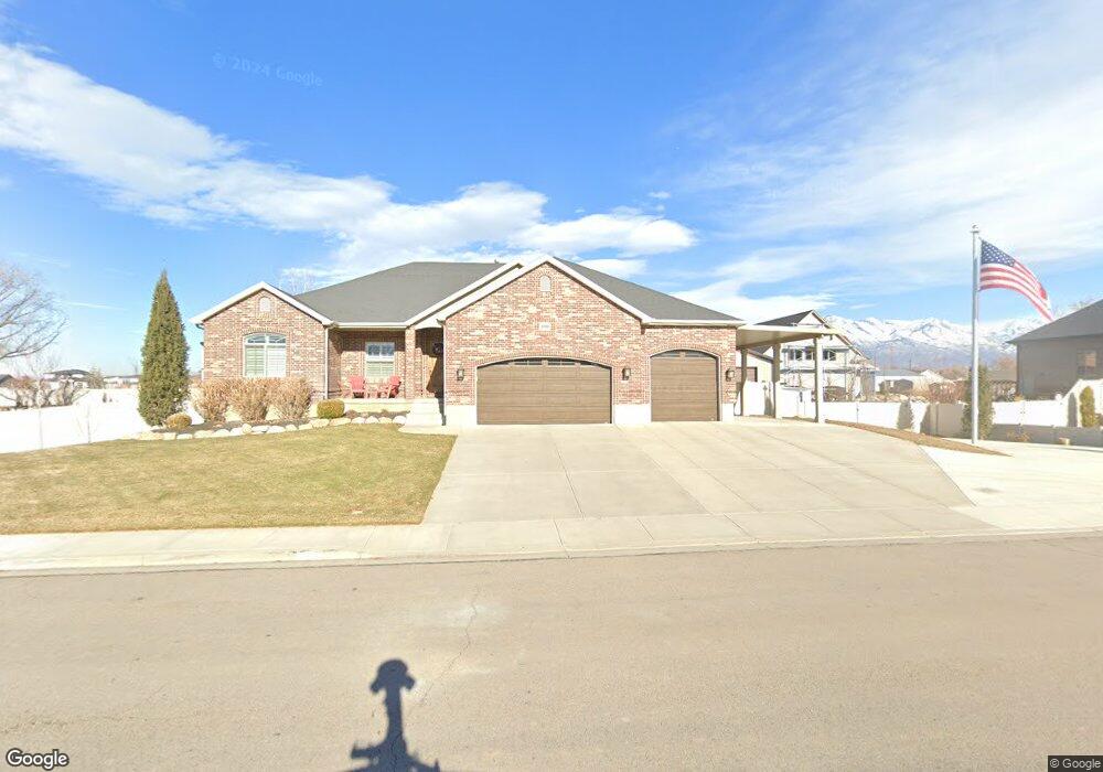
This home is located at 1036 W 550 N, Lehi, UT 84043 and is currently estimated at $850,094, approximately $462 per square foot. 1036 W 550 N is a home located in Utah County with nearby schools including Lehi Elementary School, Lehi Junior High School, and Lehi High School.
Ownership History
Date
Name
Owned For
Owner Type
Purchase Details
Closed on
Mar 31, 2021
Sold by
Brown Scott Robert
Bought by
Henrie Richard L and Henrie Janet
Current Estimated Value
Purchase Details
Closed on
Mar 30, 2021
Sold by
Brown Scott Robert
Bought by
Henrie Richard L and Henrie Janet
Purchase Details
Closed on
Jul 23, 2014
Sold by
Andrus Richard C and Andrus Sandra
Bought by
Henrie Richard L and Henrie Janet
Home Financials for this Owner
Home Financials are based on the most recent Mortgage that was taken out on this home.
Original Mortgage
$348,000
Interest Rate
4.16%
Mortgage Type
New Conventional
Purchase Details
Closed on
Mar 5, 2007
Sold by
Andrus Sandra
Bought by
Andrus Sandra and Andrus Richard C
Home Financials for this Owner
Home Financials are based on the most recent Mortgage that was taken out on this home.
Original Mortgage
$151,000
Interest Rate
6.23%
Mortgage Type
Construction
Create a Home Valuation Report for This Property
The Home Valuation Report is an in-depth analysis detailing your home's value as well as a comparison with similar homes in the area
Home Values in the Area
Average Home Value in this Area
Purchase History
| Date | Buyer | Sale Price | Title Company |
|---|---|---|---|
| Henrie Richard L | -- | Provo Land Title | |
| Henrie Richard L | -- | Provo Land Title Company | |
| Henrie Richard L | -- | Select Title Ins Agency | |
| Andrus Sandra | -- | Executive Title | |
| Andrus Sandra | -- | Executive Title |
Source: Public Records
Mortgage History
| Date | Status | Borrower | Loan Amount |
|---|---|---|---|
| Previous Owner | Henrie Richard L | $348,000 | |
| Previous Owner | Andrus Sandra | $151,000 |
Source: Public Records
Tax History Compared to Growth
Tax History
| Year | Tax Paid | Tax Assessment Tax Assessment Total Assessment is a certain percentage of the fair market value that is determined by local assessors to be the total taxable value of land and additions on the property. | Land | Improvement |
|---|---|---|---|---|
| 2025 | $3,376 | $446,380 | $330,600 | $481,000 |
| 2024 | $3,376 | $395,120 | $0 | $0 |
| 2023 | $3,096 | $393,360 | $0 | $0 |
| 2022 | $3,492 | $430,210 | $0 | $0 |
| 2021 | $3,111 | $579,300 | $191,300 | $388,000 |
| 2020 | $2,932 | $539,700 | $177,100 | $362,600 |
| 2019 | $2,608 | $499,100 | $177,100 | $322,000 |
| 2018 | $2,433 | $440,200 | $151,800 | $288,400 |
| 2017 | $2,442 | $234,850 | $0 | $0 |
| 2016 | $2,424 | $216,315 | $0 | $0 |
| 2015 | $2,443 | $206,965 | $0 | $0 |
| 2014 | $2,268 | $190,960 | $0 | $0 |
Source: Public Records
Map
Nearby Homes