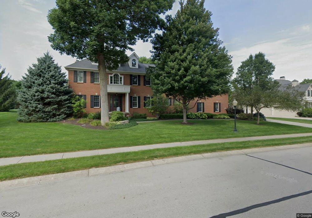
10360 Charter Oaks Carmel, IN 46032
West Carmel NeighborhoodEstimated Value: $1,567,000 - $1,859,427
5
Beds
7
Baths
9,386
Sq Ft
$187/Sq Ft
Est. Value
About This Home
This home is located at 10360 Charter Oaks, Carmel, IN 46032 and is currently estimated at $1,755,357, approximately $187 per square foot. 10360 Charter Oaks is a home located in Hamilton County with nearby schools including Towne Meadow Elementary School, Creekside Middle School, and Carmel High School.
Ownership History
Date
Name
Owned For
Owner Type
Purchase Details
Closed on
Oct 12, 2009
Sold by
Todd Eric D and Todd Talicia L
Bought by
Edmundson Chad and Edmundson Lauren
Current Estimated Value
Purchase Details
Closed on
Dec 11, 2003
Sold by
Steven A Wilson Inc
Bought by
Todd Eric D and Todd Talicia L
Home Financials for this Owner
Home Financials are based on the most recent Mortgage that was taken out on this home.
Original Mortgage
$500,000
Interest Rate
4.87%
Mortgage Type
Unknown
Create a Home Valuation Report for This Property
The Home Valuation Report is an in-depth analysis detailing your home's value as well as a comparison with similar homes in the area
Home Values in the Area
Average Home Value in this Area
Purchase History
| Date | Buyer | Sale Price | Title Company |
|---|---|---|---|
| Edmundson Chad | -- | Chicago Title Insurance Co | |
| Todd Eric D | -- | -- |
Source: Public Records
Mortgage History
| Date | Status | Borrower | Loan Amount |
|---|---|---|---|
| Previous Owner | Todd Eric D | $500,000 |
Source: Public Records
Tax History
| Year | Tax Paid | Tax Assessment Tax Assessment Total Assessment is a certain percentage of the fair market value that is determined by local assessors to be the total taxable value of land and additions on the property. | Land | Improvement |
|---|---|---|---|---|
| 2025 | $19,519 | $1,878,200 | $328,100 | $1,550,100 |
| 2024 | $14,783 | $1,682,000 | $328,100 | $1,353,900 |
| 2023 | $14,848 | $1,286,300 | $328,100 | $958,200 |
| 2022 | $14,867 | $1,279,600 | $154,700 | $1,124,900 |
| 2021 | $12,018 | $1,041,300 | $154,700 | $886,600 |
| 2020 | $12,037 | $1,043,000 | $154,700 | $888,300 |
| 2019 | $11,198 | $971,200 | $187,700 | $783,500 |
| 2018 | $11,370 | $1,005,600 | $187,700 | $817,900 |
| 2017 | $11,618 | $1,002,500 | $187,700 | $814,800 |
| 2016 | $11,345 | $1,021,000 | $187,700 | $833,300 |
| 2014 | $11,398 | $1,031,500 | $187,700 | $843,800 |
Source: Public Records
Map
Nearby Homes
- 9889 Summerlakes Dr
- 1841 Asherwood Ln
- 1611 Asherwood Ln
- 1616 Asherwood Ln
- 9699 Prairiewood Way
- 1470 Asherwood Ln
- 1743 Asherwood Ln
- 1434 N Asherwood Ln
- 2304 Brightwell Place
- 10837 Thunderbird Dr
- 2211 Colfax Ln
- 2358 Colfax Ln
- 1733 Cloister Dr
- 2380 Colfax Ln
- 9696 Ditch Rd
- 2482 Chaseway Ct
- 10924 Thunderbird Dr
- 9364 Oak Run East Dr
- 2502 Chaseway Ct
- 9540 Drakeford Dr
- 10382 Charter Oaks
- 10348 High Grove
- 10348 High Grove Dr
- 10323 High Grove Dr
- 10323 High Grove
- 10381 High Grove
- 10331 High Grove Dr
- 10369 Charter Oaks
- 10331 High Grove
- 10332 Windemere
- 10396 Charter Oaks
- 10393 High Grove Dr
- 10393 High Grove
- 10345 High Grove
- 10327 Windemere
- 10387 Charter Oaks
- 10345 High Grove Dr
- 10401 High Grove
- 10401 High Grove Dr
- 10356 High Grove
Your Personal Tour Guide
Ask me questions while you tour the home.