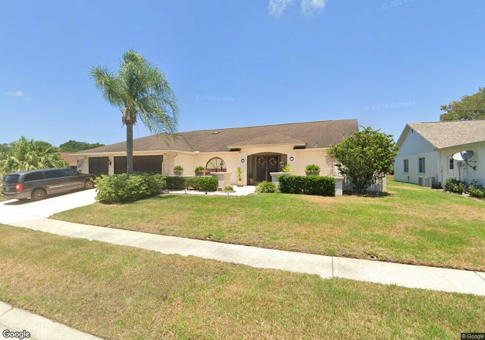
10363 Flag Rd Spring Hill, FL 34608
Estimated Value: $372,934 - $452,000
4
Beds
2
Baths
2,237
Sq Ft
$184/Sq Ft
Est. Value
About This Home
This home is located at 10363 Flag Rd, Spring Hill, FL 34608 and is currently estimated at $411,234, approximately $183 per square foot. 10363 Flag Rd is a home located in Hernando County with nearby schools including Suncoast Elementary School, Powell Middle School, and Frank W. Springstead High School.
Ownership History
Date
Name
Owned For
Owner Type
Purchase Details
Closed on
Oct 8, 2003
Sold by
Matthews Samuel P
Bought by
Houle Raymond and Morrison Pauline
Current Estimated Value
Home Financials for this Owner
Home Financials are based on the most recent Mortgage that was taken out on this home.
Original Mortgage
$50,000
Outstanding Balance
$22,947
Interest Rate
6.32%
Estimated Equity
$388,287
Purchase Details
Closed on
Apr 18, 2002
Sold by
Harrison Claire I
Bought by
Matthews Samuel P
Home Financials for this Owner
Home Financials are based on the most recent Mortgage that was taken out on this home.
Original Mortgage
$127,920
Interest Rate
7.07%
Mortgage Type
Purchase Money Mortgage
Create a Home Valuation Report for This Property
The Home Valuation Report is an in-depth analysis detailing your home's value as well as a comparison with similar homes in the area
Home Values in the Area
Average Home Value in this Area
Purchase History
| Date | Buyer | Sale Price | Title Company |
|---|---|---|---|
| Houle Raymond | $179,000 | -- | |
| Matthews Samuel P | $159,900 | -- |
Source: Public Records
Mortgage History
| Date | Status | Borrower | Loan Amount |
|---|---|---|---|
| Open | Houle Raymond | $50,000 | |
| Previous Owner | Matthews Samuel P | $127,920 |
Source: Public Records
Tax History
| Year | Tax Paid | Tax Assessment Tax Assessment Total Assessment is a certain percentage of the fair market value that is determined by local assessors to be the total taxable value of land and additions on the property. | Land | Improvement |
|---|---|---|---|---|
| 2025 | $2,443 | $159,453 | -- | -- |
| 2024 | $2,347 | $154,959 | -- | -- |
| 2023 | $2,347 | $150,446 | $0 | $0 |
| 2022 | $2,255 | $146,064 | $0 | $0 |
| 2021 | $2,252 | $141,810 | $0 | $0 |
| 2020 | $2,106 | $139,852 | $0 | $0 |
| 2019 | $2,104 | $136,708 | $0 | $0 |
| 2018 | $1,452 | $134,159 | $0 | $0 |
| 2017 | $1,772 | $131,400 | $0 | $0 |
| 2016 | $1,715 | $128,697 | $0 | $0 |
| 2015 | $1,727 | $127,802 | $0 | $0 |
| 2014 | $1,688 | $126,788 | $0 | $0 |
Source: Public Records
Map
Nearby Homes
- 10351 Flag Rd
- 1039 Greenturf Rd
- 1113 El Portico Ln
- 10443 Casa Grande Cir
- 10428 Casa Grande Cir
- 10421 Templewood Ct
- 10400 Casa Grande Cir
- 11018 Audie Brook Dr
- 10344 Henderson St
- 11008 Casa Grande Cir
- 10464 Henderson St
- 1285 Henry Ave
- 1150 Bentley Ave
- 10340 Ventura Dr
- 1215 Gatewood Ave
- 1139 Bentley Ave
- 1542 Overland Dr
- 10348 Ventura Dr
- 10243 Locker Dr
- 11053 Via Santiago Ct
- 10371 Flag Rd
- 10396 Sandtrap Dr
- 10377 Flag Rd
- 10341 Flag Rd
- 10404 Sandtrap Dr
- 1109 Hook Dr
- 10388 Sandtrap Dr
- 1110 Hook Dr
- 1088 Tournament Dr
- 10381 Flag Rd
- 10412 Sandtrap Dr
- 1102 Hook Dr
- 1103 Hook Dr
- 1072 Tournament Dr
- 10395 Sandtrap Dr
- 10420 Sandtrap Dr
- 1041 Greenturf Rd
- 10391 Flag Rd
- 10403 Sandtrap Dr
- 10389 Sandtrap Dr
Your Personal Tour Guide
Ask me questions while you tour the home.