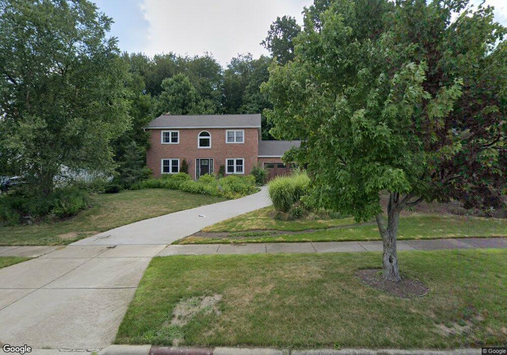
10363 Hanford Ln Twinsburg, OH 44087
Estimated Value: $365,000 - $433,000
3
Beds
3
Baths
1,920
Sq Ft
$206/Sq Ft
Est. Value
About This Home
This home is located at 10363 Hanford Ln, Twinsburg, OH 44087 and is currently estimated at $396,295, approximately $206 per square foot. 10363 Hanford Ln is a home located in Summit County with nearby schools including Wilcox Primary School, Samuel Bissell Elementary School, and Dodge Intermediate School.
Ownership History
Date
Name
Owned For
Owner Type
Purchase Details
Closed on
May 22, 1996
Sold by
Kretschmer Hans J
Bought by
Hinte Christropher P and Hinte Suzanne
Current Estimated Value
Home Financials for this Owner
Home Financials are based on the most recent Mortgage that was taken out on this home.
Original Mortgage
$175,500
Outstanding Balance
$10,091
Interest Rate
8.1%
Mortgage Type
New Conventional
Estimated Equity
$386,204
Create a Home Valuation Report for This Property
The Home Valuation Report is an in-depth analysis detailing your home's value as well as a comparison with similar homes in the area
Home Values in the Area
Average Home Value in this Area
Purchase History
| Date | Buyer | Sale Price | Title Company |
|---|---|---|---|
| Hinte Christropher P | $185,000 | -- |
Source: Public Records
Mortgage History
| Date | Status | Borrower | Loan Amount |
|---|---|---|---|
| Open | Hinte Christropher P | $175,500 |
Source: Public Records
Tax History Compared to Growth
Tax History
| Year | Tax Paid | Tax Assessment Tax Assessment Total Assessment is a certain percentage of the fair market value that is determined by local assessors to be the total taxable value of land and additions on the property. | Land | Improvement |
|---|---|---|---|---|
| 2025 | $5,126 | $106,512 | $24,164 | $82,348 |
| 2024 | $5,126 | $106,512 | $24,164 | $82,348 |
| 2023 | $5,126 | $106,512 | $24,164 | $82,348 |
| 2022 | $4,460 | $82,670 | $18,732 | $63,938 |
| 2021 | $4,481 | $82,670 | $18,732 | $63,938 |
| 2020 | $4,347 | $82,670 | $18,730 | $63,940 |
| 2019 | $4,372 | $77,720 | $18,730 | $58,990 |
| 2018 | $4,285 | $77,720 | $18,730 | $58,990 |
| 2017 | $3,667 | $77,720 | $18,730 | $58,990 |
| 2016 | $3,645 | $70,510 | $18,730 | $51,780 |
| 2015 | $3,667 | $70,510 | $18,730 | $51,780 |
| 2014 | $3,660 | $70,510 | $18,730 | $51,780 |
| 2013 | $3,719 | $71,720 | $18,730 | $52,990 |
Source: Public Records
Map
Nearby Homes
- 10393 N Pond Ln
- 10502 White Ash Trail
- 10375 W Cobblestone Ln Unit 2
- 34105 Blue Heron Dr
- 10424 Oviatt Ln
- 10085 Glen Eagle Ln Unit 35AG
- 10240 Orchard Hill Ln Unit I23
- 10169 Timothy Ln
- 7471 Som Center Rd
- 3123 Killingworth Ln
- 9933 Cynthia Dr
- 7460 Hillside Ln
- 2923 Alling Dr
- 12162 Waywood Dr
- 10219 Wagner Ct
- 2668 Walton Blvd
- 10132 Scenic View Dr
- 10358 Townley Ct
- 32700 Pettibone Rd
- 2627 Post Rd
- 10373 Hanford Ln
- 10353 Hanford Ln
- 10381 Hanford Ln
- 10345 Hanford Ln
- 10366 White Ash Trail
- 10368 White Ash Trail
- 10356 White Ash Trail
- 10350 Hanford Ln
- 10389 Hanford Ln
- 10378 Hanford Ln
- 10354 White Ash Trail
- 10370 White Ash Trail
- 10352 White Ash Trail
- 10384 Hanford Ln
- 10344 Hanford Ln
- 10359 White Ash Trail
- 10359 White Ash Trail Unit 3A
- 10382 White Ash Trail Unit AA54
- 10382 White Ash Trail Unit 54aa
- 10397 Hanford Ln