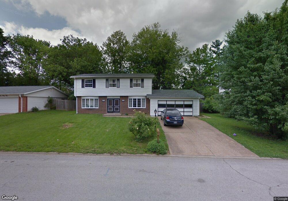
1037 Five Forks Dr Belleville, IL 62221
Estimated Value: $169,000 - $210,774
4
Beds
3
Baths
2,330
Sq Ft
$82/Sq Ft
Est. Value
About This Home
This home is located at 1037 Five Forks Dr, Belleville, IL 62221 and is currently estimated at $191,444, approximately $82 per square foot. 1037 Five Forks Dr is a home located in St. Clair County with nearby schools including Belle Valley Elementary School-North, Zion Lutheran School Belleville, and St Teresa Catholic School.
Ownership History
Date
Name
Owned For
Owner Type
Purchase Details
Closed on
Dec 21, 2011
Sold by
Kuester Arlen O
Bought by
Jones Jason B
Current Estimated Value
Home Financials for this Owner
Home Financials are based on the most recent Mortgage that was taken out on this home.
Original Mortgage
$74,022
Outstanding Balance
$50,636
Interest Rate
4.01%
Mortgage Type
FHA
Estimated Equity
$140,808
Purchase Details
Closed on
Jan 9, 2008
Sold by
Kuester Arlen O
Bought by
Kuester Arlen O and Arlen O Kuester Revocable Trust
Create a Home Valuation Report for This Property
The Home Valuation Report is an in-depth analysis detailing your home's value as well as a comparison with similar homes in the area
Home Values in the Area
Average Home Value in this Area
Purchase History
| Date | Buyer | Sale Price | Title Company |
|---|---|---|---|
| Jones Jason B | $82,000 | Town & Country Title Co | |
| Kuester Arlen O | -- | Pti |
Source: Public Records
Mortgage History
| Date | Status | Borrower | Loan Amount |
|---|---|---|---|
| Open | Jones Jason B | $74,022 |
Source: Public Records
Tax History
| Year | Tax Paid | Tax Assessment Tax Assessment Total Assessment is a certain percentage of the fair market value that is determined by local assessors to be the total taxable value of land and additions on the property. | Land | Improvement |
|---|---|---|---|---|
| 2024 | $3,748 | $50,340 | $6,589 | $43,751 |
| 2023 | $3,942 | $51,527 | $6,498 | $45,029 |
| 2022 | $3,705 | $46,928 | $5,918 | $41,010 |
| 2021 | $3,643 | $45,002 | $5,675 | $39,327 |
| 2020 | $3,552 | $41,910 | $5,285 | $36,625 |
| 2019 | $3,406 | $41,201 | $5,394 | $35,807 |
| 2018 | $3,277 | $40,149 | $5,256 | $34,893 |
| 2017 | $3,188 | $39,080 | $5,116 | $33,964 |
| 2016 | $3,185 | $37,733 | $4,940 | $32,793 |
| 2014 | $1,875 | $26,842 | $6,341 | $20,501 |
| 2013 | $4,083 | $26,842 | $6,341 | $20,501 |
Source: Public Records
Map
Nearby Homes
- 421 Stone River Rd
- 405 Todd Ln
- 1301 Springfield Dr
- 1419 Vicksburg Dr
- 1423 Vicksburg Dr
- 3213 West Blvd
- 1319 Springfield Dr
- 204 Bunker Hill Rd
- 1509 Potomac Dr
- 3313 Denvershire Dr
- 3306 Saratoga Dr Unit 3304/3306
- 2077 Camrose Green St
- 3300 Berwin Green Dr
- 2073 Camrose Green St
- 2069 Camrose Green St
- 2065 Camrose Green St
- 3304 Berwin Green Dr
- 2061 Camrose Green St
- 2057 Camrose Green St
- 2053 Camrose Green St
- 1033 Five Forks Dr
- 1101 Five Forks Dr
- 1105 Five Forks Dr
- 1029 Five Forks Dr
- 1036 Five Forks Dr
- 1100 Five Forks Dr
- 1032 Five Forks Dr
- 1028 Five Forks Dr
- 1025 5 Forks Dr
- 1032 Brookshire Ct
- 1109 Five Forks Dr
- 1025 Five Forks Dr
- 309 Mossy Creek Dr
- 1048 Brookshire Ct
- 1024 Brookshire Ct
- 1037 Rutledge Dr
- 1024 Five Forks Dr
- 1033 Rutledge Dr
- 1101 Rutledge Dr
Your Personal Tour Guide
Ask me questions while you tour the home.