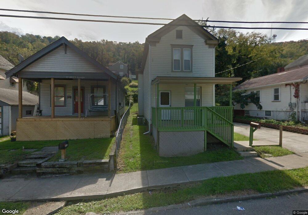
1037 Howard St Bridgeport, OH 43912
Estimated Value: $53,000 - $78,000
1
Bed
1
Bath
811
Sq Ft
$78/Sq Ft
Est. Value
About This Home
This home is located at 1037 Howard St, Bridgeport, OH 43912 and is currently estimated at $63,419, approximately $78 per square foot. 1037 Howard St is a home located in Belmont County with nearby schools including Bridgeport Elementary School, Bridgeport Middle School, and Bridgeport High School.
Ownership History
Date
Name
Owned For
Owner Type
Purchase Details
Closed on
Feb 19, 2010
Sold by
Carman James B
Bought by
Shrieve Samuel J
Current Estimated Value
Purchase Details
Closed on
Feb 16, 1999
Sold by
Carman James
Bought by
Carman James
Purchase Details
Closed on
Jan 3, 1997
Sold by
Vance L S
Bought by
Vance L S
Purchase Details
Closed on
Jun 6, 1994
Sold by
Kern Andrew S
Bought by
Kern Andrew S
Purchase Details
Closed on
Jan 1, 1986
Sold by
Berry Romaine
Bought by
Berry Romaine
Create a Home Valuation Report for This Property
The Home Valuation Report is an in-depth analysis detailing your home's value as well as a comparison with similar homes in the area
Home Values in the Area
Average Home Value in this Area
Purchase History
| Date | Buyer | Sale Price | Title Company |
|---|---|---|---|
| Shrieve Samuel J | $15,000 | None Available | |
| Carman James | $18,000 | -- | |
| Vance L S | $18,000 | -- | |
| Kern Andrew S | $14,500 | -- | |
| Berry Romaine | -- | -- |
Source: Public Records
Tax History Compared to Growth
Tax History
| Year | Tax Paid | Tax Assessment Tax Assessment Total Assessment is a certain percentage of the fair market value that is determined by local assessors to be the total taxable value of land and additions on the property. | Land | Improvement |
|---|---|---|---|---|
| 2024 | $634 | $18,910 | $1,330 | $17,580 |
| 2023 | $617 | $13,570 | $1,340 | $12,230 |
| 2022 | $473 | $13,566 | $1,337 | $12,229 |
| 2021 | $1,239 | $13,566 | $1,337 | $12,229 |
| 2020 | $259 | $11,300 | $1,110 | $10,190 |
| 2019 | $920 | $11,300 | $1,110 | $10,190 |
| 2018 | $115 | $11,300 | $1,110 | $10,190 |
| 2017 | $5 | $7,690 | $1,310 | $6,380 |
| 2016 | $602 | $7,690 | $1,310 | $6,380 |
| 2015 | $672 | $7,690 | $1,310 | $6,380 |
| 2014 | $14 | $8,690 | $1,190 | $7,500 |
| 2013 | -- | $8,690 | $1,190 | $7,500 |
Source: Public Records
Map
Nearby Homes
- 1049 Buckeye St
- 866 Main St
- 20 Locust Ave
- 902 National Rd
- 67478 Kirkwood Heights Rd
- 8 Spring St
- 16 Patterson Rd
- 56624 Boyd Ave
- 56316 National Rd
- 56559 Boyd Ave
- 67605 Kirkwood Heights Rd
- 67620 Kirkwood Heights Rd
- 67730 Kirkwood Heights Rd
- 61 Laipple St
- 0 Ohio 7
- 116 Ohio St
- 219 S York St
- 217 N Huron St
- 50 Kentucky St
- 301 N Huron St
- 1037 Howard St
- 1033 Howard St
- 1043 Howard St
- 1045 Howard St
- 1030 Minellen Dr
- 1040 Minellen Dr
- 1029 Howard St
- 1047 Howard St
- 1036 Howard St
- 1020 Minellen Dr
- 1034 Howard St
- 1049 Howard St
- 1027 Howard St
- 1027 Howard St
- 1044 Minellen Dr
- 1042 Howard St
- 1028B Howard St
- 1023 Howard St
- 1046 Howard St
- 1018 Minellen Dr