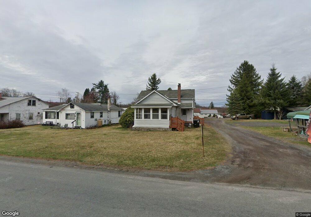
1037 Route 390 Greentown, PA 18426
Estimated Value: $191,000 - $197,918
3
Beds
1
Bath
1,062
Sq Ft
$183/Sq Ft
Est. Value
About This Home
This home is located at 1037 Route 390, Greentown, PA 18426 and is currently estimated at $194,459, approximately $183 per square foot. 1037 Route 390 is a home with nearby schools including Wallenpaupack Area High School.
Ownership History
Date
Name
Owned For
Owner Type
Purchase Details
Closed on
Sep 21, 2023
Sold by
Haser Edward W
Bought by
Prell David R and Prell Kelly A
Current Estimated Value
Home Financials for this Owner
Home Financials are based on the most recent Mortgage that was taken out on this home.
Original Mortgage
$171,000
Outstanding Balance
$167,527
Interest Rate
7.19%
Estimated Equity
$26,932
Purchase Details
Closed on
Aug 29, 2023
Sold by
Haser Paul H
Bought by
Haser Edward W and Umstead Walter H
Home Financials for this Owner
Home Financials are based on the most recent Mortgage that was taken out on this home.
Original Mortgage
$171,000
Outstanding Balance
$167,527
Interest Rate
7.19%
Estimated Equity
$26,932
Create a Home Valuation Report for This Property
The Home Valuation Report is an in-depth analysis detailing your home's value as well as a comparison with similar homes in the area
Home Values in the Area
Average Home Value in this Area
Purchase History
| Date | Buyer | Sale Price | Title Company |
|---|---|---|---|
| Prell David R | $180,000 | -- | |
| Haser Edward W | -- | -- |
Source: Public Records
Mortgage History
| Date | Status | Borrower | Loan Amount |
|---|---|---|---|
| Open | Prell David R | $171,000 |
Source: Public Records
Tax History Compared to Growth
Tax History
| Year | Tax Paid | Tax Assessment Tax Assessment Total Assessment is a certain percentage of the fair market value that is determined by local assessors to be the total taxable value of land and additions on the property. | Land | Improvement |
|---|---|---|---|---|
| 2025 | $1,208 | $10,810 | $1,250 | $9,560 |
| 2024 | $1,208 | $10,810 | $1,250 | $9,560 |
| 2023 | $1,157 | $10,810 | $1,250 | $9,560 |
| 2022 | $1,130 | $10,810 | $1,250 | $9,560 |
| 2021 | $1,114 | $10,810 | $1,250 | $9,560 |
| 2020 | $1,114 | $10,810 | $1,250 | $9,560 |
| 2019 | $1,078 | $10,810 | $1,250 | $9,560 |
| 2018 | $1,060 | $10,810 | $1,250 | $9,560 |
| 2017 | $1,027 | $10,810 | $1,250 | $9,560 |
| 2016 | $0 | $10,810 | $1,250 | $9,560 |
| 2014 | -- | $10,810 | $1,250 | $9,560 |
Source: Public Records
Map
Nearby Homes
- 1015 Pennsylvania 390
- 1015 Route 390
- 58 Branch Rd
- 120 Melody Ln
- 926 Pennsylvania 390
- 153 Stone Chair Trail
- 108 Hughes Dr
- 116 S Sunset Dr
- Lot 258 Bear Trap Mountain Rd
- 142 E Balsam Rd
- 111 Meadow Ln
- lot 118 Route 390 & Oak Rd
- Lot 1301 Lakeside Dr
- Lot 1302 Lakeside Dr
- SkyView Lake Redwood Dr
- 1708 Horizon Dr
- SkyView Lakes Oakwood Dr
- SkyView Lake Oakwood Dr
- SkyView Lakes Oak Wood Dr
- 0 Horizon Dr
- 1039 Pennsylvania 390
- 157 Pennsylvania 390
- 1041 Route 390
- 110 Circle Ln
- 107 Circle Ln
- 29 Wilson Ln
- 1031 Route 390
- 100 Our Place Dr
- 111 Pennsylvania 390
- 109 Circle Ln
- 1030 Pennsylvania 390
- 39 Wilson Ln
- 113 Circle Ln
- 116 Circle Ln
- 47 Wilson Ln
- 115 Circle Ln
- 122 Circle Ln
- 1045 Route 390
- 36 Wilson Ln
- 57 Wilson Ln