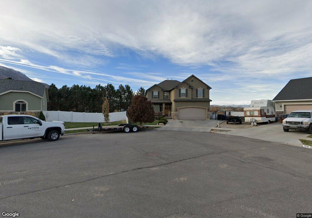
1037 W 1620 S Payson, UT 84651
Estimated Value: $616,000 - $819,000
5
Beds
3
Baths
3,696
Sq Ft
$182/Sq Ft
Est. Value
About This Home
This home is located at 1037 W 1620 S, Payson, UT 84651 and is currently estimated at $671,031, approximately $181 per square foot. 1037 W 1620 S is a home located in Utah County with nearby schools including Spring Lake Elementary, Payson Junior High School, and Payson High School.
Ownership History
Date
Name
Owned For
Owner Type
Purchase Details
Closed on
Nov 17, 2021
Sold by
Wells William Jeffery
Bought by
Wells William Jeffery and Wells Erin Kathleen
Current Estimated Value
Home Financials for this Owner
Home Financials are based on the most recent Mortgage that was taken out on this home.
Original Mortgage
$356,000
Outstanding Balance
$326,213
Interest Rate
2.99%
Mortgage Type
New Conventional
Estimated Equity
$344,818
Purchase Details
Closed on
Apr 29, 2016
Sold by
Steve W Larsen
Bought by
Wells Wiliam
Home Financials for this Owner
Home Financials are based on the most recent Mortgage that was taken out on this home.
Original Mortgage
$228,950
Interest Rate
3.66%
Purchase Details
Closed on
Jan 2, 2008
Sold by
Kriser Developments Inc
Bought by
Larsen Steve W and Larsen Jennie C
Home Financials for this Owner
Home Financials are based on the most recent Mortgage that was taken out on this home.
Original Mortgage
$281,000
Interest Rate
6.15%
Mortgage Type
Construction
Create a Home Valuation Report for This Property
The Home Valuation Report is an in-depth analysis detailing your home's value as well as a comparison with similar homes in the area
Home Values in the Area
Average Home Value in this Area
Purchase History
| Date | Buyer | Sale Price | Title Company |
|---|---|---|---|
| Wells William Jeffery | -- | New Title Company Name | |
| Wells Wiliam | -- | -- | |
| Larsen Steve W | -- | Mountain West Title Company |
Source: Public Records
Mortgage History
| Date | Status | Borrower | Loan Amount |
|---|---|---|---|
| Open | Wells William Jeffery | $356,000 | |
| Previous Owner | Wells Wiliam | $228,950 | |
| Previous Owner | Wells Wiliam | -- | |
| Previous Owner | Larsen Steve W | $281,000 |
Source: Public Records
Tax History Compared to Growth
Tax History
| Year | Tax Paid | Tax Assessment Tax Assessment Total Assessment is a certain percentage of the fair market value that is determined by local assessors to be the total taxable value of land and additions on the property. | Land | Improvement |
|---|---|---|---|---|
| 2025 | $2,831 | $299,255 | $184,200 | $359,900 |
| 2024 | $2,831 | $288,090 | $0 | $0 |
| 2023 | $2,927 | $298,705 | $0 | $0 |
| 2022 | $3,095 | $310,640 | $0 | $0 |
| 2021 | $2,626 | $422,800 | $120,900 | $301,900 |
| 2020 | $2,493 | $392,600 | $109,900 | $282,700 |
| 2019 | $2,314 | $373,700 | $91,000 | $282,700 |
| 2018 | $2,328 | $362,300 | $79,600 | $282,700 |
| 2017 | $2,088 | $174,790 | $0 | $0 |
| 2016 | $1,956 | $162,635 | $0 | $0 |
| 2015 | $1,919 | $158,510 | $0 | $0 |
| 2014 | $1,880 | $156,420 | $0 | $0 |
Source: Public Records
Map
Nearby Homes
- 1733 S 1100 W Unit 12
- 1605 S 1100 W
- 1763 S 1100 W Unit 14
- 1597 S 1100 W
- 922 W 1620 S
- 1579 S 910 W
- 1592 S 790 W
- 1582 S 790 W
- 1002 W Temple Rim Ln
- 4125 W 12000 S
- 802 Brookside Ct
- 1338 S 1150 W
- 598 W Saddlebrook Dr
- 588 W 1450 S
- 1287 S 1080 W
- 480 W 1890 S
- 1216 S 1150 W Unit 19
- 1856 S 410 W
- 1868 S 410 W
- 1825 S 410 W
- 1618 S 1030 W
- 1027 W 1620 S
- 1685 S 1100 W Unit 10
- 1651 S 1100 W
- 1651 S 1100 W Unit 9
- 1717 S 1100 W
- 1612 S 1030 W
- 1007 W 1620 S
- 1613 S 1100 W Unit 8
- 1613 S 1100 W
- 1018 W 1620 S
- 1733 S 1100 W
- 1797 S 1100 W
- 1797 S 1100 W Unit 16
- 1606 S 1030 W
- 998 W 1620 S
- 1741 S 1100 W
- 979 W 1620 S
- 984 W 1620 S
- 1003 W 1600 S