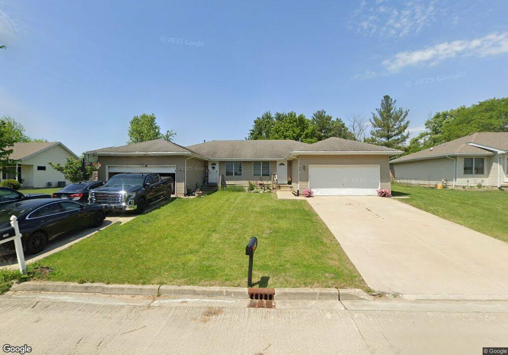
1038 Carter St Marseilles, IL 61341
Estimated Value: $205,629 - $405,000
3
Beds
2
Baths
1,500
Sq Ft
$182/Sq Ft
Est. Value
About This Home
This home is located at 1038 Carter St, Marseilles, IL 61341 and is currently estimated at $273,157, approximately $182 per square foot. 1038 Carter St is a home located in LaSalle County with nearby schools including Milton Pope Elementary School and Ottawa Township High School.
Ownership History
Date
Name
Owned For
Owner Type
Purchase Details
Closed on
Jul 13, 2015
Sold by
Hud
Bought by
Solis Reinaldo and Garcia Maria
Current Estimated Value
Purchase Details
Closed on
Jun 4, 2014
Sold by
Lasalle County Sheriff
Bought by
Hud
Purchase Details
Closed on
May 12, 2006
Sold by
Global Real Eatate Solutions Llc
Bought by
Upchurch Michael and Upchurch Angela
Home Financials for this Owner
Home Financials are based on the most recent Mortgage that was taken out on this home.
Original Mortgage
$129,174
Interest Rate
6.54%
Mortgage Type
Future Advance Clause Open End Mortgage
Purchase Details
Closed on
Oct 7, 2005
Sold by
Stillwell Janet M
Bought by
Global Real Estate Solutions Llc
Home Financials for this Owner
Home Financials are based on the most recent Mortgage that was taken out on this home.
Original Mortgage
$104,000
Interest Rate
5.83%
Mortgage Type
Future Advance Clause Open End Mortgage
Create a Home Valuation Report for This Property
The Home Valuation Report is an in-depth analysis detailing your home's value as well as a comparison with similar homes in the area
Home Values in the Area
Average Home Value in this Area
Purchase History
| Date | Buyer | Sale Price | Title Company |
|---|---|---|---|
| Solis Reinaldo | -- | Chicago Title | |
| Hud | -- | -- | |
| Upchurch Michael | $131,000 | None Available | |
| Global Real Estate Solutions Llc | $90,000 | None Available |
Source: Public Records
Mortgage History
| Date | Status | Borrower | Loan Amount |
|---|---|---|---|
| Previous Owner | Upchurch Michael | $129,174 | |
| Previous Owner | Global Real Estate Solutions Llc | $104,000 |
Source: Public Records
Tax History
| Year | Tax Paid | Tax Assessment Tax Assessment Total Assessment is a certain percentage of the fair market value that is determined by local assessors to be the total taxable value of land and additions on the property. | Land | Improvement |
|---|---|---|---|---|
| 2024 | $4,861 | $56,162 | $4,772 | $51,390 |
| 2023 | $4,788 | $56,280 | $4,782 | $51,498 |
| 2022 | $3,404 | $37,977 | $3,653 | $34,324 |
| 2021 | $3,641 | $37,977 | $3,653 | $34,324 |
| 2020 | $3,604 | $37,977 | $3,653 | $34,324 |
| 2019 | $3,611 | $38,271 | $3,681 | $34,590 |
| 2018 | $3,810 | $38,145 | $3,669 | $34,476 |
| 2017 | $3,767 | $38,145 | $3,669 | $34,476 |
| 2016 | $3,757 | $38,341 | $3,688 | $34,653 |
| 2015 | $3,801 | $38,341 | $3,688 | $34,653 |
| 2012 | -- | $43,181 | $4,154 | $39,027 |
Source: Public Records
Map
Nearby Homes
- Lot 43 Meadowview Ln
- Lot 17 Andrew Ct
- 918 Andrew Ln
- 921 Andrew Ln
- 922 Andrew Ln
- 893-895 Colorado St
- 897-899 Colorado St
- 901-903 Colorado St
- 2665 E Rt 6
- 674 Oak Ct
- 664 Oak Ct
- 603 Opal St
- 640 Rutland St
- 660 1st Ave
- 670 1st Ave
- 330 E Bluff St
- 506-530 Main St Unit 2
- 369 W Bluff St
- 670 1st St
- 269 Clark St
- 1038 Carter St Unit 1
- 1040 Carter St
- 1028 Carter St
- 1024 Carter St
- 1035 Carter St
- 1013 Bratton Ave
- 1046 Carter St
- 1011 Bratton Ave
- 1039 Carter St
- 1015 Bratton Ave
- 1019 Carter St
- 1020 Carter St
- 1009 Bratton Ave
- 1017 Bratton Ave
- 1048 Carter St
- 1020 Tower Circle Dr
- Lot #1 Bratton Ave
- 1022 Tower Circle Dr
- 1018 Tower Circle Dr
- 1017 Carter St
Your Personal Tour Guide
Ask me questions while you tour the home.