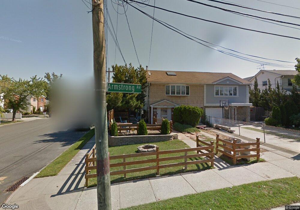
1039 Armstrong Ave Staten Island, NY 10308
Great Kills NeighborhoodEstimated Value: $640,082 - $828,000
--
Bed
4
Baths
1,244
Sq Ft
$586/Sq Ft
Est. Value
About This Home
This home is located at 1039 Armstrong Ave, Staten Island, NY 10308 and is currently estimated at $728,771, approximately $585 per square foot. 1039 Armstrong Ave is a home located in Richmond County with nearby schools including P.S. 32 The Gifford School, I.S. 075 Frank D. Paulo, and Susan E Wagner High School.
Ownership History
Date
Name
Owned For
Owner Type
Purchase Details
Closed on
Oct 17, 2003
Sold by
Turco Joann
Bought by
Gomez Patsy M
Current Estimated Value
Home Financials for this Owner
Home Financials are based on the most recent Mortgage that was taken out on this home.
Original Mortgage
$292,000
Interest Rate
6.05%
Mortgage Type
Unknown
Create a Home Valuation Report for This Property
The Home Valuation Report is an in-depth analysis detailing your home's value as well as a comparison with similar homes in the area
Home Values in the Area
Average Home Value in this Area
Purchase History
| Date | Buyer | Sale Price | Title Company |
|---|---|---|---|
| Gomez Patsy M | $385,000 | First American Title Insuran |
Source: Public Records
Mortgage History
| Date | Status | Borrower | Loan Amount |
|---|---|---|---|
| Previous Owner | Gomez Patsy M | $292,000 |
Source: Public Records
Tax History Compared to Growth
Tax History
| Year | Tax Paid | Tax Assessment Tax Assessment Total Assessment is a certain percentage of the fair market value that is determined by local assessors to be the total taxable value of land and additions on the property. | Land | Improvement |
|---|---|---|---|---|
| 2025 | $5,532 | $41,700 | $5,789 | $35,911 |
| 2024 | $5,544 | $39,780 | $6,068 | $33,712 |
| 2023 | $5,550 | $28,727 | $6,096 | $22,631 |
| 2022 | $5,123 | $31,980 | $8,340 | $23,640 |
| 2021 | $5,078 | $31,320 | $8,340 | $22,980 |
| 2020 | $4,809 | $28,920 | $8,340 | $20,580 |
| 2019 | $4,753 | $27,600 | $8,340 | $19,260 |
| 2018 | $4,582 | $23,939 | $6,889 | $17,050 |
| 2017 | $4,304 | $22,584 | $8,261 | $14,323 |
| 2016 | $3,949 | $21,306 | $7,259 | $14,047 |
| 2015 | $3,552 | $20,100 | $6,960 | $13,140 |
| 2014 | $3,552 | $20,100 | $6,960 | $13,140 |
Source: Public Records
Map
Nearby Homes
- 26 E Brandis Ave
- 74 E Brandis Ave
- 350 Brookfield Ave
- 379 Brookfield Ave
- 467 Ridgewood Ave
- 443 Ridgewood Ave
- 466 Doane Ave
- 88 Cortelyou Ave
- 339 Abingdon Ave
- 919 Armstrong Ave
- 924 Armstrong Ave Unit 2-3
- 131 Cortelyou Ave Unit 1-1
- 307 Abingdon Ave
- 259 Brookfield Ave
- 543 Eltingville Blvd
- 414 Elverton Ave
- 72 Eric Ln
- 345 Colon Ave
- 12 Lexington Ln
- 87 Pemberton Ave
- 1037 Armstrong Ave
- 1033 Armstrong Ave
- 386 Gurley Ave
- 1031 Armstrong Ave
- 384 Gurley Ave
- 393 Gurley Ave
- 395 Gurley Ave
- 380 Gurley Ave
- 1025 Armstrong Ave
- 378 Gurley Ave
- 387 Gurley Ave
- 39 E Brandis Ave
- 1063 Armstrong Ave Unit 2
- 1063 Armstrong Ave
- 1061 Armstrong Ave
- 1021 Armstrong Ave
- 383 Gurley Ave
- 37 E Brandis Ave
- 376 Gurley Ave
- 35 E Brandis Ave