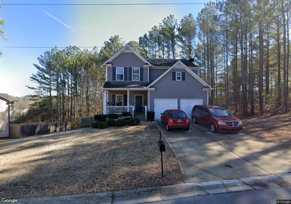
1039 West Ave Dallas, GA 30157
Estimated Value: $284,000 - $371,322
3
Beds
3
Baths
1,794
Sq Ft
$176/Sq Ft
Est. Value
About This Home
This home is located at 1039 West Ave, Dallas, GA 30157 and is currently estimated at $315,831, approximately $176 per square foot. 1039 West Ave is a home located in Paulding County with nearby schools including Allgood Elementary School, Herschel Jones Middle School, and Paulding County High School.
Ownership History
Date
Name
Owned For
Owner Type
Purchase Details
Closed on
Mar 4, 2020
Sold by
Luxor Sfr Spv 1 Llc
Bought by
Alto Asset Co 2 Llc
Current Estimated Value
Purchase Details
Closed on
Jan 16, 2019
Sold by
Jeff 1 Llc
Bought by
Luxor Sfr Spv 1 Llc and C/O Luxor Capital Grp Lp
Purchase Details
Closed on
Aug 28, 2018
Sold by
Piedmont Residential Llc
Bought by
Piedmont Leasing Llc
Purchase Details
Closed on
Dec 22, 2016
Sold by
Silver Comet Holding Co Ll
Bought by
Piedmont Residential Llc
Purchase Details
Closed on
May 16, 2016
Sold by
Res Gascc Llc
Bought by
Silver Comet Holding Co Llc
Create a Home Valuation Report for This Property
The Home Valuation Report is an in-depth analysis detailing your home's value as well as a comparison with similar homes in the area
Home Values in the Area
Average Home Value in this Area
Purchase History
| Date | Buyer | Sale Price | Title Company |
|---|---|---|---|
| Alto Asset Co 2 Llc | $10,010,925 | -- | |
| Luxor Sfr Spv 1 Llc | $355,190 | -- | |
| Piedmont Leasing Llc | -- | -- | |
| Lhf 4 Assets Llc | $309,500 | -- | |
| Piedmont Residential Llc | $55,200 | -- | |
| Silver Comet Holding Co Llc | $217,000 | -- |
Source: Public Records
Tax History Compared to Growth
Tax History
| Year | Tax Paid | Tax Assessment Tax Assessment Total Assessment is a certain percentage of the fair market value that is determined by local assessors to be the total taxable value of land and additions on the property. | Land | Improvement |
|---|---|---|---|---|
| 2024 | $4,217 | $135,136 | $12,000 | $123,136 |
| 2023 | $2,652 | $87,696 | $12,000 | $75,696 |
| 2022 | $2,286 | $87,696 | $12,000 | $75,696 |
| 2021 | $2,548 | $87,696 | $12,000 | $75,696 |
| 2020 | $2,472 | $79,288 | $12,000 | $67,288 |
| 2019 | $2,236 | $72,436 | $12,000 | $60,436 |
| 2018 | $181 | $6,000 | $6,000 | $0 |
| 2017 | $383 | $11,040 | $11,040 | $0 |
| 2016 | $44 | $1,280 | $1,280 | $0 |
| 2015 | $39 | $1,280 | $1,280 | $0 |
| 2014 | $40 | $1,280 | $1,280 | $0 |
| 2013 | -- | $1,280 | $1,280 | $0 |
Source: Public Records
Map
Nearby Homes
- 0 Cole Lake Rd Unit 7651259
- 0 Cole Lake Rd Unit 10607141
- 361 West Ave
- 298 Buchanan Hwy
- 60 Westside Cir
- 380 Buchanan Hwy
- 120 Remington Place Blvd
- 212 Remington Place Blvd
- 102 Natalie Ct
- 1119 W Memorial Dr
- 305 Remington Place Blvd
- 47 Whitley Ct
- 107 Salem Place
- Robie Plan at Oakleigh Glen
- Penwell Plan at Oakleigh Glen
- Belhaven Plan at Oakleigh Glen
- Darwin Plan at Oakleigh Glen
- Aria Plan at Oakleigh Glen
- 98 Shawnee Trail Unit 30
- 98 Shawnee Trail
- 1025 West Ave
- 1013 West Ave
- 120 Mount Comet Ct Unit 2
- 257 Cole Lake Rd
- 995 West Ave
- 118 Mount Comet Ct
- 119 Mount Comet Ct
- 250 Cole Lake Rd
- 981 West Ave
- 1094 West Ave
- 117 Mount Comet Ct
- 117 Mount Comet Ct Unit 144
- 316 Trailside Dr
- 116 Mount Comet Ct
- 969 West Ave
- 172 Cole Lake Rd
- 165 Cole Lake Rd
- 314 Trailside Dr Unit 2
- 115 Mount Comet Ct
- 318 Trailside Dr