Estimated Value: $678,162 - $756,000
3
Beds
3
Baths
2,015
Sq Ft
$358/Sq Ft
Est. Value
About This Home
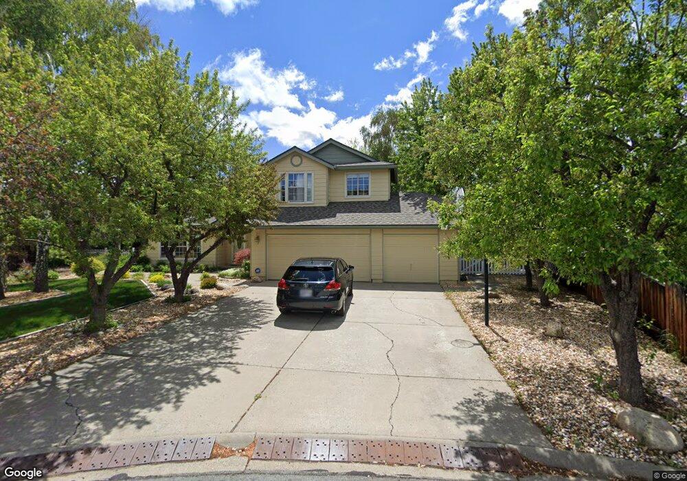
This home is located at 10390 Nighthawk Cir, Reno, NV 89523 and is currently estimated at $720,541, approximately $357 per square foot. 10390 Nighthawk Cir is a home located in Washoe County with nearby schools including Verdi Elementary School, B D Billinghurst Middle School, and Robert McQueen High School.
Ownership History
Date
Name
Owned For
Owner Type
Purchase Details
Closed on
Dec 9, 2020
Sold by
Jeffery James J and Jeffery Polly A
Bought by
Jeffery James Joshua and Jeffery Polly Ann
Current Estimated Value
Purchase Details
Closed on
Jun 20, 2017
Sold by
Phillips Keith A and Phillips Sharon M
Bought by
Jeffery James J and Jeffery Polly A
Create a Home Valuation Report for This Property
The Home Valuation Report is an in-depth analysis detailing your home's value as well as a comparison with similar homes in the area
Home Values in the Area
Average Home Value in this Area
Purchase History
| Date | Buyer | Sale Price | Title Company |
|---|---|---|---|
| Jeffery James Joshua | -- | None Available | |
| Jeffery James J | $920,000 | First American Title Reno |
Source: Public Records
Mortgage History
| Date | Status | Borrower | Loan Amount |
|---|---|---|---|
| Closed | Jeffery James J | $0 |
Source: Public Records
Tax History
| Year | Tax Paid | Tax Assessment Tax Assessment Total Assessment is a certain percentage of the fair market value that is determined by local assessors to be the total taxable value of land and additions on the property. | Land | Improvement |
|---|---|---|---|---|
| 2026 | $1,974 | $112,939 | $56,840 | $56,099 |
| 2024 | $2,492 | $113,073 | $54,250 | $58,823 |
| 2023 | $2,492 | $108,633 | $52,675 | $55,958 |
| 2022 | $2,420 | $90,209 | $43,085 | $47,124 |
| 2021 | $2,351 | $79,577 | $32,270 | $47,307 |
| 2020 | $2,279 | $79,279 | $31,500 | $47,779 |
| 2019 | $2,171 | $75,613 | $29,050 | $46,563 |
| 2018 | $2,070 | $69,391 | $23,450 | $45,941 |
| 2017 | $1,989 | $63,824 | $17,430 | $46,394 |
| 2016 | $1,909 | $62,367 | $16,905 | $45,462 |
| 2015 | $1,906 | $60,841 | $15,190 | $45,651 |
| 2014 | $1,850 | $59,606 | $15,540 | $44,066 |
| 2013 | -- | $55,182 | $11,585 | $43,597 |
Source: Public Records
Map
Nearby Homes
- 220 Lemming Dr
- 40 Eagle Claw Ct
- 415 Gooseberry Dr
- 280 Eucalyptus Ct
- 80 Bobcat Dr
- 1660 Boulder Ridge Ct
- 0 Mountain Haven Ln
- 1290 Firefly Ct
- 8726 Larkhaven Ct
- 1068 Callaway Trail
- 865 Larrimore Trail
- 1527 Elk Run Trail
- 9225 Sassafras Trail
- 1539 Elk Run Trail
- 8778 Larkhaven Trail
- 8775 Twelve Moons Ct
- 1140 Sugar Creek Trail
- 1075 Udowski Ct
- 1725 Verdi Vista Ct
- 1165 Sugar Creek Trail
- 200 Moonshine Cir
- 10400 Nighthawk Cir
- 750 Cliff View Dr
- 180 Moonshine Cir
- 10385 Mountain Dew Cir
- 230 Moonshine Cir
- 10395 Nighthawk Cir
- 760 Cliff View Dr
- 10415 Nighthawk Cir
- 10375 Mountain Dew Cir
- 175 Moonshine Cir
- 240 Moonshine Cir
- 735 Cliff View Dr
- 745 Cliff View Dr
- 185 Moonshine Cir
- 195 Moonshine Cir
- 680 Cliff View Dr
- 10355 Mountain Dew Cir
- 215 Moonshine Cir
- 755 Cliff View Dr
Your Personal Tour Guide
Ask me questions while you tour the home.