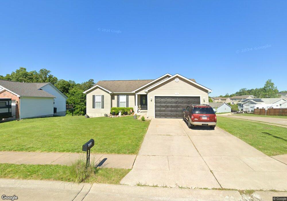
10391 Hawks Nest Dr Hillsboro, MO 63050
Estimated Value: $273,000 - $288,130
3
Beds
2
Baths
1,254
Sq Ft
$227/Sq Ft
Est. Value
About This Home
This home is located at 10391 Hawks Nest Dr, Hillsboro, MO 63050 and is currently estimated at $284,033, approximately $226 per square foot. 10391 Hawks Nest Dr is a home located in Jefferson County with nearby schools including Hillsboro Elementary School, Hillsboro Primary School, and Hillsboro Middle Elementary School.
Ownership History
Date
Name
Owned For
Owner Type
Purchase Details
Closed on
Jul 10, 2020
Sold by
Brod Nancy J and The Brod Family Living Tust
Bought by
Battles Cathy D
Current Estimated Value
Purchase Details
Closed on
Jan 22, 2013
Sold by
Fannie Mae
Bought by
Brod David A and Brod Nancy J
Purchase Details
Closed on
Sep 6, 2012
Sold by
Guethle Matthwe T and Guethle Krystal
Bought by
Federal National Mortgage Association
Purchase Details
Closed on
Jul 27, 2006
Sold by
Alpha Omega Ventures Llc
Bought by
Guethle Matthew T and Guethle Krystal
Home Financials for this Owner
Home Financials are based on the most recent Mortgage that was taken out on this home.
Original Mortgage
$159,900
Interest Rate
6.62%
Mortgage Type
Purchase Money Mortgage
Create a Home Valuation Report for This Property
The Home Valuation Report is an in-depth analysis detailing your home's value as well as a comparison with similar homes in the area
Home Values in the Area
Average Home Value in this Area
Purchase History
| Date | Buyer | Sale Price | Title Company |
|---|---|---|---|
| Battles Cathy D | -- | None Available | |
| Brod David A | -- | None Available | |
| Federal National Mortgage Association | $127,249 | None Available | |
| Guethle Matthew T | -- | Commonwealth Land Title |
Source: Public Records
Mortgage History
| Date | Status | Borrower | Loan Amount |
|---|---|---|---|
| Previous Owner | Guethle Matthew T | $159,900 |
Source: Public Records
Tax History Compared to Growth
Tax History
| Year | Tax Paid | Tax Assessment Tax Assessment Total Assessment is a certain percentage of the fair market value that is determined by local assessors to be the total taxable value of land and additions on the property. | Land | Improvement |
|---|---|---|---|---|
| 2025 | $2,297 | $40,500 | $7,000 | $33,500 |
| 2024 | $2,297 | $37,200 | $7,000 | $30,200 |
| 2023 | $2,297 | $37,200 | $7,000 | $30,200 |
| 2022 | $2,019 | $32,600 | $7,000 | $25,600 |
| 2021 | $2,166 | $32,600 | $7,000 | $25,600 |
| 2020 | $1,976 | $28,900 | $6,100 | $22,800 |
| 2019 | $1,974 | $28,900 | $6,100 | $22,800 |
| 2018 | $1,984 | $28,900 | $6,100 | $22,800 |
| 2017 | $1,989 | $28,900 | $6,100 | $22,800 |
| 2016 | $1,953 | $27,000 | $6,000 | $21,000 |
| 2015 | $1,940 | $27,000 | $6,000 | $21,000 |
| 2013 | $1,940 | $26,800 | $6,000 | $20,800 |
Source: Public Records
Map
Nearby Homes
- 314 Hawks Perch Place
- 10401 Highway Bb
- 10430 Business 21
- 0 Lot 62 01 Acres Unit 23042037
- 719 Camelot Estates Dr
- 0 Brickyard Rd
- 712 Maple St
- 32 Ridgewood Dr
- 10515 Eagles Nest Dr
- 10509 Acorn Dr
- 10284 Micah Ln
- 5600 Forest Dr
- 569 Karen Dr
- 5653 Forest Dr
- 5665 Forest Dr
- 4799 State Road B
- 10401 Lake Crest Dr
- 5683 Forest Dr
- 9449 Hillsboro-House Springs Rd
- 10201 Lake Hill Trail
- 0Lot 201 Hawks Landing
- 0Lot 202 Hawks Landing
- 10395 Hawks Nest Dr
- 5610 Hawks Landing Dr
- 10385 Hawks Nest Dr
- 5605 Hawks Landing Dr
- 728 Hawks Circle Dr
- 802 Hawks Circle Dr
- 5614 Hawks Landing Dr
- 5609 Hawks Landing Dr
- 10390 Hawks Nest Dr
- 724 Hawks Circle Dr
- 10381 Hawks Nest Dr
- 10386 Hawks Nest Dr
- 806 Hawks Circle Dr
- 5613 Hawks Landing (Lot 10) Dr
- 5613 Hawks Landing Dr
- 0LOT 167 Hawks Circle Dr
- 720 Hawks Circle Dr
- 5618 Hawks Landing Dr