
104 1st Ave Hightstown, NJ 08520
Estimated payment $3,280/month
Highlights
- Colonial Architecture
- No HOA
- Tankless Water Heater
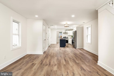
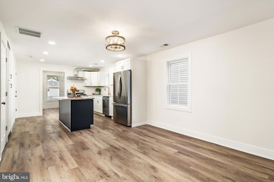
- Engineered Wood Flooring
- Living Room
- Kitchen Island
About This Home
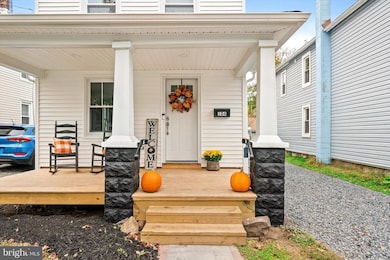
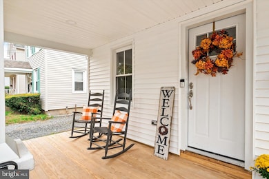
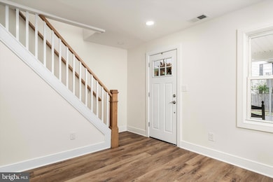
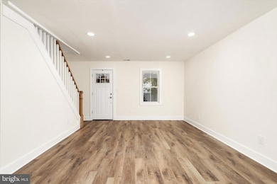
Fully renovated single family home in the heart of Hightstown Boro. Property was stripped to the studs and updated to include every expected modern amenity. All new insulation, sheetrock, roof, siding and windows. Enjoy peace of mind with brand new forced air HVAC with central air, all new plumbing and electrical. An open floor plan with newly vaulted second floor ceilings and recessed lighting gives this home all the features a buyer is looking for. The brand-new kitchen and bathrooms showcase modern finishes and quality craftsmanship throughout. Relax and unwind on the charming front porch, perfect for morning coffee or evening sunsets. Every detail has been thoughtfully chosen. This home is truly move-in ready! More can be said but you really need to see for yourself. Call the listing agent for a showing before it’s gone.

Home Details
Home Type
- Single Family
Est. Annual Taxes
- $8,210
Year Built
- Built in 1900 | Remodeled in 2025
Lot Details
- 3,598 Sq Ft Lot
- Lot Dimensions are 30.00 x 120.00
- Property is Fully Fenced
- Back Yard
- Property is in excellent condition
- Property is zoned R-4
Home Design
- Colonial Architecture
- Shingle Roof
- Vinyl Siding
Interior Spaces
- 1,388 Sq Ft Home
- Property has 2 Levels
- Ceiling height of 9 feet or more
- Family Room
- Living Room
- Dining Room
- Engineered Wood Flooring
Kitchen
- Self-Cleaning Oven
- Microwave
- Dishwasher
- Kitchen Island
Bedrooms and Bathrooms
- 3 Bedrooms
Basement
- Partial Basement
- Laundry in Basement
Parking
- 2 Parking Spaces
- 2 Driveway Spaces
- Stone Driveway
Schools
- Hightstown School
Utilities
- Forced Air Heating and Cooling System
- Tankless Water Heater
Community Details
- No Home Owners Association
Listing and Financial Details
- Tax Lot 00002
- Assessor Parcel Number 04-00042-00002
Map
Home Values in the Area
Average Home Value in this Area
Tax History
| Year | Tax Paid | Tax Assessment Tax Assessment Total Assessment is a certain percentage of the fair market value that is determined by local assessors to be the total taxable value of land and additions on the property. | Land | Improvement |
|---|---|---|---|---|
| 2025 | $7,879 | $160,700 | $59,000 | $101,700 |
| 2024 | $7,799 | $160,700 | $59,000 | $101,700 |
| 2023 | $7,799 | $160,700 | $59,000 | $101,700 |
| 2022 | $7,529 | $160,700 | $59,000 | $101,700 |
| 2021 | $7,257 | $160,700 | $59,000 | $101,700 |
| 2020 | $7,092 | $160,700 | $59,000 | $101,700 |
| 2019 | $6,894 | $160,700 | $59,000 | $101,700 |
| 2018 | $6,693 | $160,700 | $59,000 | $101,700 |
| 2017 | $6,624 | $160,700 | $59,000 | $101,700 |
| 2016 | $6,566 | $160,700 | $59,000 | $101,700 |
| 2015 | $6,524 | $160,700 | $59,000 | $101,700 |
| 2014 | $6,566 | $160,700 | $59,000 | $101,700 |
Property History
| Date | Event | Price | List to Sale | Price per Sq Ft |
|---|---|---|---|---|
| 10/31/2025 10/31/25 | For Sale | $495,000 | -- | $357 / Sq Ft |
Purchase History
| Date | Type | Sale Price | Title Company |
|---|---|---|---|
| Deed | $115,000 | Etitle Solutions | |
| Deed | $115,000 | Etitle Solutions | |
| Deed | -- | -- |
Source: Bright MLS
MLS Number: NJME2069176
APN: 04-00042-0000-00002
Disclaimer: Certain information contained herein is derived from information provided by parties other than Homes.com. All information provided is deemed reliable, but is not guaranteed to be accurate and should be independently verified.
![]() The data relating to real estate for sale on this website appears in part through the BRIGHT Internet Data Exchange program, a voluntary cooperative exchange of property listing data between licensed real estate brokerage firms, and is provided by BRIGHT through a licensing agreement.
The data relating to real estate for sale on this website appears in part through the BRIGHT Internet Data Exchange program, a voluntary cooperative exchange of property listing data between licensed real estate brokerage firms, and is provided by BRIGHT through a licensing agreement.
Listing information is from various brokers who participate in the Bright MLS IDX program and not all listings may be visible on the site.
The property information being provided on or through the website is for the personal, non-commercial use of consumers and such information may not be used for any purpose other than to identify prospective properties consumers may be interested in purchasing.
Some properties which appear for sale on the website may no longer be available because they are for instance, under contract, sold or are no longer being offered for sale.
Property information displayed is deemed reliable but is not guaranteed.
Copyright 2025 Bright MLS, Inc.
- 201 Morrison Ave
- 336 Stockton St
- 365 Stockton St
- 302 S Main St
- 309 Lincoln Ave
- 141 Lincoln Ave
- 145 Lincoln Ave
- 400 Stockton St
- 107 Hausser Ave
- 128 Monmouth St
- 219 Maxwell Ave
- 344 Monmouth St
- 108 Orchard Ave
- 0 Route 130
- 23 Barton Dr
- 4 Sandstone Rd
- 5 Mill Run W
- 4 Brakeman Ct
- 102 Teal Ct
- 158 Mill Run E
- 126 Stockton St
- 400 Stockton St
- 9 Deerfield Park
- 17 Winchester Dr
- 5 Mill Run W
- 23 Powell Ct
- 1 Schindler Dr
- B23 Garden View Terrace
- 47 4 Garden View Terrace Unit 4
- 43-19 Garden View Terrace
- 47 Garden View Terrace Unit 11
- 47 Garden View Terrace Unit 4
- 3 Keats Ct
- 51 Garden View Terrace Unit 2
- 11 Tennyson Rd
- 152 Hickory Corner Rd
- 35 Brooktree Rd
- 174 One Mile Rd E
- 400 Dutch Neck Rd
- 1914 Old Stone Mill Dr