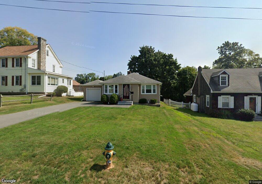
104 Barbara Rd Middletown, CT 06457
Westfield NeighborhoodEstimated Value: $267,304 - $303,000
2
Beds
1
Bath
839
Sq Ft
$335/Sq Ft
Est. Value
About This Home
This home is located at 104 Barbara Rd, Middletown, CT 06457 and is currently estimated at $281,076, approximately $335 per square foot. 104 Barbara Rd is a home located in Middlesex County with nearby schools including Spencer School, Middletown High School, and St John Paul II School.
Ownership History
Date
Name
Owned For
Owner Type
Purchase Details
Closed on
Jun 29, 2007
Sold by
Liburdi Tara
Bought by
Mascaro Keith J
Current Estimated Value
Home Financials for this Owner
Home Financials are based on the most recent Mortgage that was taken out on this home.
Original Mortgage
$172,550
Outstanding Balance
$105,868
Interest Rate
6.24%
Estimated Equity
$175,208
Purchase Details
Closed on
Jul 2, 2001
Sold by
Landry Nicole L
Bought by
Liburdi Tara E
Home Financials for this Owner
Home Financials are based on the most recent Mortgage that was taken out on this home.
Original Mortgage
$113,000
Interest Rate
7.14%
Purchase Details
Closed on
Jul 11, 1996
Sold by
Plato Theresa A
Bought by
Landry Nicole L
Home Financials for this Owner
Home Financials are based on the most recent Mortgage that was taken out on this home.
Original Mortgage
$82,800
Interest Rate
7.98%
Mortgage Type
Unknown
Create a Home Valuation Report for This Property
The Home Valuation Report is an in-depth analysis detailing your home's value as well as a comparison with similar homes in the area
Home Values in the Area
Average Home Value in this Area
Purchase History
| Date | Buyer | Sale Price | Title Company |
|---|---|---|---|
| Mascaro Keith J | $182,000 | -- | |
| Liburdi Tara E | $113,000 | -- | |
| Landry Nicole L | $84,000 | -- |
Source: Public Records
Mortgage History
| Date | Status | Borrower | Loan Amount |
|---|---|---|---|
| Open | Landry Nicole L | $172,550 | |
| Previous Owner | Landry Nicole L | $112,000 | |
| Previous Owner | Landry Nicole L | $113,000 | |
| Previous Owner | Landry Nicole L | $82,800 | |
| Closed | Landry Nicole L | $4,200 |
Source: Public Records
Tax History
| Year | Tax Paid | Tax Assessment Tax Assessment Total Assessment is a certain percentage of the fair market value that is determined by local assessors to be the total taxable value of land and additions on the property. | Land | Improvement |
|---|---|---|---|---|
| 2025 | $5,082 | $130,640 | $56,510 | $74,130 |
| 2024 | $4,808 | $130,640 | $56,510 | $74,130 |
| 2023 | $4,585 | $130,640 | $56,510 | $74,130 |
| 2022 | $3,988 | $90,630 | $37,670 | $52,960 |
| 2021 | $3,988 | $90,630 | $37,670 | $52,960 |
| 2020 | $4,006 | $90,630 | $37,670 | $52,960 |
| 2019 | $4,024 | $90,630 | $37,670 | $52,960 |
| 2018 | $3,961 | $90,630 | $37,670 | $52,960 |
| 2017 | $3,980 | $93,870 | $40,370 | $53,500 |
| 2016 | $3,867 | $93,870 | $40,370 | $53,500 |
| 2015 | $3,717 | $93,870 | $40,370 | $53,500 |
| 2014 | $3,755 | $93,870 | $40,370 | $53,500 |
Source: Public Records
Map
Nearby Homes
- 27 Barbara Rd
- 8 Nathan Hale Rd
- 1 Nathan Hale Rd
- 4 Nathan Hale Rd
- 3 Nathan Hale Rd
- 5 Nathan Hale Rd
- 160 Boston Rd
- 82 Westfield Terrace
- 194 Camp St
- 211 Boston Rd
- 21 Butternut Knolls
- 146 Liberty St
- 132 Grand St
- 45 Mckenna Dr
- 60 Sonoma Ln
- 565 High St
- 183 Aston Ln
- 177 Pearl St
- 207 Pearl St
- 94 Cynthia Ln Unit A6
Your Personal Tour Guide
Ask me questions while you tour the home.