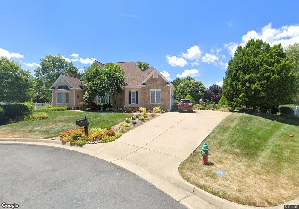
104 Bing Ct Winchester, VA 22602
Estimated Value: $575,707 - $632,000
3
Beds
3
Baths
2,339
Sq Ft
$258/Sq Ft
Est. Value
About This Home
This home is located at 104 Bing Ct, Winchester, VA 22602 and is currently estimated at $602,927, approximately $257 per square foot. 104 Bing Ct is a home located in Frederick County with nearby schools including Admiral Richard E. Byrd Middle School, Millbrook High School, and Sharon's Centre.
Ownership History
Date
Name
Owned For
Owner Type
Purchase Details
Closed on
Dec 20, 2024
Sold by
Sillitto Ann E
Bought by
Peter And Ann Sillitto Living Trust and Sillitto
Current Estimated Value
Purchase Details
Closed on
May 10, 2001
Sold by
Patriot Homes Inc
Bought by
Sillitto Peter N
Home Financials for this Owner
Home Financials are based on the most recent Mortgage that was taken out on this home.
Original Mortgage
$100,000
Interest Rate
6.88%
Create a Home Valuation Report for This Property
The Home Valuation Report is an in-depth analysis detailing your home's value as well as a comparison with similar homes in the area
Home Values in the Area
Average Home Value in this Area
Purchase History
| Date | Buyer | Sale Price | Title Company |
|---|---|---|---|
| Peter And Ann Sillitto Living Trust | -- | None Listed On Document | |
| Sillitto Peter N | $327,026 | -- |
Source: Public Records
Mortgage History
| Date | Status | Borrower | Loan Amount |
|---|---|---|---|
| Previous Owner | Sillitto Peter N | $100,000 |
Source: Public Records
Tax History Compared to Growth
Tax History
| Year | Tax Paid | Tax Assessment Tax Assessment Total Assessment is a certain percentage of the fair market value that is determined by local assessors to be the total taxable value of land and additions on the property. | Land | Improvement |
|---|---|---|---|---|
| 2025 | $2,672 | $556,700 | $113,000 | $443,700 |
| 2024 | $1,246 | $481,600 | $97,000 | $384,600 |
| 2023 | $2,456 | $481,600 | $97,000 | $384,600 |
| 2022 | $2,209 | $362,200 | $92,000 | $270,200 |
| 2021 | $2,249 | $362,200 | $92,000 | $270,200 |
| 2020 | $2,034 | $326,900 | $92,000 | $234,900 |
| 2019 | $2,034 | $326,900 | $92,000 | $234,900 |
| 2018 | $2,087 | $334,800 | $92,000 | $242,800 |
| 2017 | $2,069 | $334,800 | $92,000 | $242,800 |
| 2016 | $1,972 | $318,700 | $89,500 | $229,200 |
| 2015 | $1,785 | $318,700 | $89,500 | $229,200 |
| 2014 | $972 | $294,500 | $89,500 | $205,000 |
Source: Public Records
Map
Nearby Homes
- 210 Darby Dr
- 113 Shockey Cir
- 122 Poe Dr
- 132 Cahille Dr
- 127 Kinross Dr
- 220 Flanagan Dr
- 229 Taggart Dr
- 219 Taggart Dr
- 226 Taggart Dr
- 103 Derrynan Ct
- 120 Armstrong Place
- 108 Kinross Dr
- 126 Armstrong Place
- 123 Etnam St
- 206 Custer Ave
- 105 Lenore Ln
- 121 Raven Oaks Dr
- 128 Raven Oaks Dr
- 128 Nevermore Dr
- 301 Yale Dr
- 0 Bing Ct Unit FV3187558
- 0 Bing Ct Unit FV3187559
- 0 Bing Ct Unit FV3378564
- 105 Bing Ct
- 102 Bing Ct
- 212 Darby Dr
- 216 Darby Dr
- 103 Bing Ct
- 218 Darby Dr
- 107 Bramble Ct
- 100 Bing Ct
- 120 Dewberry Dr
- 118 Dewberry Dr
- 208 Darby Dr
- 101 Bing Ct
- 109 Bramble Ct
- 111 Bramble Ct
- 0 Bramble Ct Unit FV4211390
- 112 Dewberry Dr
- 124 Dewberry Dr