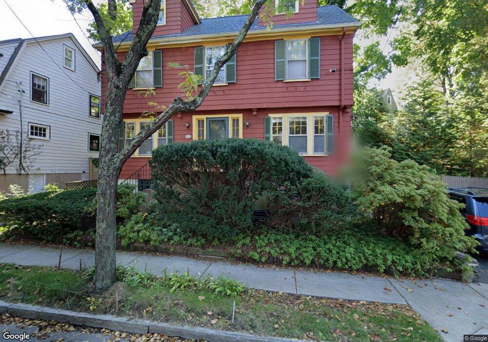
104 Clark Rd Brookline, MA 02445
Brookline Village NeighborhoodEstimated Value: $1,881,000 - $2,437,000
4
Beds
3
Baths
2,169
Sq Ft
$976/Sq Ft
Est. Value
About This Home
This home is located at 104 Clark Rd, Brookline, MA 02445 and is currently estimated at $2,115,992, approximately $975 per square foot. 104 Clark Rd is a home located in Norfolk County with nearby schools including John D. Runkle School, Maimonides School, and St. Mary of the Assumption Elementary School.
Ownership History
Date
Name
Owned For
Owner Type
Purchase Details
Closed on
Feb 5, 1993
Sold by
Kaplan Elizabeth A and Kaplan Lawrence E
Bought by
Guitell Andrew H and Guitell Karen S
Current Estimated Value
Home Financials for this Owner
Home Financials are based on the most recent Mortgage that was taken out on this home.
Original Mortgage
$130,000
Interest Rate
8.1%
Mortgage Type
Purchase Money Mortgage
Create a Home Valuation Report for This Property
The Home Valuation Report is an in-depth analysis detailing your home's value as well as a comparison with similar homes in the area
Home Values in the Area
Average Home Value in this Area
Purchase History
| Date | Buyer | Sale Price | Title Company |
|---|---|---|---|
| Guitell Andrew H | $290,000 | -- |
Source: Public Records
Mortgage History
| Date | Status | Borrower | Loan Amount |
|---|---|---|---|
| Open | Guitell Andrew H | $256,090 | |
| Closed | Guitell Andrew H | $130,000 | |
| Closed | Guitell Andrew H | $130,000 |
Source: Public Records
Tax History Compared to Growth
Tax History
| Year | Tax Paid | Tax Assessment Tax Assessment Total Assessment is a certain percentage of the fair market value that is determined by local assessors to be the total taxable value of land and additions on the property. | Land | Improvement |
|---|---|---|---|---|
| 2025 | $18,799 | $1,904,700 | $1,152,300 | $752,400 |
| 2024 | $17,880 | $1,830,100 | $1,107,900 | $722,200 |
| 2023 | $14,950 | $1,499,500 | $791,600 | $707,900 |
| 2022 | $14,552 | $1,428,100 | $753,900 | $674,200 |
| 2021 | $13,457 | $1,373,200 | $724,900 | $648,300 |
| 2020 | $12,263 | $1,297,700 | $659,000 | $638,700 |
| 2019 | $11,580 | $1,235,900 | $627,600 | $608,300 |
| 2018 | $11,510 | $1,216,700 | $624,300 | $592,400 |
| 2017 | $11,427 | $1,156,600 | $588,900 | $567,700 |
| 2016 | $11,263 | $1,080,900 | $550,400 | $530,500 |
| 2015 | $10,789 | $1,010,200 | $514,400 | $495,800 |
| 2014 | $10,884 | $955,600 | $467,600 | $488,000 |
Source: Public Records
Map
Nearby Homes
- 105 Sumner Rd
- 487 Boylston St Unit 3
- 371 Walnut St
- 87 Greenough St Unit 1
- 87 Greenough St Unit 2
- 71 Greenough St Unit 71-1
- 255 Tappan St
- 469 Walnut St
- 15 Colbourne Crescent Unit 2
- 90 Addington Rd Unit 1
- 184 Rawson Rd
- 72 Cypress St Unit 1
- 108-116 Winthrop Rd
- 12 Colbourne Crescent Unit 1
- 84 Winthrop Rd Unit 1
- 84 Winthrop Rd
- 80 Dudley St
- 55 Leicester St
- 21 Hancock Rd
- 9 Greenough St