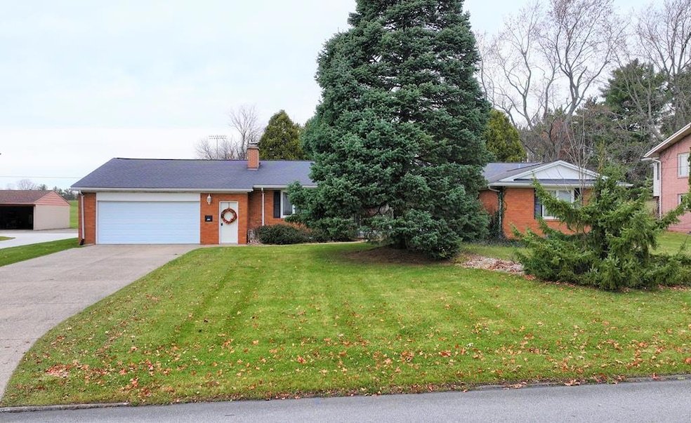
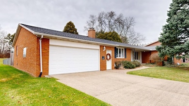


104 Elmridge Rd Mansfield, OH 44907
Estimated payment $1,623/month
Highlights
- Wood Burning Stove
- Ranch Style House
- Double Pane Windows
- Recreation Room
- 2 Car Attached Garage
- Walk-In Closet
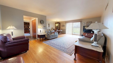
About This Home
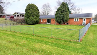
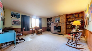
Nicely maintained 2,466 sq. ft. ranch located conveniently behind Malabar School with quick access to St. Rt. 13 and St. Rt. 71. This spacious home offers 2 bedrooms, 2.5 baths, a massive living room and dining area, a comfortable family room with a fireplace, and a generously sized main-floor laundry. Additional highlights include a two-car attached garage, a partially finished walkout basement for extra living or storage space, and a fenced-in backyard perfect for pets, play, or outdoor relaxation. A well-kept property in a prime location!
Listing Agent
Wilson Family Realty Corp Brokerage Phone: 4195285500 License #418545 Listed on: 11/26/2025

Home Details
Home Type
- Single Family
Est. Annual Taxes
- $3,373
Year Built
- Built in 1966
Lot Details
- 0.34 Acre Lot
- Fenced
- Level Lot
Parking
- 2 Car Attached Garage
- Garage Door Opener
- Open Parking
Home Design
- Ranch Style House
- Brick Exterior Construction
- Vinyl Siding
Interior Spaces
- 2,466 Sq Ft Home
- Wood Burning Stove
- Double Pane Windows
- Dining Room
- Recreation Room
- Wall to Wall Carpet
- Fire and Smoke Detector
Kitchen
- Range
- Microwave
- Dishwasher
- Disposal
Bedrooms and Bathrooms
- 2 Main Level Bedrooms
- En-Suite Primary Bedroom
- Walk-In Closet
Laundry
- Laundry on main level
- Dryer
- Washer
Basement
- Walk-Out Basement
- Basement Fills Entire Space Under The House
- Sump Pump
Utilities
- Forced Air Heating and Cooling System
- Heating System Uses Natural Gas
- Gas Water Heater
Additional Features
- Patio
- City Lot
Listing and Financial Details
- Assessor Parcel Number 0270708509000
Map
Home Values in the Area
Average Home Value in this Area
Tax History
| Year | Tax Paid | Tax Assessment Tax Assessment Total Assessment is a certain percentage of the fair market value that is determined by local assessors to be the total taxable value of land and additions on the property. | Land | Improvement |
|---|---|---|---|---|
| 2024 | $3,373 | $81,840 | $8,550 | $73,290 |
| 2023 | $3,373 | $81,840 | $8,550 | $73,290 |
| 2022 | $2,998 | $62,410 | $7,460 | $54,950 |
| 2021 | $3,019 | $62,410 | $7,460 | $54,950 |
| 2020 | $3,087 | $62,410 | $7,460 | $54,950 |
| 2019 | $2,814 | $52,890 | $6,320 | $46,570 |
| 2018 | $2,776 | $52,890 | $6,320 | $46,570 |
| 2017 | $2,179 | $52,890 | $6,320 | $46,570 |
| 2016 | $1,657 | $35,010 | $6,320 | $28,690 |
| 2015 | $1,657 | $35,010 | $6,320 | $28,690 |
| 2014 | $1,562 | $35,010 | $6,320 | $28,690 |
| 2012 | $949 | $41,870 | $6,320 | $35,550 |
Property History
| Date | Event | Price | List to Sale | Price per Sq Ft |
|---|---|---|---|---|
| 11/26/2025 11/26/25 | For Sale | $254,900 | -- | $103 / Sq Ft |
Purchase History
| Date | Type | Sale Price | Title Company |
|---|---|---|---|
| Survivorship Deed | $121,000 | Chicago Title | |
| Deed | $90,000 | -- | |
| Deed | $74,000 | -- |
Mortgage History
| Date | Status | Loan Amount | Loan Type |
|---|---|---|---|
| Open | $91,000 | Purchase Money Mortgage |
Source: Mansfield Association of REALTORS®
MLS Number: 9070038
APN: 027-07-085-09-000
Disclaimer: Certain information contained herein is derived from information provided by parties other than Homes.com. All information provided is deemed reliable, but is not guaranteed to be accurate and should be independently verified.
![]() IDX information is provided exclusively for personal, non-commercial use, and may not be used for any purpose other than to identify prospective properties consumers may be interested in purchasing. Information is deemed reliable but not guaranteed.
IDX information is provided exclusively for personal, non-commercial use, and may not be used for any purpose other than to identify prospective properties consumers may be interested in purchasing. Information is deemed reliable but not guaranteed.
- 136 Elmridge Rd
- 1179 Burkwood Rd
- 1021 Burkwood Rd
- 33 Rambleside Dr
- 0 Lexington Ave Unit 224009661
- 1125 Larchwood Rd
- 65 Logan Rd
- 138 Cliffbrook Dr
- 674 Hillgrove Ave
- 400 James Ave
- 0 George Ave
- 484 Beechwood Dr
- 154 Elderberry Dr
- 148 Elderberry Dr
- 179 Chilton Ave
- 181 Chilton Ave
- 129 Elderberry Dr
- 1599 S Main St
- 506 Logan Rd
- 0 Yoha Dr
- 100 E Cook Rd
- 275 Cliffbrook Dr
- 478 E Cook Rd
- 733-793 Sunset Blvd
- 1386 Robinhood Ln Unit 7
- 587 Bailey Dr Unit 13
- 1665 Riva Ridge Dr
- 662 Bailey Dr
- 810 Betner Dr
- 300 Wood St Unit E7
- 283 Wood St
- 311 Greendale Ave
- 326 Poplar St
- 230 Sturges Ave
- 649 Straub Rd W
- 1806 Sawmill Place
- 211 S Foster St Unit 3
- 900 Max Ave
- 798 Straub Rd W
- 960 Sautter Dr Unit 960 Sautter Dr.