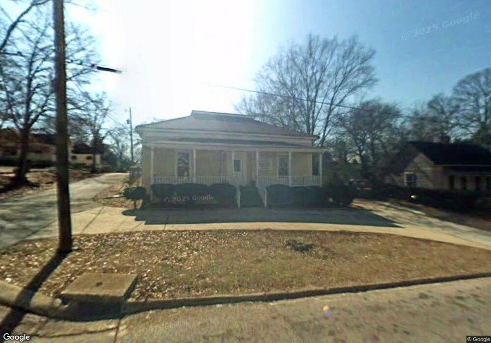
104 Fannin St Lagrange, GA 30241
--
Bed
1
Bath
2,680
Sq Ft
0.44
Acres
About This Home
This home is located at 104 Fannin St, Lagrange, GA 30241. 104 Fannin St is a home located in Troup County with nearby schools including Hollis Hand Elementary School, Franklin Forest Elementary School, and Ethel W. Kight Elementary School.
Ownership History
Date
Name
Owned For
Owner Type
Purchase Details
Closed on
Mar 23, 2022
Sold by
Woodard Willie J
Bought by
Woodard Yvette R
Purchase Details
Closed on
Jun 26, 1996
Sold by
Ellis A Spence
Bought by
Woodard Willie
Purchase Details
Closed on
May 4, 1996
Sold by
Virginia M Jordan
Bought by
Ellis A Spence
Purchase Details
Closed on
Mar 1, 1979
Sold by
Spence Ellis A
Bought by
Virginia M Jordan
Purchase Details
Closed on
Jan 1, 1969
Sold by
Milam Judson J
Bought by
Spence Ellis A
Create a Home Valuation Report for This Property
The Home Valuation Report is an in-depth analysis detailing your home's value as well as a comparison with similar homes in the area
Home Values in the Area
Average Home Value in this Area
Purchase History
| Date | Buyer | Sale Price | Title Company |
|---|---|---|---|
| Woodard Yvette R | -- | -- | |
| Woodard Willie | $70,000 | -- | |
| Ellis A Spence | -- | -- | |
| Virginia M Jordan | $4,000 | -- | |
| Spence Ellis A | -- | -- |
Source: Public Records
Tax History Compared to Growth
Tax History
| Year | Tax Paid | Tax Assessment Tax Assessment Total Assessment is a certain percentage of the fair market value that is determined by local assessors to be the total taxable value of land and additions on the property. | Land | Improvement |
|---|---|---|---|---|
| 2025 | $1,143 | $41,920 | $4,400 | $37,520 |
| 2024 | $1,143 | $41,920 | $4,400 | $37,520 |
| 2023 | $1,118 | $41,000 | $4,400 | $36,600 |
| 2022 | $1,144 | $41,000 | $4,400 | $36,600 |
| 2021 | $908 | $30,120 | $10,000 | $20,120 |
| 2020 | $908 | $30,120 | $10,000 | $20,120 |
| 2019 | $1,150 | $38,120 | $10,000 | $28,120 |
| 2018 | $1,150 | $38,120 | $10,000 | $28,120 |
| 2017 | $1,150 | $38,120 | $10,000 | $28,120 |
| 2016 | $1,280 | $42,452 | $10,000 | $32,452 |
| 2015 | $1,282 | $42,452 | $10,000 | $32,452 |
| 2014 | $1,285 | $42,452 | $10,000 | $32,452 |
| 2013 | -- | $29,460 | $9,000 | $20,460 |
Source: Public Records
Map
Nearby Homes
- 102 Fannin St
- 108 Fannin St
- 100 Fannin St
- 101 Gorham St
- 211 Whitesville St
- 105 Fannin St
- 100 Fairfax St
- 305 Whitesville St
- 301 Whitesville St
- 111 Fannin St
- 102 Fannin Ct
- 201 Gorham St
- 203 Gorham St
- 113 Fannin St
- 104 Fannin Ct
- 209 Whitesville St
- 100 Fannin Ct
- 106 Fannin Ct
- 206 Gorham St
- 115 Fannin St