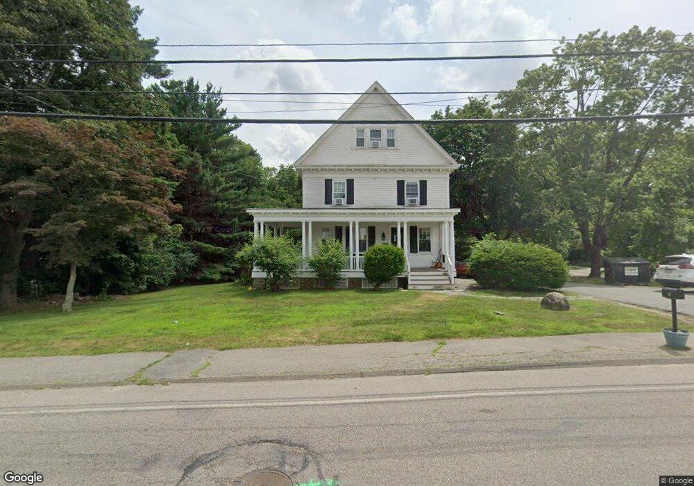
104 Highland Ave Attleboro, MA 02703
Estimated Value: $551,000 - $785,000
4
Beds
2
Baths
2,196
Sq Ft
$299/Sq Ft
Est. Value
About This Home
This home is located at 104 Highland Ave, Attleboro, MA 02703 and is currently estimated at $657,577, approximately $299 per square foot. 104 Highland Ave is a home located in Bristol County with nearby schools including Hill-Roberts Elementary School, Robert J. Coelho Middle School, and Attleboro High School.
Ownership History
Date
Name
Owned For
Owner Type
Purchase Details
Closed on
Mar 9, 2000
Sold by
Hamer Paul and Hamer Dee A
Bought by
Hillman Russell H and Hillman Sandra A
Current Estimated Value
Home Financials for this Owner
Home Financials are based on the most recent Mortgage that was taken out on this home.
Original Mortgage
$62,000
Outstanding Balance
$20,846
Interest Rate
8.18%
Mortgage Type
Purchase Money Mortgage
Estimated Equity
$636,731
Purchase Details
Closed on
Jan 31, 1997
Sold by
Lee Raymond D and Lee Elizabeth A
Bought by
Hamer Paul and Hamer Dee Ann
Create a Home Valuation Report for This Property
The Home Valuation Report is an in-depth analysis detailing your home's value as well as a comparison with similar homes in the area
Home Values in the Area
Average Home Value in this Area
Purchase History
| Date | Buyer | Sale Price | Title Company |
|---|---|---|---|
| Hillman Russell H | $246,355 | -- | |
| Hillman Russell H | $246,355 | -- | |
| Hamer Paul | $174,000 | -- | |
| Hamer Paul | $174,000 | -- |
Source: Public Records
Mortgage History
| Date | Status | Borrower | Loan Amount |
|---|---|---|---|
| Open | Hamer Paul | $62,000 | |
| Closed | Hamer Paul | $62,000 |
Source: Public Records
Tax History Compared to Growth
Tax History
| Year | Tax Paid | Tax Assessment Tax Assessment Total Assessment is a certain percentage of the fair market value that is determined by local assessors to be the total taxable value of land and additions on the property. | Land | Improvement |
|---|---|---|---|---|
| 2025 | $6,201 | $494,100 | $150,700 | $343,400 |
| 2024 | $6,107 | $479,700 | $150,700 | $329,000 |
| 2023 | $5,743 | $419,500 | $137,500 | $282,000 |
| 2022 | $5,621 | $389,000 | $131,300 | $257,700 |
| 2021 | $5,631 | $380,500 | $126,500 | $254,000 |
| 2020 | $5,431 | $373,000 | $122,900 | $250,100 |
| 2019 | $5,287 | $373,400 | $120,700 | $252,700 |
| 2018 | $5,217 | $352,000 | $117,300 | $234,700 |
| 2017 | $5,130 | $352,600 | $117,300 | $235,300 |
Source: Public Records
Map
Nearby Homes
- 11 Howarth Ave
- 17 Lockwood Ave
- 543 Newport Ave
- 39 Slade Ave
- 130 Zoar Ave
- 44 Buffington St
- 48 May St
- 31 Carleton St
- 96 Robinson Ave
- 59 Samuel Way
- 23 Cumberland Ave
- 0 Mendon Rd
- 193 Robinson Ave
- 980 Newport Ave
- 143 Carrier Ave
- 30 Thomas Ave
- 135 Cumberland Ave
- 139 Hackett Ave
- 338 Newport Ave
- 62 Jessie Ave
- 110 Highland Ave
- 110 Highland Ave Unit Right
- 100 Highland Ave
- 100 Highland Ave
- 58 Highland Ave Unit 1
- 80 Highland Ave
- 138 Highland Ave
- 25 Sweetland Ave
- 4 Nora Way
- 5 Nora Way
- 33 Sweetland Ave
- 125 Highland Ave
- 109 Highland Ave
- 109 Highland Ave
- 41 Sweetland Ave
- 12 Nora Way
- 64 Highland Ave
- 64 Highland Ave Unit B
- 64 Highland Ave Unit A
- 22 Sweetland Ave