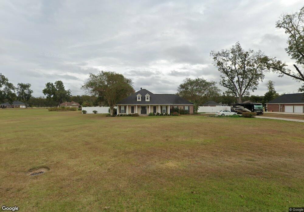
104 Kiowa St Monroe, LA 71203
Estimated Value: $370,204 - $404,000
4
Beds
3
Baths
2,422
Sq Ft
$159/Sq Ft
Est. Value
About This Home
This home is located at 104 Kiowa St, Monroe, LA 71203 and is currently estimated at $385,551, approximately $159 per square foot. 104 Kiowa St is a home located in Ouachita Parish with nearby schools including Swartz Lower Elementary School, Swartz Upper Elementary School, and Ouachita Junior High School.
Ownership History
Date
Name
Owned For
Owner Type
Purchase Details
Closed on
Jul 21, 2021
Sold by
Savage-Cummings Debra and Tiepelman Charles W
Bought by
Ellis Charles E and Lashalle-Ellis Sharonda
Current Estimated Value
Home Financials for this Owner
Home Financials are based on the most recent Mortgage that was taken out on this home.
Original Mortgage
$343,000
Outstanding Balance
$311,693
Interest Rate
3%
Mortgage Type
FHA
Estimated Equity
$73,858
Purchase Details
Closed on
Mar 31, 2005
Sold by
Cartwright Paul Kenneth and Cartwright Kristi Scroggs
Bought by
Cummings Debra Savage and Tiepelman Charles William
Home Financials for this Owner
Home Financials are based on the most recent Mortgage that was taken out on this home.
Original Mortgage
$202,400
Interest Rate
5.78%
Mortgage Type
New Conventional
Create a Home Valuation Report for This Property
The Home Valuation Report is an in-depth analysis detailing your home's value as well as a comparison with similar homes in the area
Home Values in the Area
Average Home Value in this Area
Purchase History
| Date | Buyer | Sale Price | Title Company |
|---|---|---|---|
| Ellis Charles E | $343,000 | None Available | |
| Cummings Debra Savage | $253,000 | None Available |
Source: Public Records
Mortgage History
| Date | Status | Borrower | Loan Amount |
|---|---|---|---|
| Open | Ellis Charles E | $343,000 | |
| Previous Owner | Cummings Debra Savage | $202,400 | |
| Previous Owner | Cummings Debra Savage | $25,000 |
Source: Public Records
Tax History Compared to Growth
Tax History
| Year | Tax Paid | Tax Assessment Tax Assessment Total Assessment is a certain percentage of the fair market value that is determined by local assessors to be the total taxable value of land and additions on the property. | Land | Improvement |
|---|---|---|---|---|
| 2024 | -- | $30,310 | $3,500 | $26,810 |
| 2023 | $3,691 | $25,278 | $3,500 | $21,778 |
| 2022 | $3,665 | $25,278 | $3,500 | $21,778 |
| 2021 | $3,694 | $26,778 | $3,500 | $23,278 |
| 2020 | $3,694 | $26,778 | $3,500 | $23,278 |
| 2019 | $3,440 | $25,283 | $3,500 | $21,783 |
| 2018 | $2,313 | $25,283 | $3,500 | $21,783 |
| 2017 | $3,369 | $25,283 | $3,500 | $21,783 |
| 2016 | $3,287 | $25,283 | $3,500 | $21,783 |
| 2015 | $2,308 | $25,283 | $3,500 | $21,783 |
| 2014 | $2,308 | $25,283 | $3,500 | $21,783 |
| 2013 | $2,303 | $25,283 | $3,500 | $21,783 |
Source: Public Records
Map
Nearby Homes
- 306 Taylor Dr
- 229 Eisenhower Dr
- 209 Harding Dr
- 158 Barbara Dr
- 1870 Highway 594
- 1077 Stubbs Vinson Rd
- 119 Daywood Dr
- 120 Donovan Cir
- 94 Nelson Rd
- 202 Daywood Dr
- 204 W Nelson Rd Unit 412 Allen, 413 n 23r
- 2210 Highway 594
- 212 Wood Dr
- 2238 Highway 594
- 719 Ed Edelen Rd
- 0 Braebend Dr
- 637 Rowland Rd
- 300 Timber Way
- 63 Forest Dr
- 284 Connie Lynne Dr