Estimated Value: $134,000 - $153,000
1
Bed
2
Baths
1,370
Sq Ft
$105/Sq Ft
Est. Value
About This Home
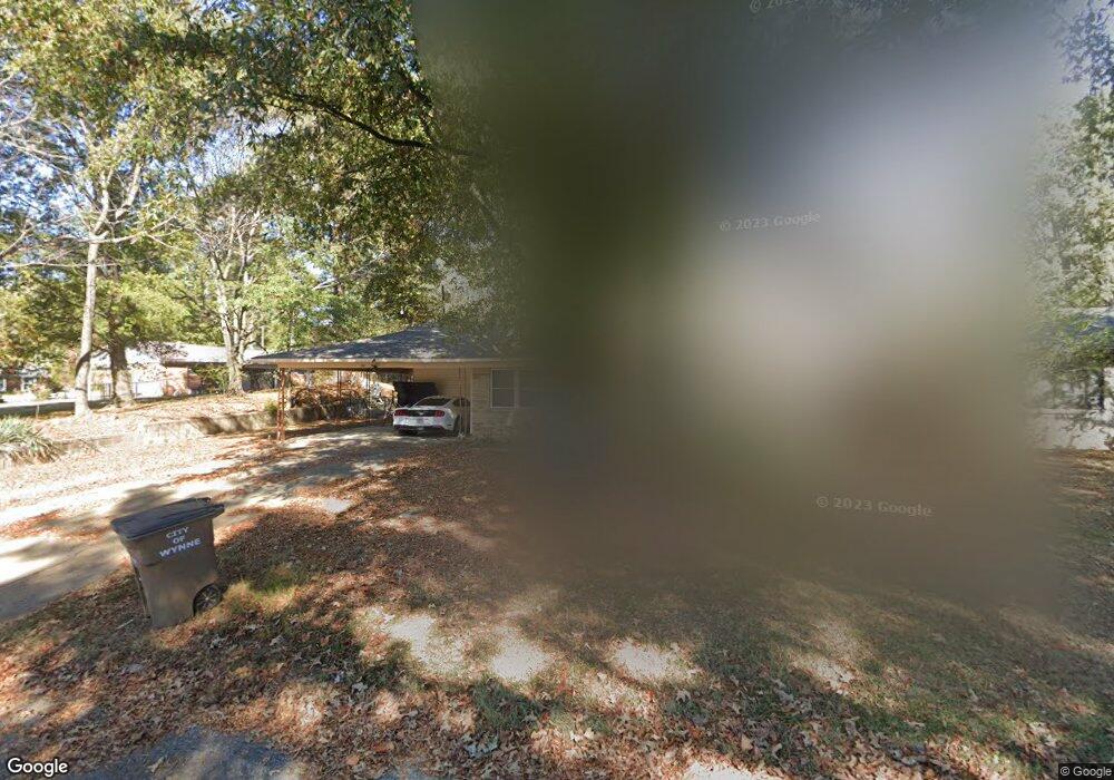
This home is located at 104 Maple Dr, Wynne, AR 72396 and is currently estimated at $144,202, approximately $105 per square foot. 104 Maple Dr is a home located in Cross County with nearby schools including Wynne Intermediate School, Wynne Primary School, and Wynne Junior High School.
Ownership History
Date
Name
Owned For
Owner Type
Purchase Details
Closed on
Mar 31, 2020
Sold by
Holmes Roger L and Holmes Pamela A
Bought by
Holmes Chad and Holmes Coy
Current Estimated Value
Purchase Details
Closed on
Jan 23, 2002
Bought by
Holmes Roger L
Purchase Details
Closed on
Jan 22, 2002
Bought by
Sec. Of Housing & Urban Dev.
Purchase Details
Closed on
Oct 17, 2001
Bought by
Sec. Of Housing & Urban Dev.
Purchase Details
Closed on
Sep 17, 2001
Bought by
Washington Mutual Home Loans,Inc and Attn
Purchase Details
Closed on
Sep 19, 1995
Bought by
Prislovsky John L
Create a Home Valuation Report for This Property
The Home Valuation Report is an in-depth analysis detailing your home's value as well as a comparison with similar homes in the area
Purchase History
| Date | Buyer | Sale Price | Title Company |
|---|---|---|---|
| Holmes Chad | -- | None Available | |
| Holmes Roger L | -- | -- | |
| Sec. Of Housing & Urban Dev. | -- | -- | |
| Sec. Of Housing & Urban Dev. | -- | -- | |
| Washington Mutual Home Loans,Inc | -- | -- | |
| Prislovsky John L | $68,000 | -- |
Source: Public Records
Tax History
| Year | Tax Paid | Tax Assessment Tax Assessment Total Assessment is a certain percentage of the fair market value that is determined by local assessors to be the total taxable value of land and additions on the property. | Land | Improvement |
|---|---|---|---|---|
| 2025 | $989 | $28,220 | $5,230 | $22,990 |
| 2024 | $899 | $18,200 | $4,560 | $13,640 |
| 2023 | $901 | $18,200 | $4,560 | $13,640 |
| 2022 | $901 | $18,200 | $4,560 | $13,640 |
| 2021 | $901 | $18,200 | $4,560 | $13,640 |
| 2020 | $901 | $18,200 | $4,560 | $13,640 |
| 2019 | $819 | $16,540 | $4,120 | $12,420 |
| 2018 | $819 | $16,540 | $4,120 | $12,420 |
| 2017 | $819 | $16,540 | $4,120 | $12,420 |
| 2016 | $819 | $16,540 | $4,120 | $12,420 |
| 2015 | $819 | $16,540 | $4,120 | $12,420 |
| 2014 | $821 | $16,590 | $3,780 | $12,810 |
Source: Public Records
Map
Nearby Homes
- 1621 Dodd Dr
- 129 Lombardy Ln
- 1420 Hamilton Ave E
- 205 Kerry Dr
- 594 Malone St N
- 39 Morningside Dr
- 1104 Hamilton Ave E
- 1321 Martin Dr E
- 1310 Forrest Ave E
- 1106 Marion Dr
- 1204 Forrest Ave E
- 226 Nathan Dr E
- 1011 Hilltop Dr
- 108 Nathan Dr E
- 12 Wynnewood Dr N
- 909 Killough Rd N
- 1406 Airpark Rd
- 1404 Airpark Rd
- 109 Nathan Dr E
- 621 Lemons St N
Your Personal Tour Guide
Ask me questions while you tour the home.