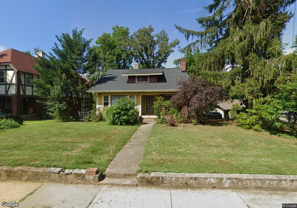
104 Pearson Dr Asheville, NC 28801
Montford NeighborhoodEstimated Value: $418,498 - $504,000
2
Beds
1
Bath
993
Sq Ft
$472/Sq Ft
Est. Value
About This Home
This home is located at 104 Pearson Dr, Asheville, NC 28801 and is currently estimated at $469,125, approximately $472 per square foot. 104 Pearson Dr is a home located in Buncombe County with nearby schools including Isaac Dickson Elementary, Hall Fletcher Elementary, and Ira B Jones Elementary.
Ownership History
Date
Name
Owned For
Owner Type
Purchase Details
Closed on
Oct 2, 2015
Sold by
Mapp Wlater H
Bought by
Perry Sean P
Current Estimated Value
Purchase Details
Closed on
Mar 13, 2003
Sold by
Mauldin Terry L
Bought by
Perry Sean P
Home Financials for this Owner
Home Financials are based on the most recent Mortgage that was taken out on this home.
Original Mortgage
$111,404
Interest Rate
5.88%
Purchase Details
Closed on
Mar 27, 1997
Sold by
Mauldin Terri L
Bought by
Mauldin
Purchase Details
Closed on
Dec 18, 1996
Sold by
Carson Margaret
Bought by
Mauldin
Create a Home Valuation Report for This Property
The Home Valuation Report is an in-depth analysis detailing your home's value as well as a comparison with similar homes in the area
Home Values in the Area
Average Home Value in this Area
Purchase History
| Date | Buyer | Sale Price | Title Company |
|---|---|---|---|
| Perry Sean P | -- | None Available | |
| Perry Sean P | $117,500 | -- | |
| Mauldin | -- | -- | |
| Mauldin | -- | -- |
Source: Public Records
Mortgage History
| Date | Status | Borrower | Loan Amount |
|---|---|---|---|
| Previous Owner | Perry Sean P | $111,404 |
Source: Public Records
Tax History Compared to Growth
Tax History
| Year | Tax Paid | Tax Assessment Tax Assessment Total Assessment is a certain percentage of the fair market value that is determined by local assessors to be the total taxable value of land and additions on the property. | Land | Improvement |
|---|---|---|---|---|
| 2025 | $2,708 | $260,900 | $91,500 | $169,400 |
| 2024 | $2,708 | $260,900 | $91,500 | $169,400 |
| 2023 | $2,708 | $260,900 | $91,500 | $169,400 |
| 2022 | $2,602 | $260,900 | $91,500 | $169,400 |
| 2021 | $2,602 | $260,900 | $0 | $0 |
| 2020 | $2,415 | $224,000 | $0 | $0 |
| 2019 | $2,415 | $224,000 | $0 | $0 |
| 2018 | $2,415 | $224,000 | $0 | $0 |
| 2017 | $2,437 | $168,900 | $0 | $0 |
| 2016 | $2,076 | $168,900 | $0 | $0 |
| 2015 | $2,076 | $168,900 | $0 | $0 |
| 2014 | $2,050 | $168,900 | $0 | $0 |
Source: Public Records
Map
Nearby Homes
- 112 Pearson Dr
- 30 Gray St
- 288 Montford Ave
- 99999 Gray St
- 11 Cullowhee St
- 44 Watauga St
- 57 Rosewood Ave
- 177 Cumberland Ave
- 46 Cumberland Cir
- 162 Courtland Place
- 99999 Blake St
- 67 Westover Dr
- 51, 51B Westover Dr
- 149 Courtland Ave Unit 5
- 100 West St
- 84 Elizabeth St
- 13 North St
- 132 Houston St Unit B
- 63 Cumberland Ave
- 120 Flint St