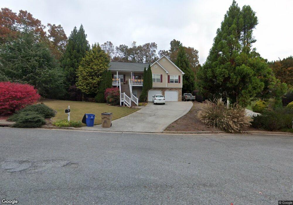
104 Sable Trace Trail Acworth, GA 30102
Oak Grove NeighborhoodEstimated Value: $421,394 - $444,000
3
Beds
2
Baths
2,264
Sq Ft
$191/Sq Ft
Est. Value
About This Home
This home is located at 104 Sable Trace Trail, Acworth, GA 30102 and is currently estimated at $432,697, approximately $191 per square foot. 104 Sable Trace Trail is a home located in Cherokee County with nearby schools including Oak Grove Elementary School, E. T. Booth Middle School, and Etowah High School.
Ownership History
Date
Name
Owned For
Owner Type
Purchase Details
Closed on
May 22, 2024
Sold by
Janco William J
Bought by
Janco William J and Janco Terrie L
Current Estimated Value
Purchase Details
Closed on
Sep 4, 2003
Sold by
Kitchens Honor L
Bought by
Janco William and Janco Terrie
Home Financials for this Owner
Home Financials are based on the most recent Mortgage that was taken out on this home.
Original Mortgage
$179,254
Interest Rate
6.24%
Mortgage Type
VA
Create a Home Valuation Report for This Property
The Home Valuation Report is an in-depth analysis detailing your home's value as well as a comparison with similar homes in the area
Home Values in the Area
Average Home Value in this Area
Purchase History
| Date | Buyer | Sale Price | Title Company |
|---|---|---|---|
| Janco William J | -- | -- | |
| Janco William | $183,000 | -- |
Source: Public Records
Mortgage History
| Date | Status | Borrower | Loan Amount |
|---|---|---|---|
| Previous Owner | Janco William | $179,254 |
Source: Public Records
Tax History
| Year | Tax Paid | Tax Assessment Tax Assessment Total Assessment is a certain percentage of the fair market value that is determined by local assessors to be the total taxable value of land and additions on the property. | Land | Improvement |
|---|---|---|---|---|
| 2025 | $887 | $162,200 | $34,000 | $128,200 |
| 2024 | $863 | $163,080 | $34,000 | $129,080 |
| 2023 | $3,842 | $164,960 | $34,000 | $130,960 |
| 2022 | $3,114 | $130,760 | $32,000 | $98,760 |
| 2021 | $2,813 | $106,600 | $24,000 | $82,600 |
| 2020 | $2,653 | $99,600 | $22,000 | $77,600 |
| 2019 | $2,558 | $95,520 | $22,000 | $73,520 |
| 2018 | $2,345 | $85,840 | $19,200 | $66,640 |
| 2017 | $2,338 | $211,900 | $19,200 | $65,560 |
| 2016 | $2,163 | $191,500 | $19,200 | $57,400 |
| 2015 | $1,941 | $170,800 | $15,200 | $53,120 |
| 2014 | $1,897 | $166,700 | $13,000 | $53,680 |
Source: Public Records
Map
Nearby Homes
- 307 Queensbury Walk
- 304 Queensbury Walk
- 756 Coventry Cove Way
- 752 Coventry Cove Way
- 748 Coventry Cove Way
- 744 Coventry Cove Way
- 740 Coventry Cove Way
- 341 Brighton Bend Ln
- 337 Brighton Bend Ln
- 333 Brighton Bend Ln
- 204 Queensbury Ct
- 6390 Woodstock Rd
- 585 Lee Dr
- 222 Gallant Fox Way
- 105 Discovery Dr
- 301 Buckpasser Ct
- 302 Victory Commons Overlook
- 648 Devon Aly
- 544 Aberdeen Meadow Ln
- 1216 Marlo Way
- 106 Sable Trace Trail
- 102 Sable Trace Trail
- 108 Sable Trace Trail
- 100 Sable Trace Trail
- 105 Sable Trace Trail
- 305 Queensbury Walk
- 101 Sable Trace Tl
- 110 Sable Trace Trail
- 1042 Queensbury Run Unit 2
- 107 Sable Trace Trail
- 101 Sable Trace Trail
- 107 Sable Trace Tl
- 0 Sable Trace Tl
- 103 Sable Trace Trail
- 1040 Queensbury Run Unit 2
- 1044 Queensbury Run
- 303 Queensbury Walk
- 109 Sable Trace Trail
- 1046 Queensbury Run
- 112 Sable Trace Trail