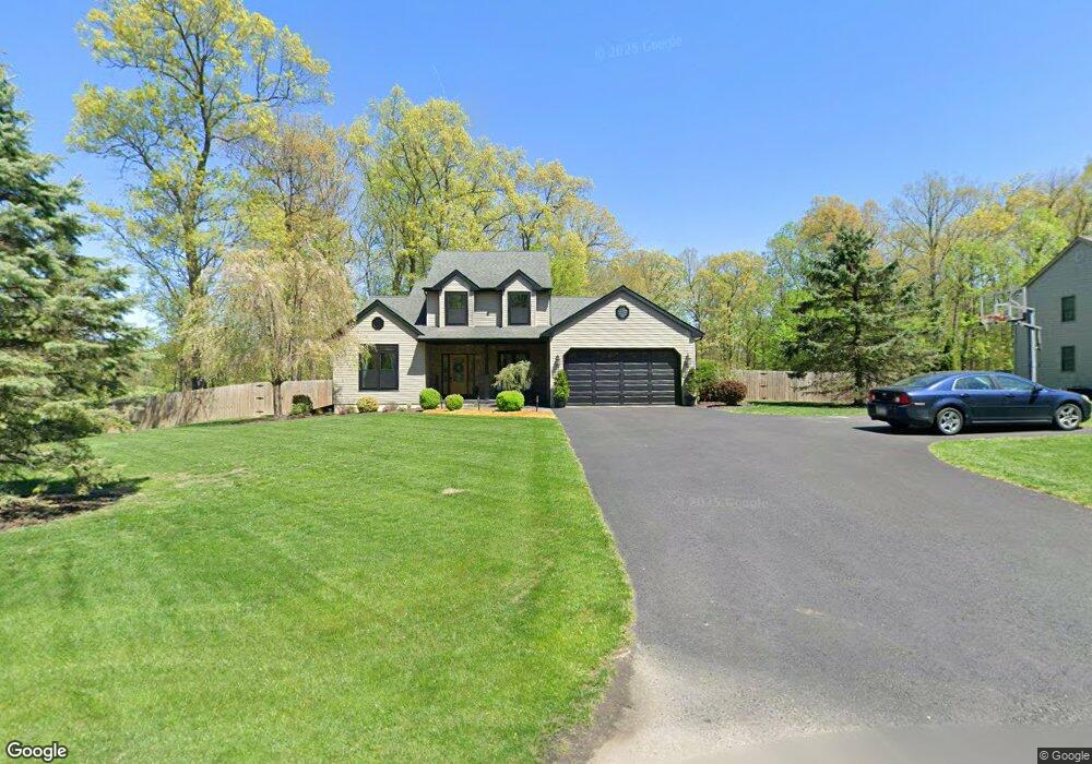
104 Toby Rd Coatesville, PA 19320
Estimated Value: $466,000 - $511,000
4
Beds
3
Baths
2,133
Sq Ft
$232/Sq Ft
Est. Value
About This Home
This home is located at 104 Toby Rd, Coatesville, PA 19320 and is currently estimated at $495,603, approximately $232 per square foot. 104 Toby Rd is a home located in Chester County with nearby schools including Kings Highway Elementary School, Coatesville Intermediate High School, and Coatesville Area Senior High School.
Ownership History
Date
Name
Owned For
Owner Type
Purchase Details
Closed on
Jul 12, 2007
Sold by
Baldwin Robert I and Baldwin Selema A
Bought by
Doan Brett and Doan Erika
Current Estimated Value
Home Financials for this Owner
Home Financials are based on the most recent Mortgage that was taken out on this home.
Original Mortgage
$317,000
Outstanding Balance
$198,549
Interest Rate
6.54%
Mortgage Type
Purchase Money Mortgage
Estimated Equity
$297,054
Create a Home Valuation Report for This Property
The Home Valuation Report is an in-depth analysis detailing your home's value as well as a comparison with similar homes in the area
Home Values in the Area
Average Home Value in this Area
Purchase History
| Date | Buyer | Sale Price | Title Company |
|---|---|---|---|
| Doan Brett | $317,000 | None Available |
Source: Public Records
Mortgage History
| Date | Status | Borrower | Loan Amount |
|---|---|---|---|
| Open | Doan Brett | $317,000 |
Source: Public Records
Tax History Compared to Growth
Tax History
| Year | Tax Paid | Tax Assessment Tax Assessment Total Assessment is a certain percentage of the fair market value that is determined by local assessors to be the total taxable value of land and additions on the property. | Land | Improvement |
|---|---|---|---|---|
| 2025 | $8,107 | $164,210 | $41,100 | $123,110 |
| 2024 | $8,107 | $164,210 | $41,100 | $123,110 |
| 2023 | $7,803 | $164,210 | $41,100 | $123,110 |
| 2022 | $7,429 | $164,210 | $41,100 | $123,110 |
| 2021 | $7,308 | $164,210 | $41,100 | $123,110 |
| 2020 | $7,155 | $164,210 | $41,100 | $123,110 |
| 2019 | $6,917 | $164,210 | $41,100 | $123,110 |
| 2018 | $6,615 | $164,210 | $41,100 | $123,110 |
| 2017 | $6,376 | $164,210 | $41,100 | $123,110 |
| 2016 | $5,246 | $164,210 | $41,100 | $123,110 |
| 2015 | $5,246 | $164,210 | $41,100 | $123,110 |
| 2014 | $5,246 | $164,210 | $41,100 | $123,110 |
Source: Public Records
Map
Nearby Homes
- 115 Durham Dr
- 291 N Sandy Hill Rd
- 216 Michael Rd
- 116 Cambridge Rd
- 113 Sandy Way
- 108 Cambridge Rd
- 109 Brylin Dr
- 180 Lilly Rd
- 221 Creamery Rd
- 127 Beacon Light Rd
- 2200 Beaver Dam Rd
- 14 Blue Spruce Dr
- 471 Ash Rd
- 230 Rock Rd
- 110 Hillbrook Dr
- 240 S Bonsall Rd
- 317 Compass Rd
- 114 Wendy Cir
- 600 Farmland Way
- 14 Frederick Rd
- 102 Toby Rd
- 103 Toby Rd
- 108 Toby Rd
- 101 Toby Rd
- 112 Toby Rd
- 110 Toby Rd
- 135 Baldwin Rd
- 113 Toby Rd
- 151 Cornwall Place
- 153 Cornwall Place
- 4 Cornwall Place
- 149 Cornwall Place
- 114 Toby Rd
- 147 Cornwall Place
- 145 Cornwall Place
- 103 Cornwall Place
- 125 Baldwin Rd
- 116 Toby Rd
- 105 Cornwall Place
- 143 Cornwall Place