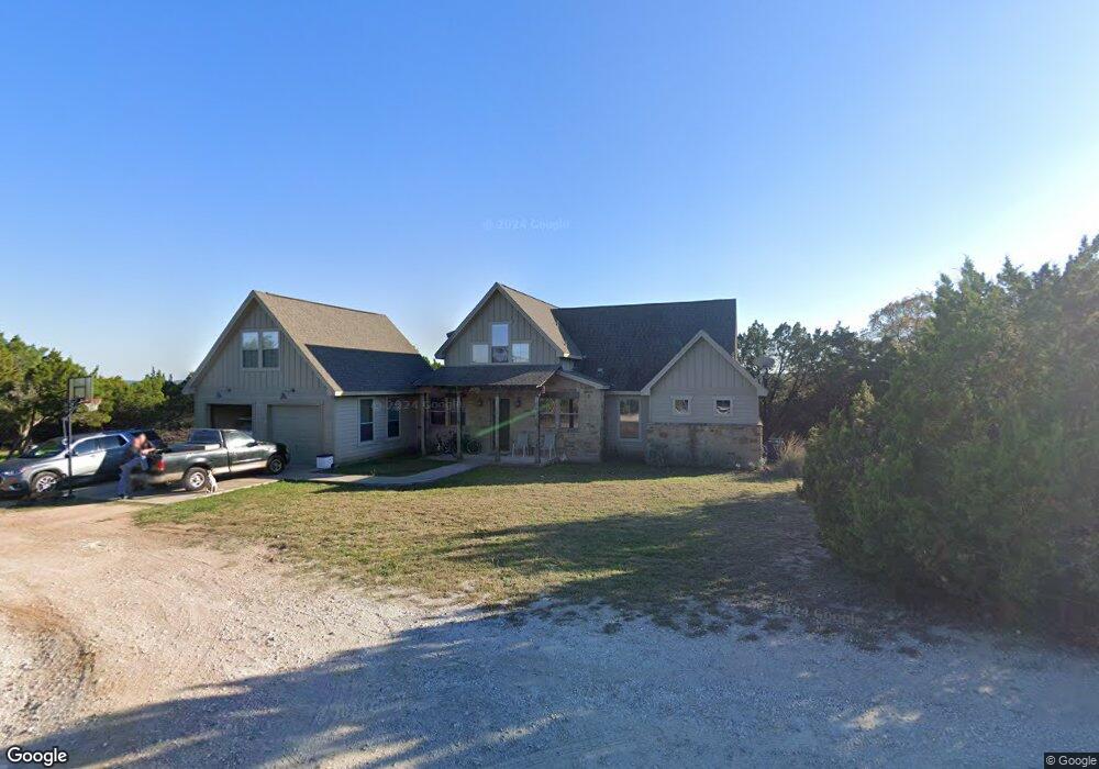
1040 Barrie Dr Unit 2 Austin, TX 78734
Estimated Value: $772,065 - $882,000
4
Beds
3
Baths
2,991
Sq Ft
$276/Sq Ft
Est. Value
About This Home
This home is located at 1040 Barrie Dr Unit 2, Austin, TX 78734 and is currently estimated at $824,766, approximately $275 per square foot. 1040 Barrie Dr Unit 2 is a home located in Travis County with nearby schools including Lakeway Elementary School, Hudson Bend Middle School, and Lake Travis High School.
Ownership History
Date
Name
Owned For
Owner Type
Purchase Details
Closed on
Jan 31, 2007
Sold by
Floyd Robbie N and Breed Pat
Bought by
Taylor Grant C and Taylor Amy
Current Estimated Value
Home Financials for this Owner
Home Financials are based on the most recent Mortgage that was taken out on this home.
Original Mortgage
$320,000
Outstanding Balance
$197,200
Interest Rate
6.11%
Mortgage Type
Purchase Money Mortgage
Estimated Equity
$627,566
Create a Home Valuation Report for This Property
The Home Valuation Report is an in-depth analysis detailing your home's value as well as a comparison with similar homes in the area
Home Values in the Area
Average Home Value in this Area
Purchase History
| Date | Buyer | Sale Price | Title Company |
|---|---|---|---|
| Taylor Grant C | -- | None Available |
Source: Public Records
Mortgage History
| Date | Status | Borrower | Loan Amount |
|---|---|---|---|
| Open | Taylor Grant C | $320,000 |
Source: Public Records
Tax History Compared to Growth
Tax History
| Year | Tax Paid | Tax Assessment Tax Assessment Total Assessment is a certain percentage of the fair market value that is determined by local assessors to be the total taxable value of land and additions on the property. | Land | Improvement |
|---|---|---|---|---|
| 2025 | $14,228 | $717,740 | $473,501 | $244,239 |
| 2023 | $15,402 | $875,171 | $472,500 | $402,671 |
| 2022 | $15,726 | $911,190 | $414,000 | $497,190 |
| 2021 | $12,981 | $608,604 | $165,600 | $443,004 |
| 2020 | $11,119 | $520,369 | $149,040 | $371,329 |
| 2018 | $10,709 | $482,825 | $149,040 | $333,785 |
| 2017 | $9,183 | $413,092 | $77,625 | $335,467 |
| 2016 | $8,511 | $382,865 | $77,625 | $305,240 |
| 2015 | $8,204 | $388,048 | $65,205 | $322,843 |
| 2014 | $8,204 | $353,978 | $65,205 | $288,773 |
Source: Public Records
Map
Nearby Homes
- 1302 Sparrow Ln
- 1155 Barrie Dr
- 1300 Sparrow Ln
- 15102 Warbler Dr
- 1006 Barrie Dr
- 1004 Barrie Dr
- 1002 Barrie Dr
- 15085 Dorothy Dr
- 15087 Dorothy Dr
- Lot 19 Sparrow Ln
- 16 Mountain Terrace Cove
- 15098 Dorothy Dr
- 15105 Mettle Dr
- 15 Stone Terrace Dr
- 1101 Big Bill Ct
- 15200 Dorothy Dr
- 15099 Strader Cir
- 15098 Strader Cir
- 15101 Barrie Dr
- 31 Cypress Knee Ln Unit 93
- 1040 Barrie Dr
- 1030 Barrie Dr
- 15002 Gebron Dr
- 1302(L) Sparrow Ln
- 1109 Warbler Dr
- 1018 Barrie Dr
- 1016 Barrie Dr
- 1315 Sparrow Ln
- 15008 Gebron Dr
- 1102 Warbler Dr
- 1014 Barrie Dr
- 1025000 Barrie Dr
- 15109 Barrie Dr
- TBD Barrie Dr
- 1015 Warbler Dr
- 1012 Barrie Dr
- 15094 Warbler Dr
- 15098 Warbler Dr
- 15096 Warbler Dr
- 1401 Parker Bend