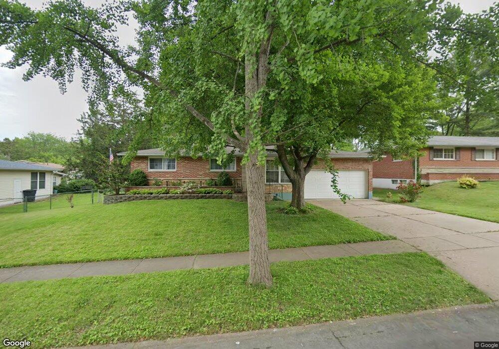
1040 Meadowlark Dr Florissant, MO 63033
Estimated Value: $204,474 - $232,000
3
Beds
2
Baths
1,399
Sq Ft
$155/Sq Ft
Est. Value
About This Home
This home is located at 1040 Meadowlark Dr, Florissant, MO 63033 and is currently estimated at $216,369, approximately $154 per square foot. 1040 Meadowlark Dr is a home located in St. Louis County with nearby schools including Parker Road Elementary School, Cross Keys Middle School, and McCluer North High School.
Ownership History
Date
Name
Owned For
Owner Type
Purchase Details
Closed on
Jul 30, 2007
Sold by
Gibson Marilyn A
Bought by
Kasten Shaun P
Current Estimated Value
Home Financials for this Owner
Home Financials are based on the most recent Mortgage that was taken out on this home.
Original Mortgage
$123,200
Outstanding Balance
$77,924
Interest Rate
6.73%
Mortgage Type
Purchase Money Mortgage
Estimated Equity
$138,445
Purchase Details
Closed on
Jun 25, 2002
Sold by
Valerius Richard C and Valerius Diane S
Bought by
Gibson Marilyn A
Home Financials for this Owner
Home Financials are based on the most recent Mortgage that was taken out on this home.
Original Mortgage
$95,200
Interest Rate
5.87%
Purchase Details
Closed on
Jun 12, 2000
Sold by
Valerius Herbert C
Bought by
Valerius Richard C and Valerius Lawrence H
Create a Home Valuation Report for This Property
The Home Valuation Report is an in-depth analysis detailing your home's value as well as a comparison with similar homes in the area
Home Values in the Area
Average Home Value in this Area
Purchase History
| Date | Buyer | Sale Price | Title Company |
|---|---|---|---|
| Kasten Shaun P | $154,000 | Ort | |
| Gibson Marilyn A | $119,000 | -- | |
| Gibson Marilyn A | $119,000 | -- | |
| Valerius Richard C | -- | -- |
Source: Public Records
Mortgage History
| Date | Status | Borrower | Loan Amount |
|---|---|---|---|
| Open | Kasten Shaun P | $123,200 | |
| Previous Owner | Gibson Marilyn A | $95,200 |
Source: Public Records
Tax History Compared to Growth
Tax History
| Year | Tax Paid | Tax Assessment Tax Assessment Total Assessment is a certain percentage of the fair market value that is determined by local assessors to be the total taxable value of land and additions on the property. | Land | Improvement |
|---|---|---|---|---|
| 2025 | $2,526 | $35,700 | $4,140 | $31,560 |
| 2024 | $2,526 | $32,700 | $2,850 | $29,850 |
| 2023 | $2,517 | $32,700 | $2,850 | $29,850 |
| 2022 | $2,265 | $25,840 | $3,650 | $22,190 |
| 2021 | $2,227 | $25,840 | $3,650 | $22,190 |
| 2020 | $2,071 | $22,570 | $4,140 | $18,430 |
| 2019 | $2,031 | $22,570 | $4,140 | $18,430 |
| 2018 | $1,982 | $19,680 | $2,070 | $17,610 |
| 2017 | $1,972 | $19,680 | $2,070 | $17,610 |
| 2016 | $2,075 | $20,200 | $4,540 | $15,660 |
| 2015 | $2,088 | $20,200 | $4,540 | $15,660 |
| 2014 | $1,987 | $19,840 | $4,200 | $15,640 |
Source: Public Records
Map
Nearby Homes
- 1040 Bluefield Dr
- 1200 Bluefield Dr
- 1980 Parker Rd
- 1090 Saint Joseph St
- 765 Pimlico Dr
- 1290 Saint Louis St
- 1965 Saint Catherine St
- 629 Aubuchon St
- 2425 Johnstown Dr
- 675 Pimlico Dr
- 1023 Saint Denis St
- 1148 Boone St
- 1130 Saint Francois St
- 505 Ridge Dr
- 1420 Nashua Dr
- 865 Boone St
- 2340 Saint Catherine St
- 1060 Preakness Ln
- 1150 Clark St
- 1480 Burning Tree Dr
- 1020 Meadowlark Dr
- 1925 Saint Joseph St
- 1460 Saint Michael St
- 1945 Saint Joseph St
- 1035 Meadowlark Dr
- 1025 Meadowlark Dr
- 1480 Saint Michael St
- 1965 Saint Joseph St
- 1965 St Joseph
- 1065 Meadowlark Dr
- 1910 Saint Joseph St
- 1920 Saint Joseph St
- 1900 Saint Joseph St
- 1485 Saint Michael St
- 1985 Saint Joseph St
- 1840 Saint Joseph St
- 1930 Saint Joseph St
- 1385 Saint Joseph St
- 1390 Saint Michael St
- 1880 Saint Joseph St