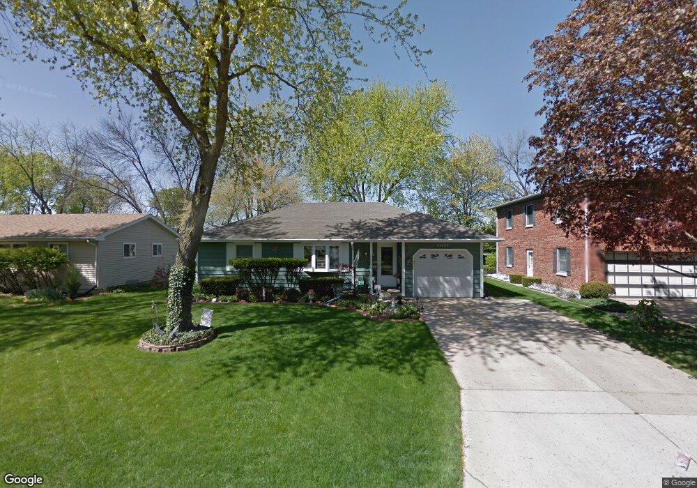
1040 N Elmwood Dr Aurora, IL 60506
North River NeighborhoodEstimated Value: $242,000 - $336,000
3
Beds
1
Bath
1,232
Sq Ft
$231/Sq Ft
Est. Value
About This Home
This home is located at 1040 N Elmwood Dr, Aurora, IL 60506 and is currently estimated at $284,768, approximately $231 per square foot. 1040 N Elmwood Dr is a home located in Kane County with nearby schools including Smith Elementary School, Jewel Middle School, and West Aurora High School.
Ownership History
Date
Name
Owned For
Owner Type
Purchase Details
Closed on
Jul 9, 2025
Sold by
Thomason Stephan B and Thomason Bonnie L
Bought by
Thomason Family Trust and Thomason
Current Estimated Value
Purchase Details
Closed on
Mar 12, 2009
Sold by
Thomason Stephan B
Bought by
Thomason Stephan B and Thomason Bonnie L
Home Financials for this Owner
Home Financials are based on the most recent Mortgage that was taken out on this home.
Original Mortgage
$101,000
Interest Rate
5.11%
Mortgage Type
New Conventional
Purchase Details
Closed on
May 26, 1995
Sold by
Hollarbush Paul A and Hollarbush Brenda K
Bought by
Thomason Stephan B and Thomason Sheryl L
Home Financials for this Owner
Home Financials are based on the most recent Mortgage that was taken out on this home.
Original Mortgage
$107,822
Interest Rate
8.26%
Mortgage Type
FHA
Create a Home Valuation Report for This Property
The Home Valuation Report is an in-depth analysis detailing your home's value as well as a comparison with similar homes in the area
Home Values in the Area
Average Home Value in this Area
Purchase History
| Date | Buyer | Sale Price | Title Company |
|---|---|---|---|
| Thomason Family Trust | -- | None Listed On Document | |
| Thomason Stephan B | -- | Greater Metropolitan Title L | |
| Thomason Stephan B | $111,000 | -- |
Source: Public Records
Mortgage History
| Date | Status | Borrower | Loan Amount |
|---|---|---|---|
| Previous Owner | Thomason Stephan B | $101,000 | |
| Previous Owner | Thomason Stephan B | $107,822 |
Source: Public Records
Tax History Compared to Growth
Tax History
| Year | Tax Paid | Tax Assessment Tax Assessment Total Assessment is a certain percentage of the fair market value that is determined by local assessors to be the total taxable value of land and additions on the property. | Land | Improvement |
|---|---|---|---|---|
| 2024 | $5,071 | $72,047 | $9,711 | $62,336 |
| 2023 | $4,829 | $64,374 | $8,677 | $55,697 |
| 2022 | $4,668 | $58,735 | $7,917 | $50,818 |
| 2021 | $4,448 | $54,683 | $7,371 | $47,312 |
| 2020 | $4,822 | $57,512 | $6,847 | $50,665 |
| 2019 | $4,679 | $53,854 | $6,344 | $47,510 |
| 2018 | $4,315 | $49,227 | $5,868 | $43,359 |
| 2017 | $4,016 | $45,022 | $5,407 | $39,615 |
| 2016 | $3,841 | $42,159 | $4,635 | $37,524 |
| 2015 | -- | $36,756 | $3,986 | $32,770 |
| 2014 | -- | $34,054 | $3,663 | $30,391 |
| 2013 | -- | $37,002 | $3,714 | $33,288 |
Source: Public Records
Map
Nearby Homes
- 1296 Yellowpine Dr
- 795 N Elmwood Dr
- 781 N Elmwood Dr
- 1199 Pin Oak Trail
- 1532 Golden Oaks Pkwy
- 1104 New Haven Ave
- 1351 Monomoy St Unit D
- 1389 Monomoy St Unit B2
- 833 N Randall Rd Unit C4
- 1035 Newcastle Ln
- 972 Westgate Dr
- 616 Morton Ave
- 461 Sullivan Rd
- 967 Sapphire Ln
- 959 Sapphire Ln
- 963 Sapphire Ln
- 943 Charles St
- 960 Sapphire Ln
- 964 Sapphire Ln
- 376 Florida Ave
- 1050 N Elmwood Dr
- 1030 N Elmwood Dr
- 1060 N Elmwood Dr
- 1020 N Elmwood Dr
- 1080 N Elmwood Dr
- 1010 N Elmwood Dr
- 1051 N Elmwood Dr
- 1031 N Elmwood Dr
- 1100 N Elmwood Dr
- 1061 N Elmwood Dr
- 1021 N Elmwood Dr
- 1006 N Elmwood Dr
- 1081 N Elmwood Dr
- 1100 Flint Ct
- 1120 N Elmwood Dr
- 1011 N Elmwood Dr
- 1101 N Elmwood Dr
- 1110 Flint Ct
- 1000 N Elmwood Dr
- 1007 N Elmwood Dr