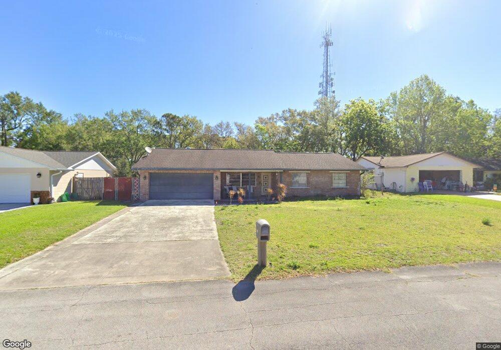
1040 Wexford Way Port Orange, FL 32129
Port Orange West NeighborhoodEstimated Value: $283,140 - $321,000
3
Beds
2
Baths
1,447
Sq Ft
$211/Sq Ft
Est. Value
About This Home
This home is located at 1040 Wexford Way, Port Orange, FL 32129 and is currently estimated at $305,785, approximately $211 per square foot. 1040 Wexford Way is a home located in Volusia County with nearby schools including Atlantic High School, Sugar Mill Elementary School, and Silver Sands Middle School.
Ownership History
Date
Name
Owned For
Owner Type
Purchase Details
Closed on
May 29, 2025
Sold by
Newingham Roderick P
Bought by
Newingham Bobbi Jean
Current Estimated Value
Purchase Details
Closed on
May 8, 2013
Sold by
Newingham Richard Allen
Bought by
Newingham Roderick Paul
Purchase Details
Closed on
Aug 7, 1998
Sold by
Koch Joseph H
Bought by
Newingham Richard and Newingham Jane
Purchase Details
Closed on
Apr 15, 1981
Bought by
Newingham Roderick Paul
Create a Home Valuation Report for This Property
The Home Valuation Report is an in-depth analysis detailing your home's value as well as a comparison with similar homes in the area
Home Values in the Area
Average Home Value in this Area
Purchase History
| Date | Buyer | Sale Price | Title Company |
|---|---|---|---|
| Newingham Bobbi Jean | $100 | None Listed On Document | |
| Newingham Roderick Paul | -- | None Available | |
| Newingham Richard | -- | -- | |
| Newingham Richard | $92,000 | -- | |
| Newingham Roderick Paul | $54,900 | -- |
Source: Public Records
Tax History Compared to Growth
Tax History
| Year | Tax Paid | Tax Assessment Tax Assessment Total Assessment is a certain percentage of the fair market value that is determined by local assessors to be the total taxable value of land and additions on the property. | Land | Improvement |
|---|---|---|---|---|
| 2025 | $3,622 | $228,810 | $75,200 | $153,610 |
| 2024 | $3,622 | $232,422 | $75,200 | $157,222 |
| 2023 | $3,622 | $211,451 | $70,000 | $141,451 |
| 2022 | $3,324 | $195,143 | $38,800 | $156,343 |
| 2021 | $3,113 | $160,323 | $26,800 | $133,523 |
| 2020 | $3,089 | $160,847 | $26,000 | $134,847 |
| 2019 | $2,887 | $151,255 | $20,800 | $130,455 |
| 2018 | $1,562 | $118,733 | $0 | $0 |
| 2017 | $1,560 | $116,291 | $0 | $0 |
| 2016 | $1,552 | $113,899 | $0 | $0 |
| 2015 | $1,596 | $113,107 | $0 | $0 |
| 2014 | $2,497 | $113,316 | $0 | $0 |
Source: Public Records
Map
Nearby Homes
- 4041 S Waterbridge Cir
- 4039 N Waterbridge Cir
- 1077 Willow Wood Dr
- 993 Appleview Way
- 1086 Donnell Dr
- 4029 N Waterbridge Cir
- 1300 Harms Way
- 1075 Horizon View Blvd
- 803 Black Duck Dr
- 3929 Oak Crest Cir
- 800 Black Duck Dr
- 4015 N Waterbridge Cir
- 5912 Plainview Dr
- 1118 Kane Dr
- 3916 Oak Crest Cir
- 1132 Loblolly Ln
- 937 Meadow View Dr Unit D
- 1106 Blueberry Dr
- 930 Chickadee Dr
- 955 Grayling Ct Unit B
- 1038 Wexford Way
- 1042 Wexford Way
- 1036 Wexford Way
- 1060 York Way
- 1047 Wexford Way
- 1044 Wexford Way
- 1034 Wexford Way
- 1062 York Way
- 1053 Wexford Way
- 1048 Wexford Way
- 1061 York Way
- 1 Kimberly Ct
- 1032 Wexford Way
- 1064 York Way
- 1050 Wexford Way
- 1055 Wexford Way
- 1063 York Way
- 1064 Kimberly Ct
- 1045 Azalea Pointe Dr
- 1052 Wexford Way