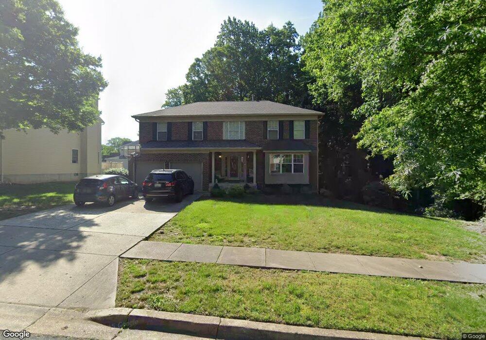
10402 Wrensong Ln Clinton, MD 20735
Estimated Value: $582,769 - $631,000
--
Bed
3
Baths
2,590
Sq Ft
$233/Sq Ft
Est. Value
About This Home
This home is located at 10402 Wrensong Ln, Clinton, MD 20735 and is currently estimated at $602,942, approximately $232 per square foot. 10402 Wrensong Ln is a home located in Prince George's County with nearby schools including Waldon Woods Elementary School, Stephen Decatur Middle School, and Surrattsville High School.
Ownership History
Date
Name
Owned For
Owner Type
Purchase Details
Closed on
Oct 3, 2001
Sold by
Clark Alvin
Bought by
Brown Tanya L
Current Estimated Value
Purchase Details
Closed on
Nov 13, 1998
Sold by
Walls Sandra K
Bought by
Clark Alvin and Clark Veda
Purchase Details
Closed on
Nov 22, 1994
Sold by
Lovell Regency Homes Lp
Bought by
Walls Sandra K
Home Financials for this Owner
Home Financials are based on the most recent Mortgage that was taken out on this home.
Original Mortgage
$226,750
Interest Rate
8.9%
Create a Home Valuation Report for This Property
The Home Valuation Report is an in-depth analysis detailing your home's value as well as a comparison with similar homes in the area
Home Values in the Area
Average Home Value in this Area
Purchase History
| Date | Buyer | Sale Price | Title Company |
|---|---|---|---|
| Brown Tanya L | $230,000 | -- | |
| Clark Alvin | $243,235 | -- | |
| Walls Sandra K | $238,735 | -- |
Source: Public Records
Mortgage History
| Date | Status | Borrower | Loan Amount |
|---|---|---|---|
| Previous Owner | Walls Sandra K | $226,750 |
Source: Public Records
Tax History Compared to Growth
Tax History
| Year | Tax Paid | Tax Assessment Tax Assessment Total Assessment is a certain percentage of the fair market value that is determined by local assessors to be the total taxable value of land and additions on the property. | Land | Improvement |
|---|---|---|---|---|
| 2025 | $7,729 | $535,300 | $126,200 | $409,100 |
| 2024 | $7,729 | $493,300 | $0 | $0 |
| 2023 | $5,018 | $451,300 | $0 | $0 |
| 2022 | $6,480 | $409,300 | $101,200 | $308,100 |
| 2021 | $6,309 | $397,800 | $0 | $0 |
| 2020 | $6,138 | $386,300 | $0 | $0 |
| 2019 | $5,967 | $374,800 | $100,600 | $274,200 |
| 2018 | $6,362 | $351,933 | $0 | $0 |
| 2017 | $6,022 | $329,067 | $0 | $0 |
| 2016 | -- | $306,200 | $0 | $0 |
| 2015 | $5,221 | $300,567 | $0 | $0 |
| 2014 | $5,221 | $294,933 | $0 | $0 |
Source: Public Records
Map
Nearby Homes
- 10203 Deep Creek Ct
- 7006 Chain Fern Ct
- 7001 Killarney St
- 10309 Brandywine Rd
- 9917 Raintree Way
- 10802 Slippery Elm Ct
- 6204 Armor Dr
- Cedar Pointe Unit 8 MOVE IN FOR 0
- Cedar Pointe
- 7300 Roxy Run Unit 6
- 7304 Roxy Run Unit 8
- 7308 Roxy Run Unit 10
- Kennedy Plan at Cedar Pointe
- 10306 Serenade Ct
- 7300 Jill View Way Unit 22
- 5904 Spell Rd
- 8403 Black Willow Ct
- 6100 Hellen Lee Dr
- 9605 Beverly Ave
- 9923 Quiet Brook Ln
- 10400 Wrensong Ln
- 10306 Mount Auburn Dr
- 10403 Wrensong Ln
- 10401 Wrensong Ln
- 10304 Mount Auburn Dr
- 10404 Wrensong Ln
- 10410 Wrensong Ln
- 10307 Mount Auburn Dr
- 10300 Wooden Bridge Ln
- 10309 Mount Auburn Dr
- 10302 Wooden Bridge Ln
- 10305 Mount Auburn Dr
- 10302 Mount Auburn Dr
- 10206 Wooden Bridge Ln
- 10412 Wrensong Ln
- 10303 Mount Auburn Dr
- 10411 Wrensong Ln
- 10204 Wooden Bridge Ln
- 6700 Killarney St
- 10413 Wrensong Ln