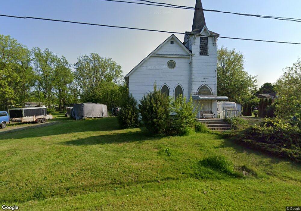
10408 W Mount Morris Rd Flushing, MI 48433
Estimated Value: $142,395 - $180,000
--
Bed
--
Bath
1,064
Sq Ft
$154/Sq Ft
Est. Value
About This Home
This home is located at 10408 W Mount Morris Rd, Flushing, MI 48433 and is currently estimated at $163,849, approximately $153 per square foot. 10408 W Mount Morris Rd is a home located in Genesee County with nearby schools including Elms Elementary School, Flushing Middle School, and Flushing High School.
Ownership History
Date
Name
Owned For
Owner Type
Purchase Details
Closed on
Nov 5, 2019
Sold by
Laponsey Kenneth D and Laponsey Rosalie K
Bought by
Lpaponsey Kenneth D and Lpaponsey Rosalie L
Current Estimated Value
Purchase Details
Closed on
Mar 11, 1999
Sold by
Delaware Street Church Of Christ
Bought by
Laponsey Kenneth D and Laponsey Rosalie K
Purchase Details
Closed on
Jul 25, 1994
Sold by
The Flint Board Of Missions & Church Ext
Bought by
Delaware Street Church Of Christ
Create a Home Valuation Report for This Property
The Home Valuation Report is an in-depth analysis detailing your home's value as well as a comparison with similar homes in the area
Home Values in the Area
Average Home Value in this Area
Purchase History
| Date | Buyer | Sale Price | Title Company |
|---|---|---|---|
| Lpaponsey Kenneth D | -- | None Available | |
| Laponsey Kenneth D | $60,000 | Metropolitan Title Company | |
| Delaware Street Church Of Christ | $40,000 | Centennial Title & Abstract |
Source: Public Records
Tax History Compared to Growth
Tax History
| Year | Tax Paid | Tax Assessment Tax Assessment Total Assessment is a certain percentage of the fair market value that is determined by local assessors to be the total taxable value of land and additions on the property. | Land | Improvement |
|---|---|---|---|---|
| 2025 | $2,211 | $69,400 | $0 | $0 |
| 2024 | $1,468 | $66,600 | $0 | $0 |
| 2023 | $1,399 | $58,500 | $0 | $0 |
| 2022 | $1,968 | $51,700 | $0 | $0 |
| 2021 | $1,934 | $48,500 | $0 | $0 |
| 2020 | $1,278 | $45,800 | $0 | $0 |
| 2019 | $1,266 | $42,300 | $0 | $0 |
| 2018 | $1,811 | $37,600 | $0 | $0 |
| 2017 | $1,161 | $37,600 | $0 | $0 |
| 2016 | $1,698 | $36,100 | $0 | $0 |
| 2015 | $1,554 | $33,500 | $0 | $0 |
| 2014 | $1,136 | $31,800 | $0 | $0 |
| 2012 | -- | $30,800 | $30,800 | $0 |
Source: Public Records
Map
Nearby Homes
- 8073 Nichols Rd
- 7200 N Seymour Rd
- 11186 W Stanley Rd
- 255 Grissom Ct
- 29 Armstrong Ave
- 257 Grissom Ct
- 104 Sheppard Ave Unit 104
- 8498 Duffield Rd
- 8506 Duffield Rd
- 142 Apollo Ave Unit 142
- 196 Apollo Ave
- 8425 Duffield Rd
- 10028 Mcafee Rd
- VL W Frances Rd
- 180 Apollo Cir Unit 180
- 10195 Dodge Rd
- 10187 Dodge Rd
- 9366 Mcafee Rd
- 9222 N Mckinley Rd
- 12374 Stanley Rd
- 10422 W Mount Morris Rd
- 10390 W Mount Morris Rd
- 8021 Dunham St
- 10430 Mt Morris Rd
- 10401 W Mount Morris Rd
- 8027 Dunham St
- 10413 W Mount Morris Rd
- 8022 Dunham St
- 8039 Dunham St
- 10377 W Mount Morris Rd
- 8038 Dunham St
- 10442 W Mount Morris Rd
- 10350 W Mount Morris Rd
- 10344 W Mount Morris Rd
- 10467 W Mount Morris Rd
- 10338 W Mount Morris Rd
- 10338 W Mt Morris
- 10480 W Mount Morris Rd
- 10481 W Mount Morris Rd
- 10486 W Mount Morris Rd