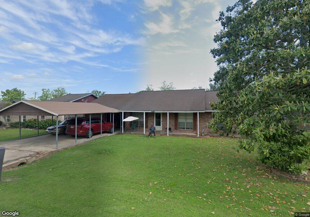
1041 County Road 769 Brazoria, TX 77422
Estimated Value: $207,794 - $246,000
--
Bed
2
Baths
1,584
Sq Ft
$145/Sq Ft
Est. Value
About This Home
This home is located at 1041 County Road 769, Brazoria, TX 77422 and is currently estimated at $229,699, approximately $145 per square foot. 1041 County Road 769 is a home located in Brazoria County.
Ownership History
Date
Name
Owned For
Owner Type
Purchase Details
Closed on
Sep 26, 2012
Sold by
Bates Frank and Bates Iretha W
Bought by
Bates Fraunk and Bates Iretha W
Current Estimated Value
Home Financials for this Owner
Home Financials are based on the most recent Mortgage that was taken out on this home.
Original Mortgage
$166,500
Outstanding Balance
$115,838
Interest Rate
3.61%
Mortgage Type
Reverse Mortgage Home Equity Conversion Mortgage
Estimated Equity
$113,861
Purchase Details
Closed on
Jun 11, 2003
Sold by
Wade Iretha and Bates Iretha
Bought by
Bates Keith D
Purchase Details
Closed on
Apr 3, 2000
Sold by
Davenport Leonard G and Davenport Robbie
Bought by
Bates Frank and Bates Iretha W
Home Financials for this Owner
Home Financials are based on the most recent Mortgage that was taken out on this home.
Original Mortgage
$45,000
Interest Rate
8.37%
Purchase Details
Closed on
Mar 12, 1997
Sold by
Payne Donald W and Payne Deborah A
Bought by
Meador Clayton and Meador Peggy
Create a Home Valuation Report for This Property
The Home Valuation Report is an in-depth analysis detailing your home's value as well as a comparison with similar homes in the area
Home Values in the Area
Average Home Value in this Area
Purchase History
| Date | Buyer | Sale Price | Title Company |
|---|---|---|---|
| Bates Fraunk | -- | None Available | |
| Bates Keith D | -- | -- | |
| Bates Frank | -- | -- | |
| Meador Clayton | -- | -- |
Source: Public Records
Mortgage History
| Date | Status | Borrower | Loan Amount |
|---|---|---|---|
| Open | Bates Fraunk | $166,500 | |
| Previous Owner | Bates Frank | $45,000 |
Source: Public Records
Tax History Compared to Growth
Tax History
| Year | Tax Paid | Tax Assessment Tax Assessment Total Assessment is a certain percentage of the fair market value that is determined by local assessors to be the total taxable value of land and additions on the property. | Land | Improvement |
|---|---|---|---|---|
| 2025 | $514 | $221,630 | $18,470 | $203,160 |
| 2023 | $514 | $197,208 | $18,470 | $205,660 |
| 2022 | $2,830 | $179,280 | $17,780 | $161,500 |
| 2021 | $2,948 | $175,860 | $17,780 | $158,080 |
| 2020 | $3,128 | $178,030 | $17,780 | $160,250 |
| 2019 | $2,903 | $167,410 | $17,780 | $149,630 |
| 2018 | $2,660 | $153,970 | $17,780 | $136,190 |
| 2017 | $2,443 | $140,030 | $17,780 | $122,250 |
| 2016 | $2,221 | $140,030 | $17,780 | $122,250 |
| 2015 | $328 | $122,700 | $13,680 | $109,020 |
| 2014 | $328 | $95,260 | $13,680 | $81,580 |
Source: Public Records
Map
Nearby Homes
- 2560 Cr-769c
- 2541 Cr 769c
- 2082 Fm 521 Rd
- 1561 County Road 797
- 1970 Fm 521 Rd
- 3006 Fm 521 Rd
- 0 County Road 520 Unit 11272899
- 133 Country Oaks St
- 3559 Farm To Market Road 521
- 2719 County Road 510
- 523 Lazy Ln
- 108 Country Oaks St
- 105 Country Oaks St
- 229 Yaupon Dr
- 307 Avenue G
- 323 County Rd 461b
- 0 Pecan Dr
- 232 Magnolia St
- 1208 S Brooks St
- 20331 County Road 510v
- 1033 County Road 769
- 1033 County Road 769
- 1049 County Road 769
- 1061 County Road 769
- 1061 County Road 769
- 1027 County Road 769
- 1027 Cr 769
- 1046 County Road 769
- 1046 County Road 769
- 1046 Cr 769
- 1040 County Road 769
- 1032 County Road 769
- 1032 County Road 769
- 1115 Cr 769
- 1115 County Road 769
- 1019 County Road 769
- 1032 Cr 769 (114 Royal Ridge)
- 1026 County Road 769
- 2426 County Road 769a
- 1014 County Road 769