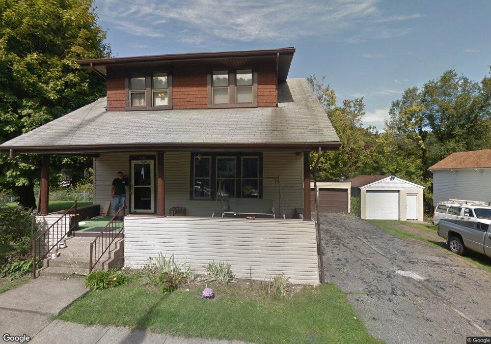
1042 Howard St Bridgeport, OH 43912
Estimated Value: $102,000 - $123,000
3
Beds
1
Bath
1,474
Sq Ft
$76/Sq Ft
Est. Value
About This Home
This home is located at 1042 Howard St, Bridgeport, OH 43912 and is currently estimated at $112,385, approximately $76 per square foot. 1042 Howard St is a home located in Belmont County with nearby schools including Bridgeport Elementary School, Bridgeport Middle School, and Bridgeport High School.
Ownership History
Date
Name
Owned For
Owner Type
Purchase Details
Closed on
Aug 24, 2016
Sold by
Whitacre John F and Whitacre Kathy L
Bought by
Whitacre Jeffrey Thomas
Current Estimated Value
Purchase Details
Closed on
Oct 31, 1997
Sold by
Whitacre John F and Whitacre Kath
Bought by
Whitacre John F and Surv Kathy L
Purchase Details
Closed on
Jan 1, 1986
Sold by
Caruth Nellie E
Bought by
Caruth Nellie E
Create a Home Valuation Report for This Property
The Home Valuation Report is an in-depth analysis detailing your home's value as well as a comparison with similar homes in the area
Home Values in the Area
Average Home Value in this Area
Purchase History
| Date | Buyer | Sale Price | Title Company |
|---|---|---|---|
| Whitacre Jeffrey Thomas | -- | Attorney | |
| Whitacre John F | $55,000 | -- | |
| Caruth Nellie E | -- | -- |
Source: Public Records
Tax History Compared to Growth
Tax History
| Year | Tax Paid | Tax Assessment Tax Assessment Total Assessment is a certain percentage of the fair market value that is determined by local assessors to be the total taxable value of land and additions on the property. | Land | Improvement |
|---|---|---|---|---|
| 2024 | $1,444 | $35,580 | $2,660 | $32,920 |
| 2023 | $968 | $21,230 | $2,670 | $18,560 |
| 2022 | $918 | $21,230 | $2,670 | $18,560 |
| 2021 | $914 | $21,234 | $2,670 | $18,564 |
| 2020 | $746 | $17,700 | $2,230 | $15,470 |
| 2019 | $786 | $17,700 | $2,230 | $15,470 |
| 2018 | $847 | $17,700 | $2,230 | $15,470 |
| 2017 | $929 | $19,980 | $2,630 | $17,350 |
| 2016 | $933 | $19,980 | $2,630 | $17,350 |
| 2015 | $929 | $19,980 | $2,630 | $17,350 |
| 2014 | $802 | $16,610 | $2,390 | $14,220 |
| 2013 | $737 | $16,610 | $2,390 | $14,220 |
Source: Public Records
Map
Nearby Homes
- 1049 Buckeye St
- 866 Main St
- 20 Locust Ave
- 902 National Rd
- 67478 Kirkwood Heights Rd
- 8 Spring St
- 16 Patterson Rd
- 56624 Boyd Ave
- 56316 National Rd
- 56559 Boyd Ave
- 67605 Kirkwood Heights Rd
- 67620 Kirkwood Heights Rd
- 67730 Kirkwood Heights Rd
- 61 Laipple St
- 0 Ohio 7
- 116 Ohio St
- 219 S York St
- 217 N Huron St
- 50 Kentucky St
- 301 N Huron St
- 1046 Howard St
- 1048 Howard St
- 1036 Howard St
- 1045 Howard St
- 1047 Howard St
- 1043 Howard St
- 1034 Howard St
- 1049 Howard St
- 1102 Howard St
- 1037 Howard St
- 1037 Howard St
- 1104 Howard St
- 1033 Howard St
- 1103 Howard St
- 1105 Howard St
- 1108 Howard St
- 1028B Howard St
- 1044 Minellen Dr
- 1040 Minellen Dr
- 3 Cedar St