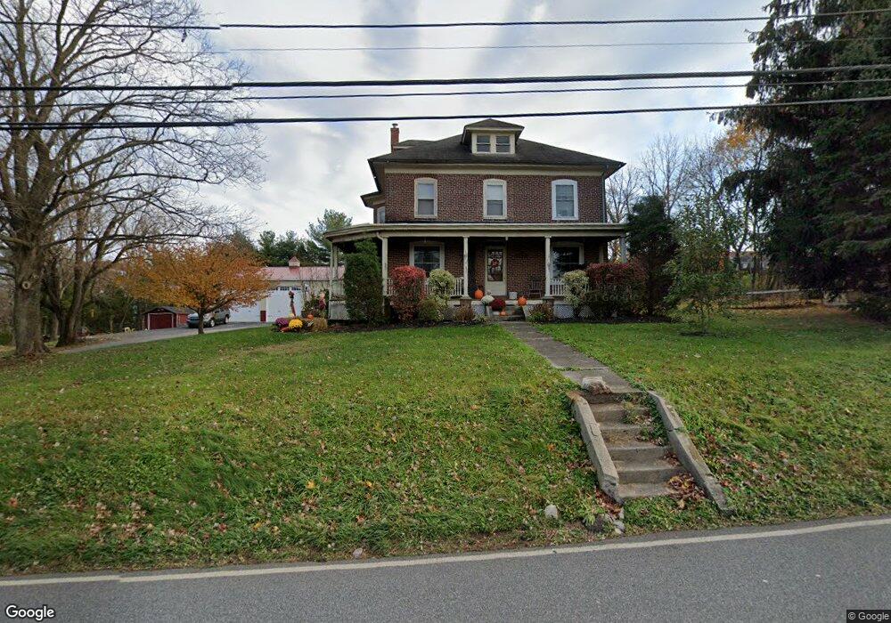
1043 Main St Linfield, PA 19468
Limerick Township NeighborhoodEstimated Value: $352,000 - $550,000
4
Beds
1
Bath
2,184
Sq Ft
$199/Sq Ft
Est. Value
About This Home
This home is located at 1043 Main St, Linfield, PA 19468 and is currently estimated at $435,013, approximately $199 per square foot. 1043 Main St is a home located in Montgomery County with nearby schools including Brooke Elementary School, Spring-Ford Middle School 8th Grade Center, and Spring-Ford Middle School 5/6/7 Grade Center.
Ownership History
Date
Name
Owned For
Owner Type
Purchase Details
Closed on
Jul 10, 2008
Sold by
Deevy Daria C and Deevy John M
Bought by
Osborne Eric M
Current Estimated Value
Home Financials for this Owner
Home Financials are based on the most recent Mortgage that was taken out on this home.
Original Mortgage
$171,000
Outstanding Balance
$111,873
Interest Rate
6.35%
Estimated Equity
$323,140
Purchase Details
Closed on
May 16, 2008
Sold by
Balchunas Walter C and Deevy John J
Bought by
Deevy John M
Home Financials for this Owner
Home Financials are based on the most recent Mortgage that was taken out on this home.
Original Mortgage
$171,000
Outstanding Balance
$111,873
Interest Rate
6.35%
Estimated Equity
$323,140
Create a Home Valuation Report for This Property
The Home Valuation Report is an in-depth analysis detailing your home's value as well as a comparison with similar homes in the area
Home Values in the Area
Average Home Value in this Area
Purchase History
| Date | Buyer | Sale Price | Title Company |
|---|---|---|---|
| Osborne Eric M | $180,000 | None Available | |
| Deevy John M | -- | None Available |
Source: Public Records
Mortgage History
| Date | Status | Borrower | Loan Amount |
|---|---|---|---|
| Open | Osborne Eric M | $171,000 |
Source: Public Records
Tax History Compared to Growth
Tax History
| Year | Tax Paid | Tax Assessment Tax Assessment Total Assessment is a certain percentage of the fair market value that is determined by local assessors to be the total taxable value of land and additions on the property. | Land | Improvement |
|---|---|---|---|---|
| 2025 | $5,055 | $130,710 | $39,060 | $91,650 |
| 2024 | $5,055 | $130,710 | $39,060 | $91,650 |
| 2023 | $4,822 | $130,710 | $39,060 | $91,650 |
| 2022 | $4,659 | $130,710 | $39,060 | $91,650 |
| 2021 | $4,549 | $130,710 | $39,060 | $91,650 |
| 2020 | $4,434 | $130,710 | $39,060 | $91,650 |
| 2019 | $4,353 | $130,710 | $39,060 | $91,650 |
| 2018 | $3,309 | $130,710 | $39,060 | $91,650 |
| 2017 | $4,272 | $130,710 | $39,060 | $91,650 |
| 2016 | $4,221 | $130,710 | $39,060 | $91,650 |
| 2015 | $4,039 | $130,710 | $39,060 | $91,650 |
| 2014 | $4,039 | $130,710 | $39,060 | $91,650 |
Source: Public Records
Map
Nearby Homes
- 75 Gristmill Ln
- 34 Mill Ln
- 2004 Drake Run
- 4 Boraten Rd
- 523 W Linfield Rd
- 523 Linfield Rd #Carlton Grand
- The Carlton Plan at Alderwood Run
- The Sutton Grand Plan at Alderwood Run
- The Sutton Plan at Alderwood Run
- The Carlton Grand Plan at Alderwood Run
- 511 Linfield Rd
- 33 Boraten Rd
- 60 Brownback Rd
- 358 Limerick Center Rd
- 17 Lightcap Rd
- 691 N Lewis Rd
- 25 Walters Ln
- 135 Winged Foot Ct
- 420 N Lewis Rd
- 111 Merion Dr
- 1301 Red Rock Cir
- 1303 Red Rock Cir
- 1305 Red Rock Cir
- 1307 Red Rock Cir
- 1309 Red Rock Cir
- 1048 Main St
- 1210 Red Rock Cir
- 1212 Red Rock Cir
- 1206 Red Rock Cir
- 1311 Red Rock Cir
- 1204 Red Rock Cir
- 1402 Red Rock Cir
- 1202 Red Rock Cir
- 1406 Red Rock Cir
- 1109 Red Rock Cir
- 1408 Red Rock Cir
- 1107 Red Rock Cir
- 1410 Red Rock Cir
- 1105 Red Rock Cir
- 1412 Red Rock Cir