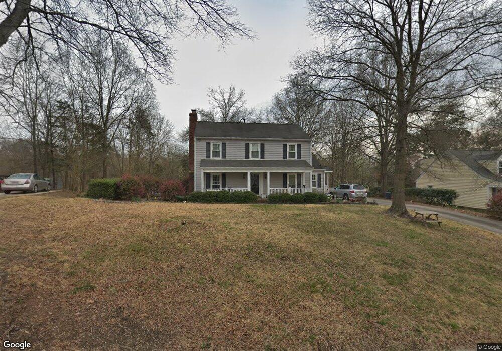
1043 Thornsby Ln Matthews, NC 28105
Estimated Value: $468,603 - $556,000
3
Beds
3
Baths
1,813
Sq Ft
$282/Sq Ft
Est. Value
About This Home
This home is located at 1043 Thornsby Ln, Matthews, NC 28105 and is currently estimated at $511,901, approximately $282 per square foot. 1043 Thornsby Ln is a home located in Mecklenburg County with nearby schools including Elizabeth Lane Elementary, South Charlotte Middle, and Providence High.
Ownership History
Date
Name
Owned For
Owner Type
Purchase Details
Closed on
Jul 28, 2009
Sold by
Smith Carl Leon and Smith Judith M
Bought by
Kuncoro Markus Wahyu and Riany Firsta
Current Estimated Value
Home Financials for this Owner
Home Financials are based on the most recent Mortgage that was taken out on this home.
Original Mortgage
$184,000
Outstanding Balance
$120,944
Interest Rate
5.37%
Mortgage Type
Purchase Money Mortgage
Estimated Equity
$390,957
Create a Home Valuation Report for This Property
The Home Valuation Report is an in-depth analysis detailing your home's value as well as a comparison with similar homes in the area
Home Values in the Area
Average Home Value in this Area
Purchase History
| Date | Buyer | Sale Price | Title Company |
|---|---|---|---|
| Kuncoro Markus Wahyu | $230,000 | None Available |
Source: Public Records
Mortgage History
| Date | Status | Borrower | Loan Amount |
|---|---|---|---|
| Open | Kuncoro Markus Wahyu | $184,000 |
Source: Public Records
Tax History Compared to Growth
Tax History
| Year | Tax Paid | Tax Assessment Tax Assessment Total Assessment is a certain percentage of the fair market value that is determined by local assessors to be the total taxable value of land and additions on the property. | Land | Improvement |
|---|---|---|---|---|
| 2025 | $2,976 | $390,400 | $104,500 | $285,900 |
| 2024 | $2,976 | $390,400 | $104,500 | $285,900 |
| 2023 | $2,932 | $390,400 | $104,500 | $285,900 |
| 2022 | $2,580 | $278,600 | $85,000 | $193,600 |
| 2021 | $2,580 | $278,600 | $85,000 | $193,600 |
| 2020 | $2,538 | $278,600 | $85,000 | $193,600 |
| 2019 | $2,532 | $278,600 | $85,000 | $193,600 |
| 2018 | $2,199 | $184,300 | $52,300 | $132,000 |
| 2017 | $2,154 | $184,300 | $52,300 | $132,000 |
| 2016 | $2,150 | $184,300 | $52,300 | $132,000 |
| 2015 | $2,147 | $184,300 | $52,300 | $132,000 |
| 2014 | $2,103 | $184,300 | $52,300 | $132,000 |
Source: Public Records
Map
Nearby Homes
- 1111 Somersby Ln
- 2004 Maynard Rd
- 1624 Emory Oak Dr
- 8215 Schooner Ln
- 123 Linville Dr
- 2038 Trowbridge Ct
- 8025 Crockett Ln
- 423 Shrewsbury Ln
- 2723 Providence Pine Ln
- 944 Evian Ln
- 2128 Mirow Place
- 6800 Augustine Way
- 6632 Silver Fox Rd
- 9327 Hunting Ct
- Huntingdon Grand Plan at Summerfield
- Chesterfield Plan at Summerfield
- Rockford Plan at Summerfield
- 8127 Oratorio Place Unit 11C
- 7615 Alexander Rd
- 6776 Rothchild Dr Unit 31C
- 1103 Thornsby Ln
- 1037 Thornsby Ln
- 1210 Somersby Ln
- 1111 Thornsby Ln
- 1200 Somersby Ln
- 1031 Thornsby Ln
- 1044 Thornsby Ln
- 1220 Somersby Ln
- 1124 Somersby Ln
- 1034 Thornsby Ln
- 1116 Somersby Ln
- 1110 Thornsby Ln
- 1025 Thornsby Ln
- 1026 Thornsby Ln
- 1300 Somersby Ln
- 1108 Somersby Ln
- 357 Longbridge Dr
- 1116 Thornsby Ln
- 1127 Thornsby Ln
- 1207 Somersby Ln